geo.wikisort.org - Mountains
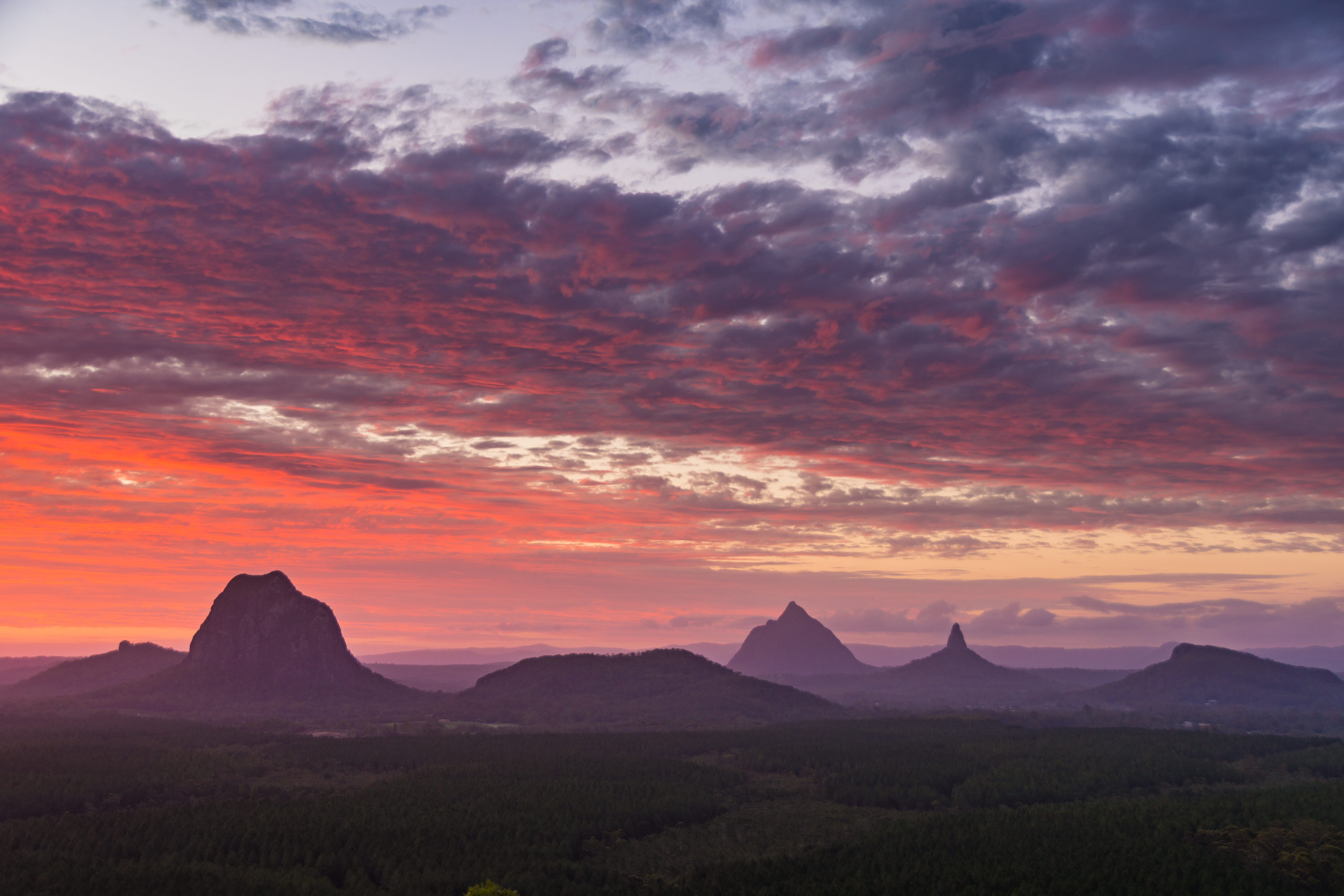
The Glass House Mountains are a cluster of thirteen hills that rise abruptly from the coastal plain on the Sunshine Coast, Queensland, Australia. The highest hill is Mount Beerwah at 556 metres above sea level, but the most identifiable of all the hills is Mount Tibrogargan which from certain angles bears a resemblance to a face staring east towards the ocean. The Glass House Mountains are located near Beerburrum State Forest and Steve Irwin Way. From Brisbane, the mountains can be reached by following the Bruce Highway north and taking the Glass House Mountains tourist drive turn-off onto Steve Irwin Way. The trip is about one hour from Brisbane. The Volcanic peaks of the Glass House Mountains rise dramatically from the surrounding Sunshine Coast landscape. They were formed by intrusive plugs, remnants of volcanic activity that occurred 26–27 million years ago.[1] Molten rock filled small vents or intruded as bodies beneath the surface and solidified into land rocks. Millions of years of erosion have removed the surrounding exteriors of volcanic cores and softer sandstone rock.[citation needed]
| Glass House Mountains | |
|---|---|
 Aerial photo of Glass House Mountains township with the Glass House Mountains in the distance | |
| Highest point | |
| Peak | Mount Beerwah |
| Elevation | 556 m (1,824 ft) |
| Coordinates | 26°54′S 152°55′E |
| Geography | |
 Glass House Mountains | |
| Country | Australia |
| State | Queensland |
| Region | South East Queensland |
| Geology | |
| Formed by | Volcanic plugs |
| Age of rock | Tertiary |
Whilst the traditional names for the hills themselves are very old, the term 'Glass House Mountains' was given more recently by explorer Lieutenant James Cook on 17 May 1770.[2] The peaks reminded him of the glass furnaces in his home county of Yorkshire.[3] Matthew Flinders explored the area and climbed Mount Beerburrum after sailing along Pumicestone Passage in 1799. The Glass House Mountains National Landscape was added to the Australian National Heritage List on 3 August 2006.[4] In the land between the peaks, pineapple and poultry farming, as well as commercial forestry and quarrying are the main land uses.[5]
In 2009 as part of the Q150 celebrations, the Glass House Mountains was announced as one of the Q150 Icons of Queensland for its role as a "Natural attraction".[6]
Geology
The range was formed as molten lava cooled to form hard rock in the cores of volcanoes 26–27 million years ago.[1] The source of the lava was from the East Australia hotspot. The cores of the hills contain columns of comendite from lava which cools quickly into a hard rock.[7] The surrounding softer rocks have been eroded in the subsequent time, forming the spectacular volcanic plugs that remain today.[3] The peaks' location relative to each other exhibits an alignment that is believed to have occurred due to fracturing.[5] Mt Ngungun consists of subvolcanic rock, also known as a hypabyssal rock, an intrusive rock emplaced at medium-to-shallow depths within the crust and has intermediate grain size, and often porphyritic texture between that of volcanic and plutonic rocks.[citation needed]
Peaks


Each of the peaks is protected within the Glass House Mountains National Park. Some of the peaks display vertical columns, particularly Mount Coonowrin, Mount Ngungun and Mount Beerwah at the Organ Pipes.[5] These columns are the result of lava contraction. Scattered throughout the hills are shallow caves which have been formed by wind erosion on rocks that were softened by groundwater.[5] The peaks are culturally significant to the traditional owners, the Gubbi Gubbi people. Under a native title claim, access to the peaks could be restricted as they are considered spiritual places.[3] To the south east of the Glass House Mountains township is an Aboriginal bora ring.[5] The names of each mountain in the range are:[citation needed]
- Mount Beerburrum, 278 m
- Mount Beerwah, 556 m
- Mount Coochin or The Coochin Hills, 235 m and 230 m
- Mount Coonowrin or Crookneck or Fakebig, 377 m
- Mount Elimbah or The Saddleback, 109 m
- Mount Ngungun, Mount Ngun Ngun said as Gun Gun 253 m
- Mount Tibberoowuccum, 220 m
- Mount Tibrogargan and Cooee, 364 m and 177 m
- Mount Tunbubudla or the Twins, 338 m and 294 m
- Wild Horse Mountain, 123 m
- Mount Miketeebumulgrai: 199 m
- Mount Ninderry 306 m
- Mount Coolum 208 m
Aboriginal cultural knowledge
The Glass House Mountains are located in the traditional lands of the Jinibara[8] and Gubbi Gubbi people. First Nations Australians have an elaborate legend about the mountains.[9]
Public access
The mountains are managed by Queensland National Parks and are promoted as a tourist asset. Historically bushwalking and climbing has been undertaken for more than a century. However the two largest mountains have been closed by National Parks in recent years. Firstly, Coonowrin was closed in 1999 as a result of a geological report and the development of an adjacent rock quarry. Secondly, the walking track used to access Mt Beerwah was closed in 2009 as the result of a rock collapse from the caves area across the main tourist track and was reopened January 2016. Tibrogargan and Ngungun are open to the public for bushwalking and climbing.[citation needed]
The Beerwah and Tibrogargan mountains are culturally significant and hold "sacred values" to the local Jinibara and Kabi Kabi people who request visitors do not climb the mountains.[10]
Flora and fauna
There are many different types of plants including trees, grass, bushes and the occasional shrub. Animals that live there include birds, reptiles, frogs, bats, rats, cats and mammals. The Elf Skink, a small lizard, also populates the area.[11]
See also
References
- Cohen, B. E.; Vasconcelos, P. M.; Knesel, K. M. (1 February 2007). "40Ar/39Ar constraints on the timing of Oligocene intraplate volcanism in southeast Queensland". Australian Journal of Earth Sciences. 54 (1): 105–125. doi:10.1080/08120090600981483. ISSN 0812-0099.
- "Glass House Mountains National Park and Beerburrum Forest Reserve 1 (entry 602494)". Queensland Heritage Register. Queensland Heritage Council. Retrieved 1 August 2014.
- Environmental Protection Agency (Queensland) (2000). Heritage Trails of the Great South East. State of Queensland. p. 127. ISBN 978-0-7345-1008-2.
- "National Heritage Places – Glass House Mountains National Landscape". Commonwealth of Australia. Archived from the original on 28 December 2014. Retrieved 29 November 2014.
- Shilton, Peter (2005). Natural Areas of Queensland. Mount Gravatt, Queensland: Goldpress. pp. 160–162. ISBN 978-0-9758275-0-5.
- Bligh, Anna (10 June 2009). "PREMIER UNVEILS QUEENSLAND'S 150 ICONS". Queensland Government. Archived from the original on 24 May 2017. Retrieved 24 May 2017.
- Willmott, Warwick (2004). Rocks and Landscapes of the National Parks of Southern Queensland. Brisbane, Queensland: Geological Society of Australia, Queensland Division. p. 162. ISBN 978-1-876125-46-2.
- "Jinibara People". QSNTS Website for Native Title claim area Jinibara. Archived from the original on 26 May 2015.
- "Glasshouse Aboriginal Legend". www.coolrunning.com.au. Archived from the original on 15 April 2018. Retrieved 3 October 2018.
- "Welcome to the Glass House Mountains National Park" (PDF). Queensland Government. Retrieved 24 December 2020.
{{cite web}}: CS1 maint: url-status (link) - "Elf skink (Eroticoscincus graciloides) at the Australian Reptile Online Database – AROD.com.au". www.arod.com.au. Archived from the original on 10 January 2018. Retrieved 19 March 2018.
External links
Australian places named on the First voyage of James Cook in 1770 | ||
|---|---|---|
| Victoria |
|  |
| New South Wales |
| |
| Queensland |
| |
*Places where Cook landed | ||
На других языках
[de] Glass House Mountains
Im Gebiet der Glass House Mountains, auch Glasshouse Mountains geschrieben, befinden sich zwölf vulkanische Berge, die sich abrupt aus der relativ flachen Ebene an der Sunshine Coast im Inland von Queensland in Australien erheben. Die Berge liegen etwa 70 Kilometer nördlich von Brisbane. Das Gebiet ist Teil der Great Dividing Range. Die Ebene zwischen und um die Berge wird vor allem zum Anbau von Ananas, zur Geflügelzucht und für Forst- und Holzwirtschaft genutzt.[1]- [en] Glass House Mountains
[es] Montañas Glass House
En la zona de las montañas Glass House, también llamada montañas Glasshouse, hay doce montañas volcánicas que se elevan abruptamente desde la llanura relativamente plana de Sunshine Coast, en el interior de Queensland, Australia. Las montañas se encuentran a unos 70 kilómetros al norte de Brisbane. La zona forma parte de la Gran Cordillera Divisoria. La llanura entre y alrededor de las montañas se utiliza principalmente para el cultivo de la piña, la avicultura y la silvicultura y la madera.[1][fr] Monts Glass House
Les monts Glass House sont un groupe de onze collines qui se dressent sur la plaine côtière de la Sunshine Coast, au Queensland, en Australie. La plus haute montagne est le mont Beerwah (556 mètres d'altitude) mais le plus identifiable de tous est le mont Tibrogargan qui apparaît comme un singe géant assis au bord du chemin et regardant la mer.Другой контент может иметь иную лицензию. Перед использованием материалов сайта WikiSort.org внимательно изучите правила лицензирования конкретных элементов наполнения сайта.
WikiSort.org - проект по пересортировке и дополнению контента Википедии