geo.wikisort.org - Coast
Point Lookout is a headland, small coastal town and locality on the eastern coast of North Stradbroke Island (Minjerribah), Redland City, Queensland, Australia.[2][3][4] At the 2021 census, the locality of Point Lookout had a population of 785 people.[1]
| Point Lookout Queensland | |||||||||||||||
|---|---|---|---|---|---|---|---|---|---|---|---|---|---|---|---|
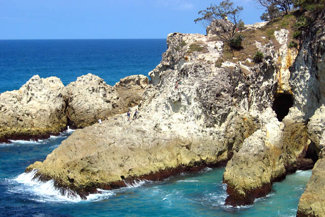 Eastern wall of the North Gorge, as seen from the Gorge Walk at Point Lookout | |||||||||||||||
 Point Lookout | |||||||||||||||
| Coordinates | 27.4297°S 153.54°E | ||||||||||||||
| Population | 785 (2021 census)[1] | ||||||||||||||
| • Density | 178.4/km2 (462/sq mi) | ||||||||||||||
| Postcode(s) | 4183 | ||||||||||||||
| Area | 4.4 km2 (1.7 sq mi) | ||||||||||||||
| Time zone | AEST (UTC+10:00) | ||||||||||||||
| Location | |||||||||||||||
| LGA(s) | Redland City | ||||||||||||||
| State electorate(s) | Oodgeroo | ||||||||||||||
| Federal division(s) | Bowman | ||||||||||||||
| |||||||||||||||
Geography

Point Lookout is Queensland's most easterly point. To the north lies Cape Moreton and to the south the next major headland is Point Danger on the New South Wales/Queensland border. The other towns on the island are Dunwich and Amity Point.[5]
In the west near the caravan park is Rocky Point and Adder Rock. Cylinder Beach extends eastwards towards Cylinder Headland. Frenchmans Beach fronts Frenchmans Bay. At the eastern extremity is North Gorge and Whale Rock. Offshore are several rocky outcrops above sea level. The headland is an ideal location for land-based seawatching in Australia.[6] Humpback whales can also be seen from here as they migrate along the east coast of Australia. The area is mostly residential houses and tourist apartments built close to the beach and atop nearby ridges to take advantage of sweeping Pacific Ocean views. There are a few shops and a caravan park at Point Lookout.[citation needed]
There is no railway on the island, the nearest station being in Cleveland 19 miles (31 km) to the west. Dunwich airport is 9 miles (14 km) southwest.[citation needed]
History
The point was sighted and named by James Cook on HMS Endeavour during his exploration of the east coast of Australia on 17 May 1770.[7]
In 1803 Matthew Flinders in the cutter Hope came ashore at Cylinder Beach (Hopewell) to find water as he was returning to Port Jackson (Sydney) after he was wrecked in HMS Porpoise on the Wreck Reefs off Gladstone. It is first recorded contact between the British and the Noonuccal people in this area. The Aboriginal people assisted Flinders in finding fresh water to fill his barrels.[8]
The Point Lookout Lighthouse was constructed in 1932, which is still in use today.[citation needed]
On 14 May 1943, the single greatest loss of life resulting from a submarine attack in Australian waters occurred 23 nautical miles (43 km; 26 mi) ENE off Point Lookout when the hospital ship AHS Centaur was sunk by a Japanese submarine. On 15 May 1994 Minister for Veterans Affairs, Con Sciacca, officially unveiled a memorial to the sinking of the Centaur on Cylinder Beach Headland.[9]
The Point Lookout Library opened in 2011.[10]
At the 2016 census, Point Lookout recorded a population of 713 people, 47.1% female and 52.9% male. The median age of the Point Lookout population was 53 years, 15 years above the national median of 38. 72.1% of people living in Point Lookout were born in Australia. The other top responses for country of birth were England 4.7%, New Zealand 2.1%, South Africa 1.4%, United States of America 1% and Philippines 0.7%. 85.2% of people spoke only English at home; the next most common languages were French 0.6%, Croatian 0.4% and Japanese 0.4%.[11]
At the 2021 census, Point Lookout recorded a population of 785 people, 47.6% female and 52.2% male. The median age of the Point Lookout population was 55 years. 71.5% of people living in Point Lookout were born in Australia. The other top responses for country of birth were England 5%, New Zealand 2%, United States of America 1.8%, South Africa 1%, and Thailand 0.9%. 83.2% of people spoke only English at home; the next most common languages were Italian 0.9%, Thai 0.8% and German 0.5%.[1]
Heritage listings
Point Lookout has one heritage site, Point Lookout Foreshore along East Coast Road (27.4306°S 153.5376°E).[12][13]
Education
There are no schools in Point Lookout. The nearest government primary school is Dunwich State School in Dunwich to the south-west. The nearest government secondary school is Cleveland District State High School in Cleveland on the mainland.[5]
Amenities
The Redland City Council operates a public library at the Point Lookout Community Hall (27.4260°S 153.5210°E) at 74-84 Dickson Way (also known as East Coast Road).[14][15]
Attractions

There is a monument commemorating the naming of Point Lookout by James Cook in 1770. It is opposite 19 Mooloomba Road, near the Gorge Walk (27.4330°S 153.5440°E).[7]
There is a monument commemorating the assistance the Aboriginal people gave to Matthew Flinders in 1803. It is at Hopewell Street on the Cylinder Beach Headland (27.4244°S 153.5350°E).[16]
There is a monument commemorating the Stradbroke Island Radar Site, which was part of Australia's air defence network during World War II. It is on the Gorge Walk off Headland Park Access Road (27.4353°S 153.5441°E).[17]
There is a monument commemorating the sinking of the AHS Centaur in Hopewell Street on Cylinder Beach Headland (27.4247°S 153.5353°E).[9]
See also
- List of seawatching locations by country
References
- Australian Bureau of Statistics (28 June 2022). "Point Lookout (SAL)". 2021 Census QuickStats. Retrieved 6 August 2022.
- "Point Lookout – headland in Redland City (entry 20078)". Queensland Place Names. Queensland Government. Retrieved 13 February 2022.
- "Point Lookout – population centre in Redland City (entry 27179)". Queensland Place Names. Queensland Government. Retrieved 13 February 2022.
- "Point Lookout – locality in Redland City (entry 43648)". Queensland Place Names. Queensland Government. Retrieved 13 February 2022.
- "Queensland Globe". State of Queensland. Retrieved 12 August 2022.
- Harris, Tim (2013). RSPB Migration Hotspots: The World's Best Bird Migration Sites. A&C Black. p. 212. ISBN 978-1408171172. Archived from the original on 7 March 2016. Retrieved 19 August 2015.
- "Bicentenary of the Naming of Point Lookout". Monument Australia. Archived from the original on 15 February 2022. Retrieved 15 February 2022.
- "History of Straddie". Archived from the original on 19 April 2021. Retrieved 15 February 2022.
- "A.H.S. Centaur Memorial". Monument Australia. Archived from the original on 7 May 2021. Retrieved 15 February 2022.
- "Queensland Public Libraries Statistical Bulletin 2016-2017" (PDF). Public Libraries Connect. State Library of Queensland. November 2017. p. 15. Archived (PDF) from the original on 30 January 2018. Retrieved 24 January 2018.
- Australian Bureau of Statistics (27 June 2017). "Point Lookout (SSC)". 2016 Census QuickStats. Retrieved 20 October 2018.
- "Schedule 4 - Heritage Places Register" (PDF). Redland City Council. March 2006. p. 3. Archived (PDF) from the original on 5 September 2020. Retrieved 5 September 2020.
- "Point Lookout Foreshore (entry 602261)". Queensland Heritage Register. Queensland Heritage Council. Retrieved 12 July 2013.
- "Point Lookout Library". Public Libraries Connect. State Library of Queensland. 16 October 2014. Archived from the original on 25 January 2018. Retrieved 24 January 2018.
- "Point Lookout Library". Redland City Council. Archived from the original on 23 October 2020. Retrieved 15 February 2022.
- "Act of Kindness". Monument Australia. Archived from the original on 15 February 2022. Retrieved 15 February 2022.
- "Stradbroke Island Radar Site". Monument Australia. Archived from the original on 15 February 2022. Retrieved 15 February 2022.
Further reading
- Diamond, Marion (1 July 2012), Stradbroke: a brief history, University of Queensland — full text available online
External links
- "Point Lookout". Redland City Council.
- "Town map of Point Lookout". Queensland Government. 1982.
Australian places named on the First voyage of James Cook in 1770 | ||
|---|---|---|
| Victoria |
|  |
| New South Wales |
| |
| Queensland |
| |
*Places where Cook landed | ||
Authority control | |
|---|---|
| General |
|
| National libraries | |
На других языках
- [en] Point Lookout, Queensland
[ru] Пойнт-Лукаут
Пойнт-Лукаут (англ. Point Lookout) — небольшой город на северо-востоке острова Северный Страдброк, юго-восточное побережье Квинсленда, Австралия. В 2006 году население города составило 669 человек, в 2016[1] — 713[2] человек.Другой контент может иметь иную лицензию. Перед использованием материалов сайта WikiSort.org внимательно изучите правила лицензирования конкретных элементов наполнения сайта.
WikiSort.org - проект по пересортировке и дополнению контента Википедии