geo.wikisort.org - Sea
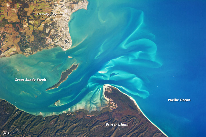
Hervey Bay (/ˈhɑːrvi/)[4] is a city on the coast of the Fraser Coast Region of Queensland, Australia.[5] The city is situated approximately 290 kilometres (180 mi) or 3½ hours' highway drive north of the state capital, Brisbane. It is located on the bay of the same name open to the Coral Sea between the Queensland mainland and nearby Fraser Island (also known as K'Gari and Gari).[6] The local economy relies on tourism which is based primarily around whale watching in Platypus Bay to the north, ferry access to Fraser Island, accessible recreational fishing and boating and the natural north facing, calm beaches with wide undeveloped foreshore zones. In October 2019, Hervey Bay was named the First Whale Heritage Site in the world by the World Cetacean Alliance, for its commitment to and practices of sustainable whale and dolphin watching.[7] A 2010 study by Deakin University showed that people on the Fraser Coast area including Hervey Bay, were the happiest in Australia.[8] At June 2018, there were an estimated 54,674 people in Hervey Bay,[1] having grown by an annual average of 1.31% year-on-year over the preceding five years.[1]
| Hervey Bay Queensland | |||||||||
|---|---|---|---|---|---|---|---|---|---|
 Torquay Beach, Hervey Bay | |||||||||
 Hervey Bay | |||||||||
| Coordinates | 25.29°S 152.84°E | ||||||||
| Population | |||||||||
| • Density | 586.6/km2 (1,519.4/sq mi) | ||||||||
| Postcode(s) | 4655 | ||||||||
| Area | 93.2 km2 (36.0 sq mi)[3] (2011 urban) | ||||||||
| Time zone | AEST (UTC+10:00) | ||||||||
| Location |
| ||||||||
| LGA(s) | Fraser Coast Region | ||||||||
| Region | Wide Bay-Burnett | ||||||||
| State electorate(s) | Hervey Bay | ||||||||
| Federal division(s) | Hinkler | ||||||||
| |||||||||
History

Butchulla (also known as Batjala, Badtjala, Badjela, and Badjala) is the language of the Fraser Coast region, including K’gari. Butchulla language region includes the landscape within the local government boundaries of the Fraser Coast Regional Council, particularly the towns of Maryborough and Hervey Bay extending south towards Noosa and north to Caboolture.[9]
The indigenous Batjala people including the Kabi Kabi are the traditional residents of Hervey Bay. (Batjala means Bat-No and Jala-tongu. This would mean they were shy people who did not communicate with people outside of their family group.) The first recorded European sighting of Hervey Bay was made by James Cook while carrying out his running survey of the east coast of Australia, on 22 May 1770. By noon Cook's ship was in a position a little over half-way across the opening of Hervey Bay heading for Bundaberg. When Cook first discovered Hervey Bay, he did not realize that Fraser Island was separated from mainland Australia; Cook did not travel far enough south due to the shallow depths of the waters in the Bay.[10] Cook named the bay "Hervey's Bay" after Augustus John Hervey (1724–1779), later Third Earl of Bristol, a naval officer who became a Lord of the Admiralty the year Endeavour returned.[11]
Until around the mid-1980s the area was serviced by a rail link from the main North Coast line that diverted from Aldershot and went through Takura, Walligan, Nikenbah, then on to Pialba and Urangan. The line was a major freight point for the Port of Maryborough and for the sugar cane industry until road transport assumed the role.
In 1984, Hervey Bay was officially known as the "City of Hervey Bay". It was known as a city because of its large growth in business, population, tourism, and industry. Although it was now being known as a city, it still remained a small seaside village to most of the local residents.
The Hervey Bay Library opened in 1997 and had a major refurbishment in 2014.[12]
In the 2016 census, Hervey Bay had a population of 52,073 people.[2] Aboriginal and Torres Strait Islander people made up 4.0% of the population. The median age of people was 48 years, ten years older than the national median age. 74.6% of people were born in Australia. The next most common countries of birth were England 5.9%, New Zealand 3.5%, Germany 0.8%, Scotland 0.6%, and Philippines 0.6%. 88.4% of people only spoke English at home. Other languages spoken at home included German 0.5%, French 0.2%, Mandarin 0.2%, Dutch 0.2%, and Italian 0.2%. The most common responses for religion were no religion 28.0%, Anglican 20.5%, and Catholic 18.9%.[2]
Heritage listings
Hervey Bay has a number of heritage-listed sites. K'gari is listed on the World Heritage List.[13] The Woody Island Lighthouses are listed on the Queensland Heritage Register.[14]
Transport


Hervey Bay is situated approximately 3½ hours' drive north of Brisbane, via the Bruce Highway and 30 minutes' drive north-east of Maryborough. The city is also served by the high-speed Tilt Train, which has connections from Maryborough West or nearby Howard. The city is served by the Hervey Bay Airport, with direct flights from Brisbane (QantasLink) and Sydney (Virgin Australia). The City of Hervey Bay (now the Fraser Coast Region) has released an airport master plan which includes future provision of a taxiway parallel to the main runway, additional car parking and a larger terminal. The city is also served by passenger ferry to Fraser Island, as well as both scheduled and unscheduled vehicular ferries.[citation needed]
Railway
Despite Hervey Bay's growing popularity, no plans have been made for a new railway line to the city. The previous passenger and freight line branched off the North Coast main line at Colton, just north of Maryborough. Trains stopped at many stations along the line, but the main stations were Pialba and Urangan. The railway then extended along the Urangan Pier. The line carried out pineapples and local goods from the city. The line was closed in 1993. The tracks from Nikenbah to Urangan were removed and the Pialba – Urangan line was converted into a rail trail.[15] Traces of the railway line are still visible in Urangan. There are two semi-removed crossings (Everything but the tracks was removed) near the end of Pier Street and the track's ballast is still slightly visible from where the mobility corridor ends.[citation needed]
Governance
Hervey Bay is the largest population centre within the Fraser Coast Region. The current mayor of the Fraser Coast Regional Council is George Seymour first elected in a by-election held in May 2018[16] and re-elected in the 2020 quadrennial local government elections in March 2020. A total of ten Councillors are elected every four years.[citation needed]
The Electoral district of Hervey Bay has Queensland's second highest share of residents aged over 60.[17]
Hervey Bay is represented in the Parliament of Queensland by Labor member Adrian Tantari, and in the Commonwealth Parliament by the Nationals member for Hinkler, Keith Pitt.[18]
Climate
Hervey Bay has a humid subtropical climate with an average high temperature of around 30 °C (86 °F) in summer and 22 °C (72 °F) in winter. The coast is predominantly affected by the south east trade winds throughout the summer with occasional strong northerly winds and storm swells. These winds keep the temperatures down in summer and up in winter, preventing temperature extremes. As a result, Hervey Bay rarely experiences temperatures over 32.3 °C (90.1 °F) in summer or under 4.6 °C (40.3 °F) in winter.
Tropical cyclones are a threat at times with Cyclone Hamish threatening in 2009 as a Category 5. The land mass of Fraser Island significantly affects the pattern of weather in Hervey Bay and protects the immediate marine environment from open ocean storm effects. Cyclone Oswald in 2013 caused significant damage in the area, mainly as a result of tornadoes spawned by the system. The average rainfall for the year is around 1,029.7 millimetres (40.54 in). December to March is the main rainy period, with a secondary peak in May and June. The months of April and from July to November are generally dry and sunny.
| Climate data for Hervey Bay Airport, Queensland, Australia (1999-present normals and extremes); 13 m AMSL | |||||||||||||
|---|---|---|---|---|---|---|---|---|---|---|---|---|---|
| Month | Jan | Feb | Mar | Apr | May | Jun | Jul | Aug | Sep | Oct | Nov | Dec | Year |
| Record high °C (°F) | 35.2 (95.4) |
34.7 (94.5) |
35.4 (95.7) |
32.0 (89.6) |
29.6 (85.3) |
27.6 (81.7) |
26.1 (79.0) |
29.5 (85.1) |
31.2 (88.2) |
33.0 (91.4) |
34.5 (94.1) |
36.8 (98.2) |
36.8 (98.2) |
| Mean maximum °C (°F) | 32.2 (90.0) |
32.3 (90.1) |
31.1 (88.0) |
29.1 (84.4) |
26.7 (80.1) |
24.5 (76.1) |
24.0 (75.2) |
24.8 (76.6) |
26.8 (80.2) |
28.4 (83.1) |
30.0 (86.0) |
31.2 (88.2) |
32.3 (90.1) |
| Average high °C (°F) | 30.3 (86.5) |
30.2 (86.4) |
29.1 (84.4) |
27.1 (80.8) |
24.3 (75.7) |
22.1 (71.8) |
21.9 (71.4) |
22.9 (73.2) |
25.0 (77.0) |
26.6 (79.9) |
28.2 (82.8) |
29.5 (85.1) |
26.4 (79.6) |
| Daily mean °C (°F) | 26.2 (79.2) |
26.1 (79.0) |
24.9 (76.8) |
22.5 (72.5) |
19.2 (66.6) |
17.0 (62.6) |
16.0 (60.8) |
16.7 (62.1) |
19.5 (67.1) |
21.8 (71.2) |
23.7 (74.7) |
25.3 (77.5) |
21.6 (70.8) |
| Average low °C (°F) | 22.0 (71.6) |
22.0 (71.6) |
20.7 (69.3) |
17.8 (64.0) |
14.1 (57.4) |
11.9 (53.4) |
10.0 (50.0) |
10.4 (50.7) |
13.9 (57.0) |
16.9 (62.4) |
19.1 (66.4) |
21.0 (69.8) |
16.7 (62.0) |
| Mean minimum °C (°F) | 19.0 (66.2) |
19.5 (67.1) |
18.0 (64.4) |
15.0 (59.0) |
8.7 (47.7) |
6.8 (44.2) |
4.6 (40.3) |
5.4 (41.7) |
9.0 (48.2) |
12.1 (53.8) |
15.1 (59.2) |
17.6 (63.7) |
4.6 (40.3) |
| Record low °C (°F) | 16.0 (60.8) |
16.6 (61.9) |
15.6 (60.1) |
7.0 (44.6) |
4.0 (39.2) |
1.8 (35.2) |
−1.2 (29.8) |
−0.1 (31.8) |
2.9 (37.2) |
6.8 (44.2) |
9.1 (48.4) |
13.4 (56.1) |
−1.2 (29.8) |
| Average precipitation mm (inches) | 124.6 (4.91) |
134.6 (5.30) |
134.8 (5.31) |
65.9 (2.59) |
89.8 (3.54) |
75.9 (2.99) |
41.2 (1.62) |
50.8 (2.00) |
35.1 (1.38) |
81.9 (3.22) |
72.8 (2.87) |
122.3 (4.81) |
1,029.7 (40.54) |
| Average precipitation days (≥ 1.0 mm) | 8.3 | 9.2 | 10.8 | 9.2 | 9.8 | 8.4 | 5.2 | 3.7 | 3.8 | 5.2 | 6.4 | 7.9 | 87.9 |
| Average relative humidity (%) | 64.0 | 67.0 | 66.5 | 67.5 | 67.5 | 70.5 | 65.0 | 61.5 | 62.0 | 61.5 | 60.5 | 62.5 | 64.7 |
| Average dew point °C (°F) | 20.0 (68.0) |
20.5 (68.9) |
19.4 (66.9) |
17.5 (63.5) |
14.3 (57.7) |
12.7 (54.9) |
10.7 (51.3) |
11.1 (52.0) |
14.0 (57.2) |
15.8 (60.4) |
16.7 (62.1) |
18.8 (65.8) |
16.0 (60.7) |
| Source: Australian Bureau of Meteorology (1999-present extremes)[19] | |||||||||||||
Localities

Hervey Bay began as a dispersed community spread over numerous small, seaside villages. As the area grew, these communities amalgamated and became suburbs . The current urban area includes the following settlements:[citation needed]
- Booral
- Bunya Creek
- Craignish
- Dundowran
- Dundowran Beach
- Eli Waters
- Kawungan
- Nikenbah
- Pialba
- Point Vernon
- Scarness
- Sunshine Acres
- Susan River
- Takura
- Toogoom
- Torquay
- Urangan
- Urraween
- Walligan
- Wondunna
Education
Hervey Bay has 14 schools.[20]
| Pre | Primary | Secondary | |
|---|---|---|---|
| Public |
|
||
| Private |
|
|
Hervey Bay also has two Higher Education institutes, a campus of the University of the Sunshine Coast and the Wide Bay Institute of TAFE.[36][37] and a State Government Special School.
Amenities
The Fraser Coast Regional Council operate the Hervey Bay Library at 161 Old Maryborough Road, Pialba.[38]
LifeChurch Hervey Bay meets at the Community Centre at 22 Charles Street in Pialba.[39] It is part of the Wesleyan Methodist Church of Australia.[40]
Media
Along with a number of other regional Australian newspapers owned by NewsCorp, the Hervey Bay Independent newspaper ceased publication in June 2020.[41]
In April 2022, the Australian Broadcasting Corporation opened a bureau at Hervey Bay to improve its coverage of the Fraser Coast.[42] Staffed by two locally-based journalists, the new bureau on Boat Harbour Drive was opened as part of the ABC's regional expansion.[43]
Commerce
Hervey Bay and the Fraser Coast region's largest shopping centre is Stockland Hervey Bay.[44] It is a regional shopping center located in the suburb of Urraween. Stockland Acquired the centre in April 2011, at the time it had a floor area of 15,600 square meters, and 48 stores. In 2013 Stockland begun construction of a $115 million redevelopment that would double the floor area to over 35,000 square metres.[44] The development would include an additional 70 specialty stores and a 500-seat food court, taking the total number of stores to 110.[45]
Sports

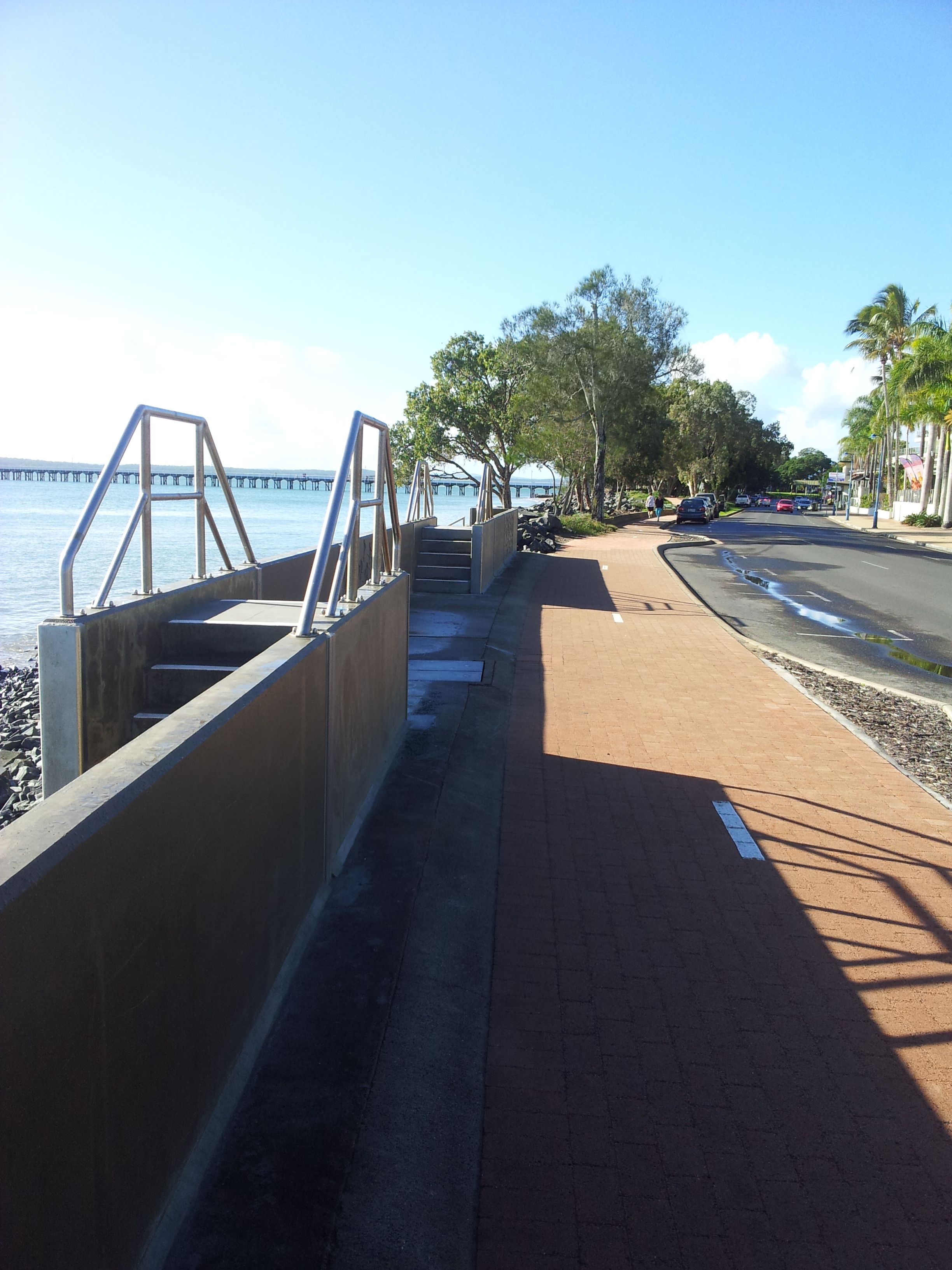
Hervey Bay has an active sporting community with the geography and climate encouraging a diverse range of activities. The natural foreshore area of Hervey Bay has a 14-kilometre (8.7 mi) long bike and pedestrian path that visibly integrates recreational fitness into the environment and community.[citation needed]
Competition sports are generally regional and played against nearby cities, Bundaberg, Maryborough and Gympie.[citation needed]
The calm waters and gently sloped beaches make recreational and competitive water sports popular and accessible. These include sailing, kite boarding, water skiing, wake boarding, kayaking, out-rigging, snorkelling, scuba diving, and ocean swimming.[citation needed]
The Hervey Bay Triathlon started in 1988 and has been raced annually since.[citation needed]
The local rugby league team, Hervey Bay Seagulls, are the cornerstone of rugby league in the Hervey Bay area.[citation needed]

Whale watching
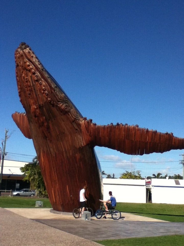
Hervey Bay is the whale watching capital of Australia, with humpback whales migrating along the coast between April and October every year. Researchers at The Oceania Project conducted a 25-year study which found the bay was an important social hub for humpback whales.[46] Whale number have increased from about 2,000 in 1992, to around 33,000 in 2018.[46] Hervey Bay is a stopover for mature female humpback whales. Mature females visit Hervey Bay during August in company with the cohort of immature males and females. During September and October Hervey Bay is dominated by Mature females with new calves. The humpback whales are known to be very relaxed in the company of the whale watching vessels. Southern right whales have also been recorded with increasing sighting rates.[47]
Sister cities
According to the Australian Sister Cities Association, Hervey Bay has two sister cities:
See also
- Urangan Pier
- Great Sandy Biosphere Reserve
References
- "3218.0 – Regional Population Growth, Australia, 2017-18: Population Estimates by Significant Urban Area, 2008 to 2018". Australian Bureau of Statistics. Australian Bureau of Statistics. 27 March 2019. Archived from the original on 27 March 2019. Retrieved 25 October 2019. Estimated resident population, 30 June 2018.
- Australian Bureau of Statistics (27 June 2017). "Hervey Bay (UCL)accessdate=20 October 2018". 2016 Census QuickStats.
- "2011 Census Community Profiles: Hervey Bay". ABS Census. Australian Bureau of Statistics. Archived from the original on 5 March 2018. Retrieved 15 September 2016.
- "Hervey Bay". Macquarie Dictionary. Archived from the original on 17 December 2021. Retrieved 26 May 2021.
- "Hervey Bay – population centre in Fraser Coast Region (entry 46749)". Queensland Place Names. Queensland Government. Retrieved 28 February 2018.
- "Hervey Bay – bay in Fraser Coast Region (entry 15808)". Queensland Place Names. Queensland Government. Retrieved 28 February 2018.
- Hegarty, ABC News: Nicole (11 October 2019). "World-first Whale Heritage Site status awarded to Hervey Bay". ABC News. Archived from the original on 29 September 2021. Retrieved 29 September 2021.
- Walker, By Carlie (10 January 2013). "Double dose of happiness for Hervey Bay man". The Courier Mail. Archived from the original on 14 January 2013. Retrieved 29 September 2021.
- "Indigenous languages map of Queensland". State Library of Queensland. 2020. Archived from the original on 2 October 2020. Retrieved 21 January 2020.
- History of Hervey Bay Archived 29 October 2013 at the Wayback Machine. Retrieved 31 July 2014.
- Ray Parkin, H. M. Bark Endeavour, Miegunyah Press, 2nd edition 2003, ISBN 0-522-85093-6
- "Public Libraries Statistical Bulletin 2016-17" (PDF). Public Libraries Connect. State Library of Queensland. November 2017. p. 13. Archived (PDF) from the original on 30 January 2018. Retrieved 30 January 2018.
- "Fraser Island". UNESCO. Archived from the original on 23 October 2015. Retrieved 4 November 2015.
- "Woody Island Lighthouses & Ancillary Building Site (entry 602169)". Queensland Heritage Register. Queensland Heritage Council. Retrieved 7 July 2013.
- Links Mobility Corridor – Trail Description Archived 24 October 2009 at the Wayback Machine. Railtrails Australia.
- "2018 Fraser Coast RC Mayoral By-Election - Fraser Coast Regional Council - Undivided Council Summary". Electoral Commission of Queensland. 14 May 2018. Archived from the original on 14 May 2018. Retrieved 14 May 2018.
- Green, Antony. "Hervey Bay". Australian Broadcasting Corporation. Archived from the original on 1 May 2012. Retrieved 21 May 2012.
- Clementine Norton (8 January 2010). "Water to be sent to Hervey Bay". News Mail. The Bundaberg Newspaper Company. Archived from the original on 6 July 2011. Retrieved 14 March 2011.
- "Hervey Bay Airport, QLD Climate (1999-present extremes)". Australian Bureau of Meteorology. Archived from the original on 19 May 2022. Retrieved 18 May 2022.
- Hervey Bay schools - a directory of the schools in Hervey Bay Archived 12 October 2013 at the Wayback Machine. Retrieved 31 July 2014.
- "Kawungan SS". Archived from the original on 2 February 2017. Retrieved 28 January 2017.
- "Urangan Point SS". Archived from the original on 2 February 2017. Retrieved 28 January 2017.
- "Yarrilee SS". Archived from the original on 2 February 2017. Retrieved 28 January 2017.
- "Pialba SS". Archived from the original on 2 February 2017. Retrieved 28 January 2017.
- "Sandy Strait SS". Archived from the original on 2 February 2017. Retrieved 28 January 2017.
- "Torquay SS". Archived from the original on 2 February 2017. Retrieved 28 January 2017.
- "Hervey Bay SHS". Archived from the original on 2 February 2017. Retrieved 28 January 2017.
- "Urangan SHS". Archived from the original on 2 February 2017. Retrieved 28 January 2017.
- "Carinity Education - Glendyne". Archived from the original on 2 February 2017. Retrieved 28 January 2017.
- "Star of the Sea". Archived from the original on 2 February 2017. Retrieved 28 January 2017.
- "Fraser Coast Anglican College". Archived from the original on 2 February 2017. Retrieved 28 January 2017.
- "Xavier Catholic College". Archived from the original on 4 February 2017. Retrieved 28 January 2017.
- "St James Lutheran College". Archived from the original on 2 February 2017. Retrieved 28 January 2017.
- "Bayside Christian College". Facebook. Archived from the original on 5 March 2018. Retrieved 28 January 2017.
- "Hervey Bay Educational & Performing Arts Primary & High School". 3 July 2022. Archived from the original on 4 August 2020. Retrieved 23 July 2022.
- "Fraser Coast Campus". Archived from the original on 14 June 2011. Retrieved 5 March 2018.
- Queensland, TAFE. "TAFE Queensland". www.widebay.tafe.qld.gov.au. Archived from the original on 17 June 2017. Retrieved 5 March 2018.
- "Location and hours". Fraser Coast Regional Council. Archived from the original on 31 January 2018. Retrieved 31 January 2018.
- "LifeChurch Hervey Bay". Wesleyan Methodist Church Australia. Archived from the original on 24 August 2021. Retrieved 24 August 2021.
- "South Queensland". Wesleyan Methodist Church Australia. Archived from the original on 21 August 2021. Retrieved 25 August 2021.
- "Future is digital: News announces major changes". Gatton Star. 28 May 2020. Archived from the original on 22 December 2020. Retrieved 22 December 2020.
- "ABC opens new media bureau in Hervey Bay". Mediaweek. 7 April 2022. Archived from the original on 7 April 2022. Retrieved 1 June 2022.
- "ABC Hervey Bay bureau a fresh news voice in Queensland as part of regional media expansion". ABC News. 7 April 2022. Archived from the original on 1 June 2022. Retrieved 1 June 2022.
- "Stockland Hervey Bay Retail Centre". PDT Architects. 13 May 2014. Archived from the original on 13 July 2019. Retrieved 13 July 2019.
- "Stockland to double size of Hervey Bay shopping complex". www.businessspectator.com.au. Archived from the original on 28 March 2013. Retrieved 13 October 2015.
- "Bay's a social hub for whales". Fraser Coast Chronicle. The Maryborough Hervey Bay Newspaper Company. 7 August 2010. Retrieved 31 January 2012.
- "Southern right whales in Hervey Bay | Pacific Whale Foundation". Archived from the original on 26 November 2020. Retrieved 17 February 2021.
- "Leshan, China". Fraser Coast Regional Council. Archived from the original on 3 March 2013. Retrieved 21 May 2012.
External links
 Hervey Bay travel guide from Wikivoyage
- "Hervey Bay". Queensland Places. Centre for the Government of Queensland, University of Queensland.
- Town maps: Sheet 1, Sheet 2, Sheet 3, Sheet 4
- Hervey Bay
- Old Hervey Bay City Council Website
Australian places named on the First voyage of James Cook in 1770 | ||
|---|---|---|
| Victoria |
|  |
| New South Wales |
| |
| Queensland |
| |
*Places where Cook landed | ||
Authority control | |
|---|---|
| General | |
| National libraries | |
На других языках
[de] Hervey Bay
Hervey Bay ist eine Stadt im australischen Bundesstaat Queensland und liegt etwa 300 km nördlich von Brisbane an der Küste.- [en] Hervey Bay
[ru] Харви-Бей
Харви-Бей (англ. Hervey Bay) — город в штате Квинсленд. Расположен в 290 км к северу от столицы штата, Брисбена. Побережье Харви-Бея — естественный залив между континентальным Квинслендом и близлежащим островом Фрейзер. Местная экономика основана на туризме, в основном на фотоохоте и наблюдении за китами.Другой контент может иметь иную лицензию. Перед использованием материалов сайта WikiSort.org внимательно изучите правила лицензирования конкретных элементов наполнения сайта.
WikiSort.org - проект по пересортировке и дополнению контента Википедии