geo.wikisort.org - Island
Fraser Island (Butchulla: K'gari) is a World Heritage-listed island along the south-eastern coast in the Wide Bay–Burnett region, Queensland, Australia.[2][3] The island is approximately 250 kilometres (160 mi) north of the state capital, Brisbane, and is within the Fraser Coast Region local government area.[2] The world heritage listing includes the island, its surrounding waters and parts of the nearby mainland.[4]
| Fraser Island Queensland | |||||||||||||||
|---|---|---|---|---|---|---|---|---|---|---|---|---|---|---|---|
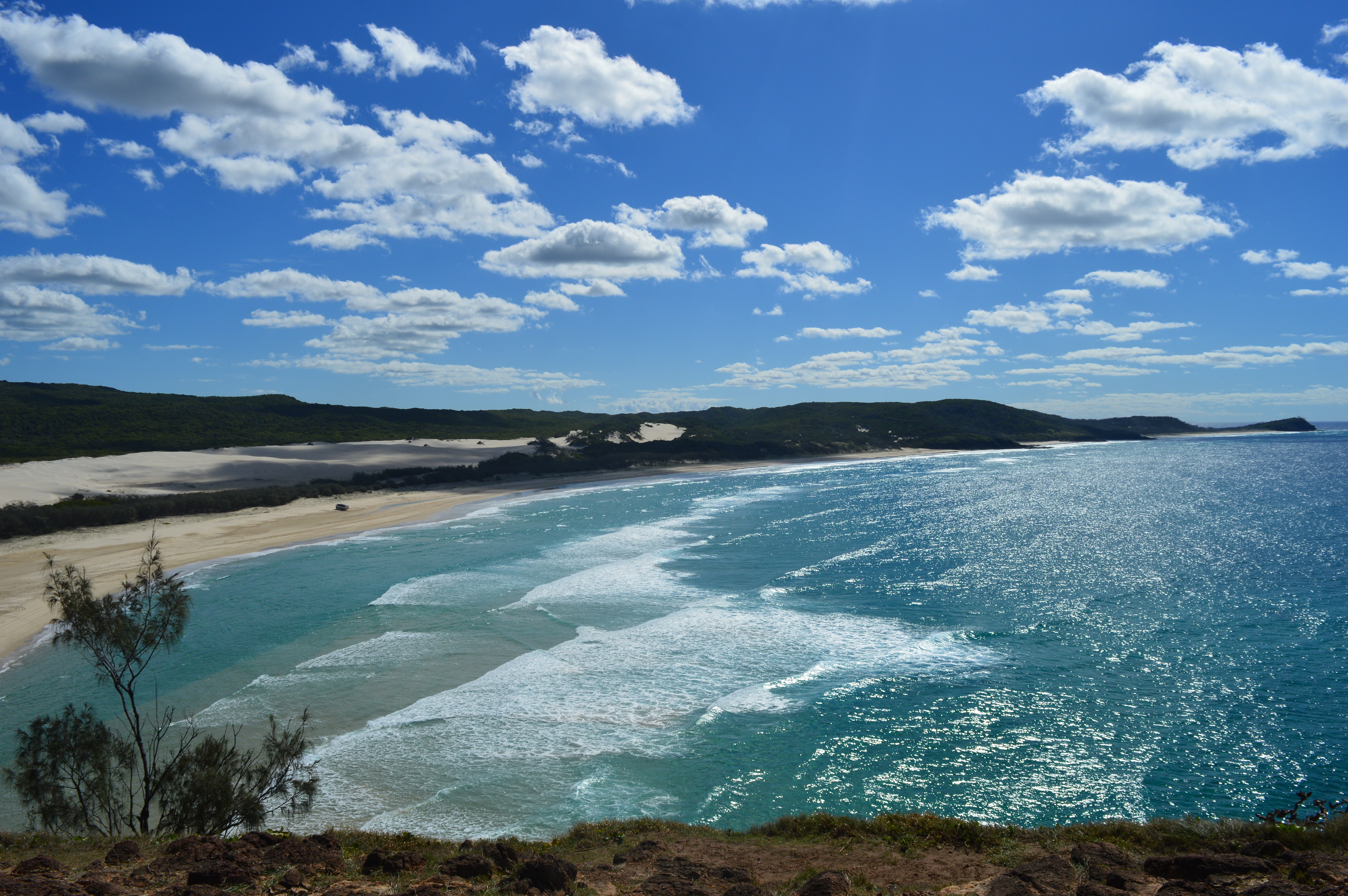 View of the beach from Indian Head, May 2016 | |||||||||||||||
 Fraser Island | |||||||||||||||
| Coordinates | 25°13′S 153°08′E | ||||||||||||||
| Population | 182 (2016 census)[1] | ||||||||||||||
| • Density | 0.10997/km2 (0.2848/sq mi) | ||||||||||||||
| Postcode(s) | 4581 | ||||||||||||||
| Area | 1,655.0 km2 (639.0 sq mi) | ||||||||||||||
| Time zone | AEST (UTC+10:00) | ||||||||||||||
| LGA(s) | Fraser Coast Region | ||||||||||||||
| State electorate(s) |
| ||||||||||||||
| Federal division(s) | Wide Bay | ||||||||||||||
| |||||||||||||||
| UNESCO World Heritage Site | |
|---|---|
| Criteria | Natural: vii, viii, ix |
| Reference | 630 |
| Inscription | 1992 (16th Session) |
Fraser Island, and some satellite islands off the southern west coast and thus in the Great Sandy Strait, previously formed the County of Fraser, which was subdivided into six parishes. Among the islands were Slain Island, Tooth Island, Roundbush Island, Moonboom Island, Gardner Island, Dream Island, Stewart Island, and the Reef Islands, all part of the southernmost parish of Talboor.[citation needed]
The island is about 123 kilometres (76 mi) long and 22 kilometres (14 mi) wide.[5] It was inscribed as a World Heritage Site in 1992.[3] The island is considered to be the largest sand island in the world at 1,840 square kilometres (710 sq mi).[5] It is also Queensland's largest island, Australia's sixth largest island and the largest island on the east coast of Australia.
Fraser Island has rainforests, eucalyptus woodland, mangrove forests, wallum and peat swamps, sand dunes and coastal heaths. It is made up of sand that has been accumulating for approximately 750,000 years on volcanic bedrock that provides a natural catchment for the sediment carried on a strong offshore current northwards along the coast. Unlike on many sand dunes, plant life is abundant due to the naturally occurring mycorrhizal fungi present in the sand, which release nutrients in a form that can be absorbed by the plants.[6] The island is home to a small number of mammal species,[7] as well as a diverse range of birds, reptiles and amphibians, including the occasional saltwater crocodile. The island is protected as part of the Great Sandy National Park, and is a popular tourism destination.[8]
The island has been inhabited for as long as 5,000 years.[9][6] Explorer James Cook sailed by the island in May 1770. Matthew Flinders landed near the most northern point of the island in 1802. The traditional Butchulla name is K'gari or Gari. For a short period the island was known as Great Sandy Island before becoming Fraser Island, named after James Fraser who died there after become shipwrecked on a nearby reef.
In 1992, Fraser Island was listed as a UNESCO World Heritage Site.[10] In 2021, the listing was updated to add the traditional Butchulla Aboriginal name of K'gari[11] as well as the island's official name of Fraser Island. In 2009, as part of the Q150 celebrations, Fraser Island was announced as one of the Q150 Icons of Queensland for its role as a "Natural attraction".[12]
Toponymy
The earliest known name of the island is "K'gari" in the Butchulla (Badjala) language (pronounced "gurri"). It comes from a creation story- according to the Butchulla Dreaming story, the creator being Beiral sent his messenger Yendingie to create land and sea for the people. His helper, a "beautiful white spirit called Princess K’gari", worked hard to create the shores and the land, but afterwards persuaded Yedingie to let stay on their beautiful creation. In order to stay, she had to be changed into an island, so Yedingie created lakes, vegetation, animals and people to keep her company. She remains today, happy "in, and as a 'paradise'".[13]
After European colonisation, it was called Great Sandy Island then Fraser Island from 1842, after James Fraser who was shipwrecked nearby. [14][15]
The island has also been referred to as Thoorgine, or Thoorgine Island.[16][17]
In 2011, the Indigenous names of K'gari and Gari were entered as an alternative names for the island in the Queensland Place Names register.[2]
In 2017, the Queensland National Parks and Wildlife Service began referring to the Fraser Island section of Great Sandy National Park as the K'gari (Fraser Island) section,[18] in recognition of the Butchulla name.[19]
In September 2021, the World Heritage Area within Great Sandy National Park, along with the surrounding waters and parts of the nearby mainland, had been renamed K’gari, the original Butchulla people’s name for the island. The move was celebrated at a ceremony with Elders and representatives of the Butchulla people on Fraser Island. The name change had been formally adopted at the 44th session of the World Heritage Committee, and is a major milestone in a long running campaign by the region's traditional owners.[4][15]
History
Pre-settlement
The island was part of the traditional lands of the Badjala people before European settlement.[20]
Eliza Fraser
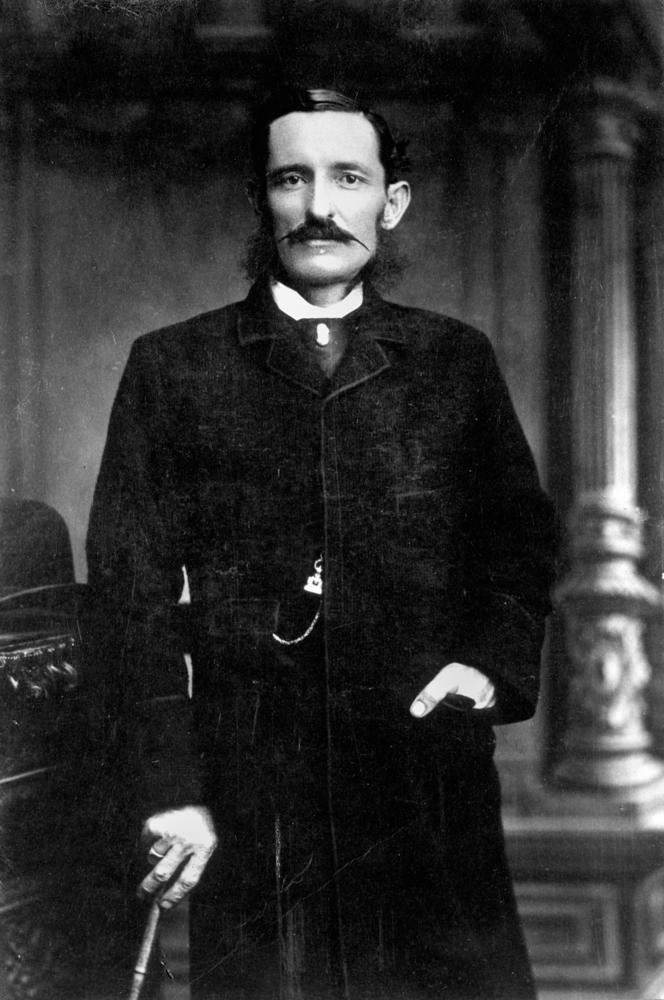
Captain James Fraser and his wife, Eliza Fraser, were shipwrecked on the island in 1836. Their ship, the brig Stirling Castle, set sail from Sydney to Singapore with 18 crew and passengers. The ship was holed on coral while travelling through the Great Barrier Reef north of the island.[21] Transferring to two lifeboats, the crew set a course south, attempting to reach the settlement at Moreton Bay (now Brisbane). During this trip in the leaking lifeboats, Captain Fraser's pregnant wife gave birth in water up to her waist; the infant drowned after birth. The Captain's lifeboat was becoming more and more unseaworthy and was soon left behind by the other lifeboat which continued on. The sinking boat and its crew was beached on what was then known as the Great Sandy Island. Whether the survivors died due to disease, hunger, exhaustion or battles with the native population will never be known for sure; most likely a little of all of the above. Captain Fraser died leaving Eliza living among the local peoples. She was rescued 6 weeks later by a convict, John Graham,[22] who had lived in the bush as an escapee and who spoke the Aboriginal language. He was sent from the settlement at Moreton Bay by the authorities there who had heard about Eliza's plight, and negotiated her return.[23] Within 6 months, Eliza had married another sea captain. She moved to England and became a sideshow attraction in Hyde Park telling ever more lurid tales about her experiences with the enslavement of the crew, cannibalism, torture, and murder. As she is known to have told several versions of the story, it is unknown which (if any) version was most accurate.[24][25] She was killed in a carriage accident in Melbourne in 1858 during a visit.[21] Fraser's stories were later disputed.[26]
Butchulla
Butchulla (also known as Batjala, Badtjala, Badjela and Badjala) is the language of the Fraser Coast region, including Fraser Island. Butchulla language region includes the landscape within the local government boundaries of the Fraser Coast Regional Council, particularly the towns of Maryborough and Hervey Bay extending south towards Noosa.[27]
Archaeological research and evidence shows that Aboriginal Australians occupied Fraser Island at least 5,000 years ago. There was a permanent population of 400–600 that grew to 2,000–3,000 in the winter months due to abundant seafood resources. The arrival of Europeans in the area was an overwhelming disaster for the Butchulla people. European colonisation in the 1840s destroyed the foundations of Aboriginal life.[7] By 1890, it was reported the permanent Butchulla island population had been reduced to only 300 people.[28] Most of these people were taken off the island in 1904 and relocated to missions in Yarrabah and Durundur, Queensland.[29] It is estimated that up to 500 Indigenous archaeological sites are located on the island.[30]
In October 2014, Native title rights were granted to the Butchulla people by the Federal Court. This essentially enables Butchulla people to hunt, fish and take water for domestic purposes; and opens the island up to economic opportunities for current and future generations of Butchulla people through ecotourism and related business development.[31]
British exploration
Initial European contact was limited to explorers and shipwrecks. The first recorded Briton to sight Fraser Island was James Cook who passed along the coast of the island between 18 and 20 May 1770. He named Indian Head after viewing a number of Aboriginal people gathered on the headland. After Cook's passage an Aboriginal song was composed to commemorate the event. This was later recognised as the first preserved oral testimony of Indigenous observation of Europeans.[32] Matthew Flinders sailed past the island in 1799, and again in 1802, this time landing at Sandy Cape,[33] while charting Hervey Bay. His 1814 chart is a combination of both voyages, but did not confirm Fraser Island as being separate from the mainland. However, Flinders did suggest the presence of shallow swampy areas at the lower part of the bay. Flinders was told of an opening at Hook Point, between Fraser Island and the mainland, by two American whalers who were hunting whales in Hervey Bay.[34] In 1842, Andrew Petrie recorded good pastoral lands and forests, attracting graziers to the region.[35] Lieutenant Robert Dayman was the first European to sail between Fraser Island and the mainland in 1847.[36]
Frontier Conflict 1851-1860
Non-Indigenous settlement of the traditional Butchulla mainland area began in 1847, sparking frontier conflict.
Violence by Aboriginals against settlers was reported.[37] In October 1850, "blacks had driven away 2000 sheep from a station about forty miles from here, and had killed a shepherd."[38] In 1851, a small government force including Commandant Frederick Walker and a contingent of the Native Police force were called in "for the purpose of endeavouring to apprehend some aboriginal natives who stand charged with various offences, and who have hitherto found shelter in the scrub" of Fraser Island.[39] Walker had received advice from the Attorney-General of New South Wales, John Hubert Plunkett, "It must, unhappily, be expected that the proposed attempt at arrest may lead to a warlike conflict and perhaps to loss of life, but the aim of the law must not be paralysed by the expectation of such results".[40]
The force included Walker, Lieutenant Richard Marshall, Sergeant Doolan, three divisions of troopers, and armed locals including James Leith Hay, aboard a schooner. A boat stolen by Aboriginals was captured along the way, while another "escaped, but it is probable it was sunk, as a great many shots were fired into it."[41] The force landed on the west coast of the island where the divisions split up. During the night, conflict began and a number of Aboriginals were shot and others captured. The weather was bad and Commandant Walker allowed his division to track down other groups without him. This group tracked a group of Aboriginals across the island to the east coast where they pursued them into the open ocean to an unknown fate. After months of conflict, the force returned to Maryborough in early January 1852 and Captain Currie received a reward of £10 for his contribution.[42] Recent research has shown that the native police operations on Fraser Island during 24 December 1851 and 3 January 1852 were lawful and that only two Aboriginals were killed while attacking Walker’s police party on the night of 27 December 1851.[43]
Despite this, British commissioners stationed in Maryborough reported non-Indigenous occupants felt threatened by Butchulla people.[44] In 1857, a Native Police barracks under the command of Lieutenant John O'Connell Bligh was established at Coopers Plains, now Owanyilla, not far from Maryborough. Bligh conducted further forays into Fraser Island,[45] Cooloola and in the town of Maryborough itself.[46]
The 'White Girls' of Fraser Island
In 1859 rumours of two shipwrecked 'white' girls living with Butchulla people on Fraser Island gained some credence when Captain Arnold of the Coquette arrived in Sydney with information seeming to confirm the story.[47] Public interest was stirred and Arnold was requested by the New South Wales Government to return to the island with a rescue party, obtaining the right to a £200 bonus if the girls were brought back. The expedition was carried out with the aid of an Aboriginal man named Tommy, who identified the Aboriginal camp near Indian Head where two girls aged about 12 and 18 were located and captured.[48] On taking them to Sydney, it became evident through their appearance and through their complete lack of knowledge of the English language that the girls were likely Aboriginal 'half-castes'. Edward Preddy of the rescue party wrote that "they could not converse with any of us, nor did they seem capable of talking with the blacks."[45] Arthur Macalister stated that he "thought it very probable that these girls were half castes, and that the whole thing was a trick".[49] Further discredit was placed on the process when it was found that the Aboriginal people who were paid by the search party to find the girls were rewarded in worthless commemorative coins instead of real money.[50] The girls, 'Kitty' Mundi and 'Maria' Quoheen/Coyeen, were not returned to their home but were initially kept at the Immigration Depot, where they yearned for their family.[51] Kitty, the eldest of the two, suffered severe mental distress and died shortly afterwards. Maria survived for about 20 years, dying from pulmonary tuberculosis.[52]
Aboriginal internment camp

In 1897, as part of the implementation of the Aboriginals Protection and Restriction of the Sale of Opium Act 1897, the Government of Queensland moved 51 Indigenous people who had been deemed to have "reached a deplorable stage of degradation, being completely demoralised by drink, opium, disease, and intermittent periods of semi-starvation" from the Maryborough district to a camp on the west coast of Fraser Island. The main bureaucrat in charge of the relocations of Indigenous people in Queensland at the time, Archibald Meston, transported the 51 men, women and children to a defunct quarantine station at White Cliffs (Beerillbee) about 2 km south of the present day Kingfisher Bay Resort.[53] However, white residents of Maryborough made incursions into the camp area and caused tension and flare ups[54] which resulted in the relocation of the camp 10 km north to Bogimbah creek.[55] The Queensland Government ran the Bogimbah site under the direction of Archibald Meston's son and wife until February 1900, when control was handed over to the Australian Board of Missions.[56] By this time, Bogimbah had become an incarceration facility for Indigenous people from around Queensland, it was described as a hell hole of deprivation, lacking medical supplies, food and shelter and mosquito born diseases were prevalent. [57] At the end of 1899 there were 137 Indigenous people from 25 different locations, including some who had served prison sentences in places like St Helena Island and Townsville Gaol and had been refused permission to return to their homes.[58] A former Native Police trooper named Barney, who had assisted in the operations to capture Ned Kelly, was sent to Bogimbah but drowned there not long after in a boating accident.[59]
Conditions at Bogimbah were dire, with inadequate shelter and rations.[60] Inmates frequently tried to escape to the mainland in order to get access to better food and obtain employment. Some died through malnutrition, pulmonary tuberculosis and geophagia.[61] In 1904, in order to save money on funding to the Missions Board, the Queensland Government decided to shut the Bogimbah facility.[62] Of the 145 Indigenous people counted at the time of closure, 94 were transferred to the Yarrabah facility near Cairns, 33 to the Durundur facility near Woodford, 9 were kept local and another 9 escaped or were sent elsewhere.[63] Those who were removed to Yarrabah were transported by the Rio Loge and there appears to have been deceptive techniques involved in getting the people to separate from loved ones.[64] Once in Yarrabah, similarly poor living standards greeted these people and those who become troublesome were transferred to Fitzroy Island.[65]
Logging

Logging on the island began in 1863, initiated by American Jack Piggott (known as 'Yankee Jack').[35] Piggott's contribution, however, was limited as he was killed the following year by Indigenous people on the northern part of the island after what was rumoured to be a "black-shooting expedition" went awry.[66] Blackbutt trees (Eucalyptus pilularis), Queensland kauri (Agathis robusta) and satinay or Fraser Island turpentine (Syncarpia hillii) were extensively exploited as they provided excellent timber.[35][67] Satinay logs were sent to Egypt to be used in the construction of the Suez Canal.[68] For the first 70 years of logging, bullock drays were used to haul the timber to loading points on the beach.[68] Railway tracks were laid through the forest to facilitate logging, but were later removed. The logging industry continued until 1991, ceasing following concerns raised by the Commission of Inquiry into the Conservation, Management and Use of Fraser Island and the Great Sandy Region, appointed by the Goss Labor government and chaired by Justice Tony Fitzgerald.[69]
Sand mining
The geology of the island includes extensive deposits of rutile, ilmenite, zircon and monazite. Sand mining leases were first granted in 1950, and mining continued until 1977.[70] Without public knowledge the Queensland Government granted mining leases to the American mining company Dillingham-Murphyores in the 1960s. In 1971, the Fraser Island Defenders Organisation (FIDO) opposed the granting of more leases to the company. Despite more than 1,300 submissions that were made to the local mining warden objecting to new leases, the submission was granted.[71][72] FIDO took the case to the High Court of Australia which overruled the decision noting that the public interest was not being upheld. Dillingham-Murphyores continued mining. The Whitlam Government established Australia's first environmental impact inquiry, which recommended that mining cease.[71] Eventually the Fraser Government cancelled the company's mineral export license, which halted mining on the island. That represented a significant win for the conservation movement in Australia.[71] Fraser Island then became the first place to be included in the Australian Heritage Commission's Register of the National Estate.[73]
Wreck of the Maheno

A major landmark on Fraser Island is the shipwreck of the S.S. Maheno. The Maheno was built in Scotland in 1905 as a luxury passenger ship for the trans-Tasman crossing. During World War I it served as a hospital ship in the English Channel, and was then returned to its owners to resume usual commercial operation. By 1935 the ship had been taken out of service and was sold to a ship-breaker in Japan. On 25 June 1935, while being towed to Osaka to be broken up, the ship was caught in a strong cyclone about 80 kilometres (50 miles) off the coast of Queensland. The towline parted, and on 9 July 1935 the Maheno became beached on the east coast of Fraser Island.
During World War II the wreck served as target bombing practice for the RAAF and was used as an explosives demolition target by special forces from the Fraser Commando School. The remains of the ship are now severely rusted, with almost three and a half storeys buried under the sand. Because of the danger it poses, climbing on the wreck is not permitted.[74]
Fraser Commando School
During World War II, the area near McKenzie's Jetty was used by the Services Reconnaissance Department (popularly known as "Z Special Unit") as a special forces training camp – the Fraser Commando School. Thousands of soldiers were trained here because the conditions were similar to those found on Pacific Islands where the Japanese were fought.[68] Lake McKenzie was used for parachute training and the wreck of the Maheno was used for explosive demolitions practice.
Visitors to the site of the Fraser Commando School today can still see various relics of its military past including armour plates used to test armour piercing explosive charges and weapons and a concrete relief map of Singapore Harbour used as an aid in operations planning.
Nauru resettlement proposition
As part of ongoing meetings in the United Nations Trusteeship Council on the Conditions in the Trust Territories, the Republic of Nauru expressed concern that its phosphate mining exportation would be depleted by the end of the century, endangering the future of the island.[75][76] In 1961, Fraser Island was proposed by Australia as a location for the resettlement of the entire population of the Republic of Nauru. The timber industry on Fraser Island managed to ensure that resettlement on Fraser Island did not proceed.[77] In 1964 in the 31st session of United Nations Trusteeship Council meetings it was concluded that Curtis Island could provide a more satisfactory resettlement for the population of Nauru.[76] Nauru rejected the offer of moving the entire population to Curtis Island due to political independence considerations that Australia would not agree to.[75] When visiting the island in 1964, the head of the Nauru delegation, Hammer de Roburt, insisted on this point of sovereignty in order to protect his people from the overt racism that he himself experienced on this tour.[78] Although a resettlement never did occur, the Republic of Nauru went on to achieve independence on 31 January 1968.
Population
At the 2011 census, Fraser Island had a population of 194 people.[79]
2020 bushfire
On 14 October 2020, a large bushfire was started on the island by an illegal campfire. It impacted multiple communities and caused residents to flee their homes as it burned out of control.[80]
In early December interstate assistance, including from the New South Wales Rural Fire Service (NSWRFS) who provided a Boeing 737-300 Large Air Tanker waterbombing aircraft, was used to fight the fire as Happy Valley township was threatened. High temperatures, 32 °C (90 °F), and strong winds hindered fire fighting and Queensland Fire and Emergency Services (QFES) Director Brian Cox said "A lot of this fire is burning in inaccessible country …".[81]
Heavy rainfall in mid-December helped contain the fire and the QFES was able to hand control back to the Queensland Parks and Wildlife Service (QPWS).[82] This was the longest burning fire of the 2020–21 bushfire season up to 14 December 2020 as it had been burning since October, over two months, and as of that date, more than half the island had been "blackened" by fire.[83]
The island reopened to tourists on 15 December. The fire was still burning, but the island was declared safe for visitors, though some walking trails and burner areas were still restricted for safety.[83] It is expected that the burned areas will successfully regenerate.[84]
Geography and ecology

Fraser Island is separated from the mainland by Great Sandy Strait. The southern tip, near Tin Can Bay, is situated to the north of Inskip Peninsula. The most northern point of the island is Sandy Cape where the Sandy Cape Light operated from 1870 to 1994.[85] The establishment of the lighthouse was the first permanent European settlement on the island.[36] The nearest large town to the island is Hervey Bay, while Maryborough and Bundaberg are also close by. The bay on the north east coast is called Marloo Bay and on the north west coast is Platypus Bay. The most westerly place on the island is Moon Point.[86]
The island is divided into two localities: the eponymous Fraser Island locality consisting of most of the land on the island and the locality of Eurong on the east coast of the island.[87][88][89]


Eli Creek is the largest freshwater creek on the east coast of Fraser Island with a flow of 80 million litres per day.[90] Eli Creek has its own unique and varied wild life. Coongul Creek, on the west coast, has a flow rate of four to five million litres per hour.[86] Some of the swamps on the island are fens, particularly near Moon Point. That was only discovered in 1996, when a group of experts who had attended a Ramsar conference in Brisbane flew over the island and conducted an aerial survey.[91] From above, they noticed the distinct patterns of potholed peat devoid of trees. That was the first instance of fens being found in Australia and in a sub-tropical region, although more were subsequently discovered on the adjacent Cooloola coast.
Sandmass and The Pinnacles
The total volume of sand above sea level on Fraser Island is directly proportional to the mass of 113 cubic kilometres (27 cubic miles).[92] All of the sand, which originated in the Hawkesbury, Hunter and Clarence River catchments in New South Wales, has been transported northward by longshore drift driven by onshore winds from the southeast and repeated wave actions.[92] Along the eastern coast of the island the process is removing more sand than it is depositing, resulting in the slow erosion of beaches which may accelerate with sea level rises attributed to climate change. The sand consists of 98% quartz.[86]
All hills on Fraser Island have been formed by sandblowing. Sandblows are parabolic dunes which move across the island via the wind and are devoid of vegetation. In 2004, there was an estimated total of 36 sandblows on the island.[86] With year-round winds from the southeast, the sand dunes on the island move at the rate of 1 to 2 metres a year and grow to a height of 244 metres. The dune movement creates overlapping dunes and sometimes intersects waterways and covers forests. Dune-building has occurred in episodes as the sea levels have changed, and once extended much further to the east.[35] The oldest dune system has been dated at 700,000 years, which is the world's oldest recorded sequence.[35]
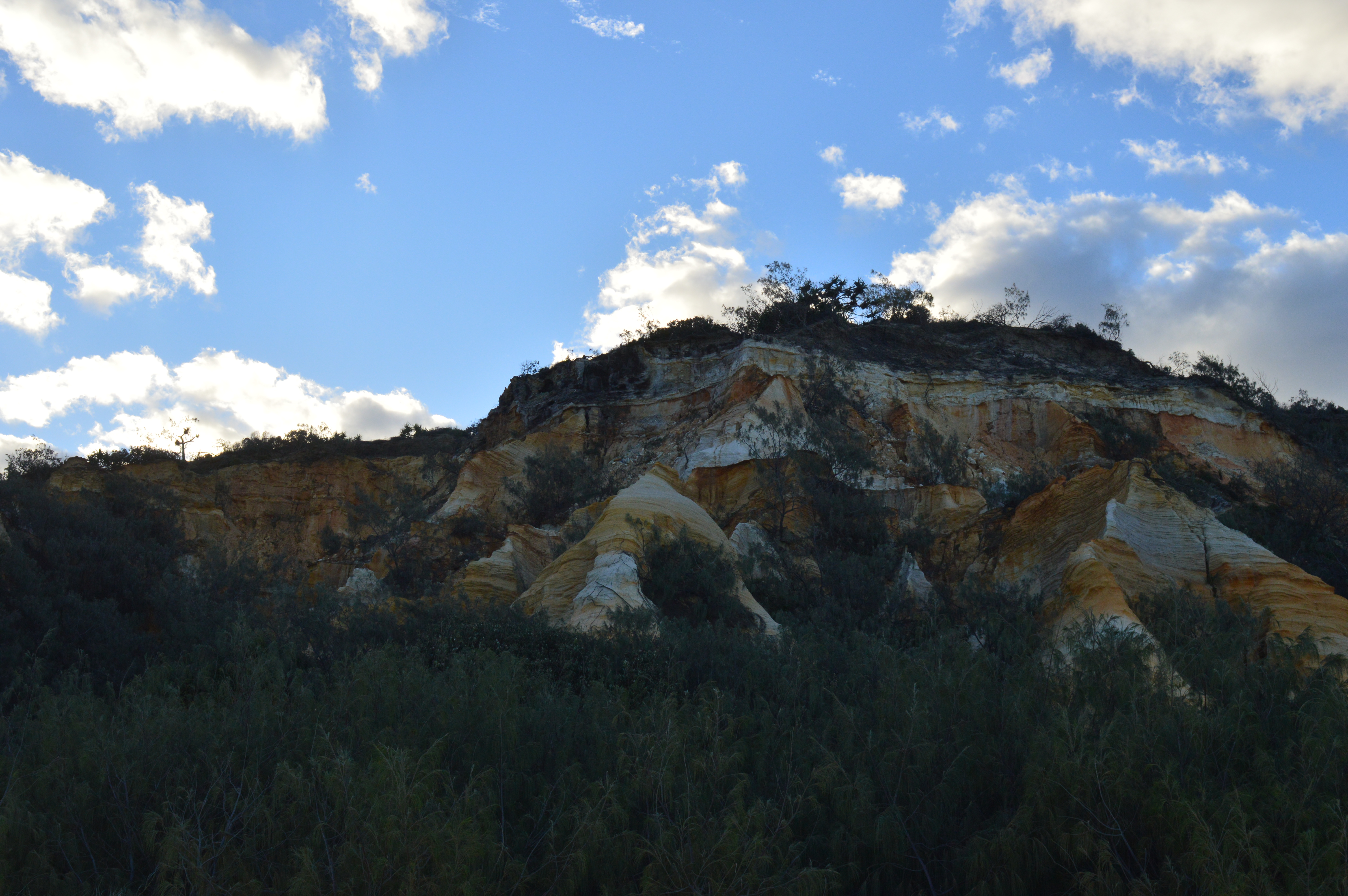
The coloured sands found at Rainbow Gorge, The Cathedrals, The Pinnacles and Red Canyon are examples of the sand being stained over thousands of years due to it conglomerating with clay.[35] Hematite, the mineral pigment responsible for the staining, acts like cement. That allows the steeper cliffs of coloured sand to form. Coffee rock, so-called because when it is dissolved in water it turns the colour of coffee, is found in outcrops along the beaches on both sides of the island.[86]
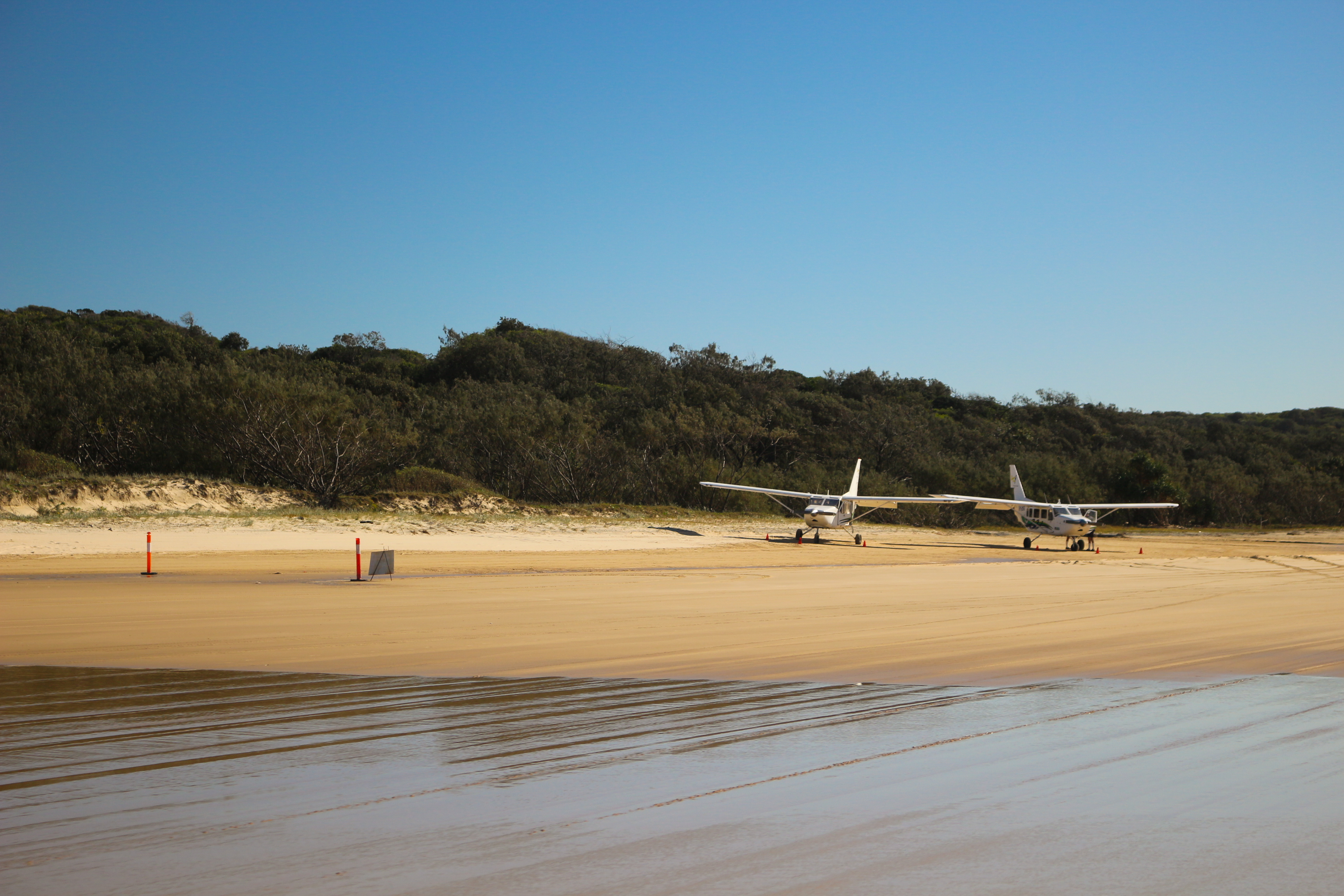
The "75-Mile Beach" (120 km) runs along most of the east coast of Fraser Island. It is officially designated as a main road and is used as a landing strip for planes. Highway rules state that vehicles must give way to aircraft if they are oncoming. Along the beach are the Champagne Pools, Indian Head, the Maheno Wreck, and the outflow of Eli Creek. Exposed volcanic rocks are found at Indian Head, Waddy Point and Middle Rocks,[93] as well as near Boon Boon Creek.[86]
Lakes


Fraser Island has more than 100 freshwater lakes,[94] the second highest concentration of lakes in Australia after Tasmania.[90] The freshwater lakes on the island are some of the cleanest in the world.[6] A popular tourist area, Lake McKenzie, is located inland from the small town of Eurong. It is a perched lake, sitting on top of compact sand and vegetable matter 100 metres (330 ft) above sea level. Lake McKenzie has an area of 150 hectares and is just over 5 metres (16 ft) deep. The beach sand of Lake McKenzie is nearly pure silica. The lakes have very few nutrients and their pH varies, but sunscreen and soaps cause a pollution problem. Fresh water on the island may become stained by organic acids found in decaying vegetation. Because of the organic acids, a pH level as low as 3.7 has been measured in some of the island's perched lakes.[86] The acidity prevents many species from inhabiting the lakes.
Another perched lake on Fraser Island is Lake Boomanjin which, at 200 hectares in size, is the largest perched lake on any sea island in the world.[68] In total there are 40 perched lakes on the island, half of all known lakes of this kind on the planet.[7] Lake Boomanjin is fed by two creeks that pass through a wallum swamp where it collects tannins which tint the water red.[86] Lake Wabby is the deepest lake on the island, at 12 metres (39 ft) in depth, and is also the least acidic, which means it has the most aquatic life of all the lakes.
Some of the lakes on Fraser Island are window lakes, which form when the water table has risen to a point higher than the surrounding land. Most of the valleys on the island have creeks which are fed by springs.[86] Motor boats and jet skis are banned from the lakes on the island.[30]
Climate
Fraser Island has a tropical wet and dry climate (Köppen: Aw); it is generally warm and not subject to extremes in temperature due to the moderating influence of the ocean. Temperatures rarely rise above 33 °C (91 °F) or drop below 7 °C (45 °F) and humidity is consistently high. Rainfall is heaviest during the summer and early autumn, and the annual average is 1,251 mm (49.25 in). Cyclones can be a threat; Cyclone Hamish brushed the island as a category 5 in March 2009, while Cyclone Oswald in January 2013 was significantly weaker at a Category 1. Both storms however caused severe beach erosion, particularly on the island's northern tip.[95] The average annual temperature of the sea ranges from 22 °C (72 °F) between July and September to 27 °C (81 °F) between January and March.[96]
| Climate data for Fraser Island (Sandy Cape Lighthouse), 1991 - 2020 | |||||||||||||
|---|---|---|---|---|---|---|---|---|---|---|---|---|---|
| Month | Jan | Feb | Mar | Apr | May | Jun | Jul | Aug | Sep | Oct | Nov | Dec | Year |
| Record high °C (°F) | 34.2 (93.6) |
35.8 (96.4) |
34.7 (94.5) |
31.4 (88.5) |
28.7 (83.7) |
27.8 (82.0) |
26.5 (79.7) |
27.2 (81.0) |
29.3 (84.7) |
31.8 (89.2) |
33.2 (91.8) |
36.0 (96.8) |
36.0 (96.8) |
| Average high °C (°F) | 29.8 (85.6) |
29.8 (85.6) |
28.9 (84.0) |
27.1 (80.8) |
24.4 (75.9) |
22.4 (72.3) |
21.8 (71.2) |
22.8 (73.0) |
24.9 (76.8) |
26.3 (79.3) |
27.8 (82.0) |
29.1 (84.4) |
26.3 (79.3) |
| Daily mean °C (°F) | 26.2 (79.2) |
26.3 (79.3) |
25.4 (77.7) |
23.7 (74.7) |
21.1 (70.0) |
19.1 (66.4) |
18.2 (64.8) |
19.1 (66.4) |
21.2 (70.2) |
22.6 (72.7) |
24.2 (75.6) |
25.5 (77.9) |
22.7 (72.9) |
| Average low °C (°F) | 22.7 (72.9) |
22.8 (73.0) |
22.0 (71.6) |
20.3 (68.5) |
17.9 (64.2) |
15.8 (60.4) |
14.7 (58.5) |
15.5 (59.9) |
17.5 (63.5) |
19.0 (66.2) |
20.6 (69.1) |
21.9 (71.4) |
19.2 (66.6) |
| Record low °C (°F) | 16.7 (62.1) |
16.1 (61.0) |
14.6 (58.3) |
13.3 (55.9) |
9.6 (49.3) |
6.7 (44.1) |
5.2 (41.4) |
5.6 (42.1) |
9.4 (48.9) |
11.2 (52.2) |
13.9 (57.0) |
16.0 (60.8) |
5.2 (41.4) |
| Average rainfall mm (inches) | 150.3 (5.92) |
157.6 (6.20) |
141.8 (5.58) |
111.0 (4.37) |
127.9 (5.04) |
101.5 (4.00) |
70.1 (2.76) |
53.8 (2.12) |
42.4 (1.67) |
90.7 (3.57) |
62.2 (2.45) |
99.8 (3.93) |
1,209.1 (47.61) |
| Average rainy days (≥ 1.0 mm) | 9.9 | 10.0 | 11.4 | 11.2 | 11.0 | 9.8 | 8.2 | 6.1 | 4.7 | 5.5 | 5.5 | 7.4 | 100.7 |
| Source: Bureau of Meteorology[97] | |||||||||||||
Fauna
Mammals
Estimates of the number of mammal species present on Fraser Island range from 25 to 50.[94][98] Mammals include swamp wallabies, echidnas, ringtail and brushtail possums, sugar gliders, squirrel gliders, phascogales, bandicoots, potoroos, flying foxes and dingoes. The swamp wallaby finds protection from dingos in the swampy areas which have dense undergrowth.[99] There are 19 species of bats which live on or visit the island.[99]
Until 2003, when they were removed by the Environmental Protection Agency,[100] there were a few brumbies (horses) on the island, descendants of Arab stock turned loose for breeding purposes, and joined in 1879 by horses brought over for the logging industry.[101][102]
Dingoes

Dingoes were once common on Fraser Island, but are now decreasing. The island dingoes are reputedly some of the last remaining 'pure' dingoes in Eastern Australia and to prevent cross-breeding, dogs are not allowed on the island. According to DNA-examinations from the year 2004, the island dingoes are "pure".[103] However, skull measurements from the 1990s detected crossbreeds between dingoes and domestic dogs among the population.[104]
Up until 1995, there were no official records of dingoes attacking humans on Fraser Island. In April 2001, a boy named Clinton Gage wandered away from his family and was attacked and killed by several dingoes.[105] More than 120 dingoes were killed by rangers as a result of the incident, though locals believe the number was much greater.[101] After the 2001 attack, four dedicated rangers were allocated dingo management roles and ranger patrols were increased.[106] There are fines for feeding dingoes or leaving food and rubbish out which may attract them.[98]
As of January 2008, the number of dingoes on Fraser Island was estimated to be 120 to 150, and sightings have become less common. A University of Queensland researcher, Nick Baker, claims the island dingoes have adopted unusual behaviour. Rather than hunt in small packs, island dingoes had developed a tolerance for each other and work together in one big hunting pack.[106] Dingo-proof fences, consisting of metals bars across a concrete pit and a 1.8 m high mesh fence were built around nine island settlements in 2008, to keep the dingoes out of the townships.[107]
In March 2010, three separate reports of dingos biting tourists were made.[108] Tourists have been criticised for ignoring advice from park rangers as they try to provoke reactions from dingoes while taking photographs.[108]
As of 2015[update], the number of dingoes on Fraser Island was estimated to be around 180 to 220.[109]
Reptiles and amphibians
There has been a total of 74 different species of reptiles recorded on Fraser Island.[99] 18 species of snakes have been identified with one third of them considered dangerous, including the extremely venomous eastern brown snake.[94] Goannas, snakes, geckos, skinks and frogs are all present on the island. Some frog species have evolved to cope with the acidic waters of lakes and swamps on the island, and are appropriately called acid frogs.[98][102] The island is home to the recently discovered Fraser Island sand skink. Freshwater turtles such as Kreffts river turtle are found in the island's lakes and creeks.
Saltwater crocodiles are exclusively tropical reptiles and usually found in Far North Queensland (several hundred kilometres north-west of Fraser Island), however, occasionally during the warmer season (December through March, when water temperatures reach consistent tropical temperatures) crocodiles may appear in areas in and around the island. During the 2008–2009 summer several crocodiles (one over 4 metres in length) were present in the surrounding ocean.[110] It is thought that these reptiles are seasonal visitors, as they always disappear during the cold months (presumably returning to tropical northern Queensland.) This sort of activity was apparently reported but unverified decades ago (a handful of crocodiles have also historically been observed on very rare occurrences around Brisbane, the Gold Coast and Sunshine Coast during the warmer season) but within recent years has been proven and observed more often. Crocodiles do not breed nor do they appear to have any permanent populations living on the island.
Birds
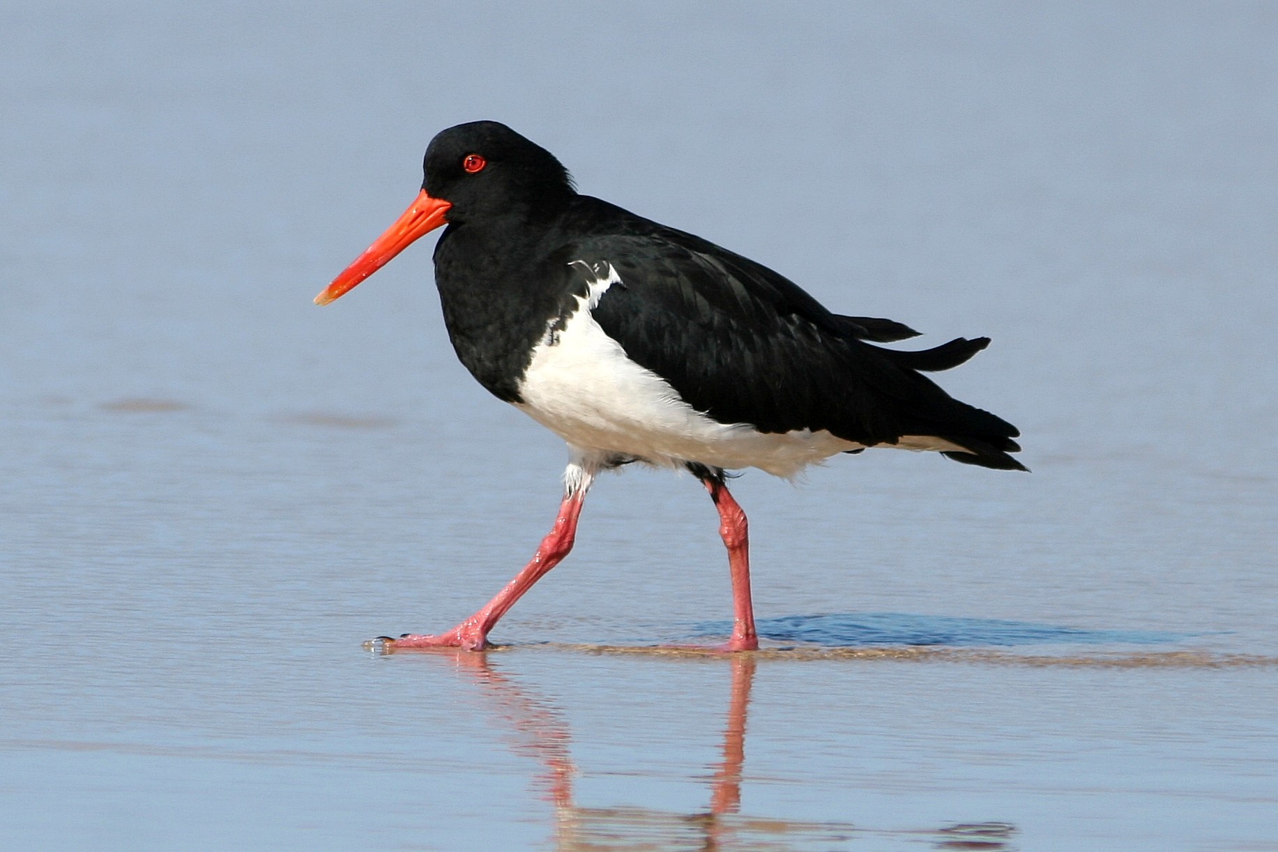
Fraser Island forms part of the Cooloola and Fraser Coast Important Bird Area (IBA).[111] There are over 350 different species of birds on the island.[7] Birds of prey include sea eagles, peregrine falcon, osprey and kites. Other common birds include pelicans, terns, honeyeaters, gulls, kingfishers, kookaburra, owls, doves, thornbills, ducks, brolgas, and cockatoos. The island is visited by 20 species of migratory wader birds from as far afield as Siberia.[99] The island provides habitat for 22 different species of gull and tern, four species of falcon and six species of kingfisher.[112] A rare bird on the island is the eastern ground parrot, already extinct in some parts of Australia.[101][102]

Other
Cetaceans, such as humpback whales and some species of dolphins are frequent visitors to the area. Dugongs and sea turtles can also be found in surrounding waters.[98] Great white, bull and tiger sharks can be found, with the latter species sometimes approaching fishermen wading in the surf.[98] Mud crabs are found on the western side of the island near mangrove-lined estuaries.[68] 24 freshwater fish species are found in the island's lakes.[94]
There has been 300 species of ants recorded on Fraser Island.[99] Long finned eels and giant earthworms are also found on the island.
Flora
The flora of Fraser Island is diverse. More than 865 species of plants grow on the island.[86] It is the only place on earth where tall rainforest grows in sand.[98] The island contains the largest extent of wallum heath remnants in Queensland. In Pile Valley, 1,000-year-old rough-barked satinays are found.[98] Despite being logged the kauri pines dominate in some areas. Scribbly gums, red gums, piccabeen palms, blue quandong, brush box and pandanus all grow on the island. Along the coast, the foredunes are dominated by salt-tolerant species which includes pigface, goats foot vine and beach spinifex.[35] Spinifex sericeus is an important foundation species. Decayed matter from this dune grass breaks down in the sand, providing vital nutrients for other plant species, such as the beach oak.[86] The rare Angiopteris evecta, a species of fern that has the largest fronds in the world, grows on the island.[94] The southwest coast is dominated by mangroves.[86] Persoonia prostrata was a shrub native to the island which is now extinct.
As one travels from east to west across Fraser Island, the dune age increases. This leads to the progressive maturing of vegetation in the same direction, except for some areas along the western coast where soil leaching has decreased the nutrient soil layer to a depth beyond the reach of plant roots.[99] Each lake on the island is surrounded by concentric vegetation zones. Typically these zones range from rushes in the shallows, then a mix of pioneer species on the beaches, through to sedges, heath, paperbarks, shrubs and finally eucalypt or banksia woodlands.[99]
Administration

Fraser Island is part of the local government area Fraser Coast Region, which was created in March 2008 as a result of the report of the Local Government Reform Commission released in July 2007. Before the local government reorganisation, the island was split up evenly between the City of Hervey Bay (northern part) and the City of Maryborough (southern part).
In 1971, the northern half of Fraser Island was declared a national park.[35] Now almost all of the island is included in the Great Sandy National Park, which is administered by Queensland's Environmental Protection Agency. This was extended in 1992 when heritage listing was granted. Except for a few small urban areas the island is protected by a Wild Rivers declaration.[113]
Domestic dogs are not permitted on Fraser Island and fines can be given for non-compliance. The ban, first applied in 1981,[105] is imposed so that the island's dingo population is not exposed to diseases.[114]
In 2010, the management of the park, particularly the treatment of dingoes by the Department of Environment and Resource Management was called into question by Glen Elmes in the Queensland Parliament.[115] Camp grounds are sometimes closed so as to reduce human contact with dingo populations.[108]
Heritage listings
Fraser Island has a number of heritage-listed sites, including:
- North end of island: Sandy Cape Light[85]
- Protected Area: SS Marloo[116]
The island was placed on the Australian National Heritage List on 21 May 2007.[7]
Tourism


Fraser Island is one of Queensland's most popular islands for tourists, who can reach the island by ferry from Hervey Bay or Rainbow Beach, which takes approximately 50-minutes.[117] Estimates of the number of visitors to the island each year range from 350,000 to 500,000.[105][118] The chance of seeing a dingo in its natural setting is one of the main reasons people visit the island.[105] The use of boardwalks and marked tracks by visitors is encouraged to reduce erosion.[30]
Urinating tourists have created environmental problems in Fraser Island lakes and on coastal dunes. The foredunes are used as a toilet by bush campers, who are estimated to number 90,000 each year.[118] Many of the perched lakes have no outflow or inflow which exacerbates the problem. Water quality in some lakes is being affected by storm water run-off from dune roads, and by swimmers' use of sunscreen.
In April 2009, a vehicle overturned on the beach after being hit by a wave. Two backpackers were killed in the accident. Following the incident speed limits on the beach were reduced from 100 km/h to 80 km/h, and from 40 km/h to 30 km/h inland.[119] Everyone who hires a vehicle on the island from an organisation accredited by the Fraser Coast 4WD Operators Association must attend a one-hour-long briefing on vehicle safety.
"Central Station", which was formerly the hub of the forestry industry when there was logging on Fraser Island, is now a popular tourist destination. Some of the rarest ferns grow in the rainforest near the location.
Access
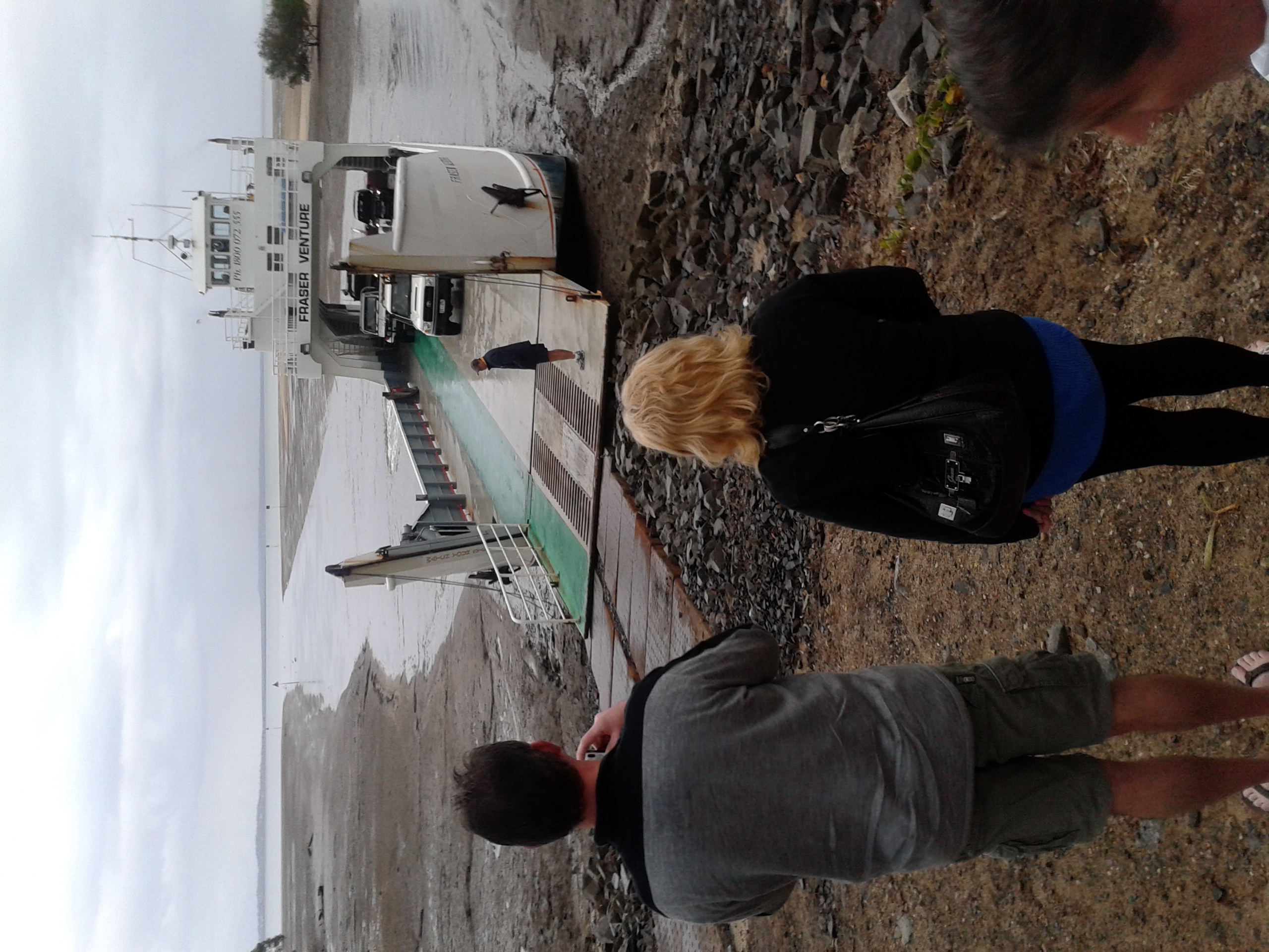
The island can be reached by a ferry from River Heads (South of Hervey Bay) to Kingfisher Bay and Wanggoolba Creek or Inskip Point to north of Rainbow Beach to Hook Point, or by chartered flight from Sunshine Coast Airport.[120]
A four-wheel drive is required for all landings (except Kingfisher Bay), and travel on the island (except within the Kingfisher Bay Resort). A permit is required for vehicles and is obtainable on-line from DERM and several outlets at Rainbow Beach. Several firms provide four-wheel drive vehicles for hire.[121] Tour buses travel the island as well as several kinds of self-drive tours departing regularly from Hervey Bay, Rainbow Beach and Noosa.[122]
Angling
Tailor is one of the more common species sought by anglers on Fraser Island and along the Queensland coast. Other fish caught on the eastern coast include jewfish, golden trevally and surf bream, while whiting, flathead and surf bream prefer the calmer western waters.[68] Pilchards, bloodworms, yabbies, pipi and sandworms can all be used for bait. Fishing is banned in the island's freshwater creeks and lakes.[99] There is an annual seasonal fishing closure between the beginning of 1 August to the end of 29 September, for eastern foreshore waters as well as waters within 400 m out to sea from the eastern shore and between 400 m north of Waddy Point and 400 m south of Indian Head. The fishing closure prohibits the taking of fin fish only and anglers are still allowed to hand collect worms and pipis during the closure.[123]
Camping
There are many campgrounds on Fraser Island with varying amenities and access. The main camping areas are: Dundubara Campground, Cathedrals on Fraser,[124] Waddy Point campground, Central Station Tent Sites, Waddy Beach (tent only campsites), Cornwells Break (large group site), One Tree Rocks camp zone (Eurong-One Tree Rocks), however there are others. Permits are required for camping and also for vehicle access.[125]
Hiking
There are various possibilities for overnight hiking on the island. Most notable is the 90 km long Fraser Island Great Walk. A shorter hike would be for example to start in Kingfisher Bay (ferry drop off) and head to Lake McKenzie, stay there for one night, and then hike back.[citation needed]
See also
- Geography of Queensland
- Great Sandy Biosphere Reserve
- John Sinclair (environmentalist)
- Clifford Harry Thompson, geomorphologist, influential Fraser Island researcher
- List of islands of Australia
- Tourism in Australia
References
- Australian Bureau of Statistics (27 June 2017). "Fraser Island (SSC)". 2016 Census QuickStats. Retrieved 20 October 2018.
- "Fraser Island – island in the Fraser Coast Region (entry 47533)". Queensland Place Names. Queensland Government. Retrieved 14 October 2021.
- UNESCO World Heritage Centre (2007). "Fraser Island". Australia. Archived from the original on 8 March 2007. Retrieved 14 January 2007.
- "World Heritage Area renamed K'gari after long campaign by Butchulla people". Ministerial Media Statements. 20 September 2021. Archived from the original on 21 September 2021. Retrieved 21 September 2021.
 Text may have been copied from this source, which is available under a Attribution 4.0 International (CC BY 4.0) Archived 16 October 2020 at the Wayback Machine licence.
 - Department of the Environment, Water, Heritage and the Arts (2008). "Fraser Island – World Heritage – More information". Australia. Archived from the original on 18 May 2008. Retrieved 5 June 2008.
{{cite web}}: CS1 maint: multiple names: authors list (link) - "Fraser Island". Places. Vol. 218, no. 3. The National Geographic Society. 1 September 2010. Archived from the original on 19 August 2010. Retrieved 24 August 2010.
- "World Heritage Places - Fraser Island". Federal Department of Agriculture, Water and the Environment. 2006. Archived from the original on 18 May 2008. Retrieved 7 February 2021.
- Hadwen, Wade L.; Arthington, Angela H.; Mosisch, Thorsten D. (March 2003). "The impact of tourism on dune lakes on Fraser Island, Australia". Lakes and Reservoirs. 8 (1): 15–26. doi:10.1046/j.1440-1770.2003.00205.x. hdl:10072/6102. Archived from the original on 17 November 2021. Retrieved 17 November 2021.
In view of the increasing tourism to Fraser Island, Queensland, a tourist pressure index (TPI) was developed to assess the potential threat of tourism to 15 of the most accessible dune lakes on the island.
- Buchanan, Kallee; Kay, Ross; Ford, Elaine (24 October 2014). "Native title rights granted for Qld's Fraser Island". ABC News. Archived from the original on 22 January 2021. Retrieved 9 February 2021.
- "Paradise found as World Heritage Area reinstates traditional name". NITV. 20 September 2021. Archived from the original on 20 September 2021. Retrieved 20 September 2021.
- "World Heritage Places - K'gari (Fraser Island)". Australian Government. Archived from the original on 2 October 2021. Retrieved 14 October 2021.
- Bligh, Anna (10 June 2009). "Premier Unveils Queensland's 150 Icons". Queensland Government. Archived from the original on 24 May 2017. Retrieved 24 May 2017.
- Office of the Inspector-General Emergency Management (Queensland) (2021). K'gari (Fraser Island) Bushfire Review (PDF) (Report). Report 1: 2020-21. State of Queensland (Inspector-General Emergency Management). p. 5. ISSN 2204-969X. Archived (PDF) from the original on 6 October 2021. Retrieved 21 September 2021.
Text may have been copied from this source, which is available under a Attribution 4.0 International (CC BY 4.0) Archived 16 October 2020 at the Wayback Machine licence.
- Archibald-Binge, Ella (24 April 2017). "Fraser Island national park renamed K'gari by Traditional Owners". NITV. Archived from the original on 29 September 2021. Retrieved 4 December 2020.
- "Return to paradise for K'gari Fraser Island". ABC News. Australian Broadcasting Corporation. 20 September 2021. Archived from the original on 21 September 2021. Retrieved 21 September 2021.
- Quaill, Avril (2000). "World of Dreamings: Traditional and modern art of Australia". National Gallery of Australia. Exhibition at the State Hermitage Museum, St Petersburg and the National Gallery of Australia, 2000, featuring the work of Fiona Foley. Archived from the original on 21 September 2021. Retrieved 19 September 2021.
- "Thoorgine Island". Tharunka. Vol. 36, no. 10. New South Wales, Australia. 13 August 1990. p. 4. Archived from the original on 14 July 2022. Retrieved 21 September 2021 – via National Library of Australia.
- "K'gari (Fraser Island), Great Sandy National Park". Department of Environment and Science (Qld.). 27 March 2020. Archived from the original on 30 December 2020. Retrieved 4 December 2020.
- "Fraser Island renamed K'gari". qorf.org.au. Outdoors Queensland. 24 April 2017. Archived from the original on 23 September 2021. Retrieved 4 December 2020.
- Horton, David R. (1996). "Map of Indigenous Australia". AIATSIS. Archived from the original on 4 October 2020. Retrieved 20 September 2021.
- "Fraser Island". Places. Vol. 218, no. 3. The National Geographic Society. 1 September 2010. Archived from the original on 19 August 2010. Retrieved 24 August 2010.
- "Fraser Island – Queensland – Australia – Travel". The Age. The Age Company. 8 February 2004. Archived from the original on 6 November 2012. Retrieved 5 October 2010.
- "The Stirling Castle". The Sydney Gazette And New South Wales Advertiser. Vol. XXXVI, no. 3074. New South Wales, Australia. 1 February 1838. p. 2. Archived from the original on 5 August 2022. Retrieved 5 August 2022 – via National Library of Australia.
- FraserIsland.net (2006). "Fraser Island European History". Archived from the original on 7 December 2006. Retrieved 2 February 2007.
- "Queensland Shipwrecks, including Central and Southern Great Barrier Reef". Queensland. The Encyclopedia of Australian Shipwrecks. Archived from the original on 2 October 2009. Retrieved 10 January 2007.
- Chloe Sargeant, NITV (2017). "Miranda Otto on 'K'gari', and correcting Eliza Fraser's 'remarkably silly' story". Archived from the original on 3 August 2021. Retrieved 4 December 2020.
- "Indigenous languages map of Queensland". State Library of Queensland. 2020. Archived from the original on 2 October 2020. Retrieved 21 January 2020.
- Walk About Australian Travel Guide. "Fraser Island". Fairfax Digital. Archived from the original on 30 December 2006. Retrieved 2 February 2007.
- FraserIsland.net (2006). "Fraser Island Aboriginal History". Archived from the original on 7 December 2006. Retrieved 14 January 2007.
- "Australias World Heritage Places: Fraser Island Information Sheet" (PDF). Archived from the original (PDF) on 15 March 2011. Retrieved 28 September 2010.
- Australian Broadcasting Corporation (2014). "Fraser Island: Native title rights granted to Indigenous people by Federal Court". Australian Broadcasting Corporation. Archived from the original on 30 October 2014. Retrieved 2 November 2014.
- Evans, Raymond (2007). A History of Queensland. Cambridge University Press. p. 19. ISBN 978-0521876926. Archived from the original on 27 June 2014. Retrieved 14 September 2020.
- "Fraser Coast: History". Fraser Coast Regional Council. Archived from the original on 1 October 2010. Retrieved 11 September 2010.
- A Voyage to Terra Australis. 1814.
- "Great Sandy National Park – Nature, Culture and History". Department of Environment and Resource Management. Archived from the original on 27 November 2012. Retrieved 23 January 2010.
- "Fraser Island – Queensland – Australia – Travel". The Age. The Age Company. 8 February 2004. Archived from the original on 6 November 2012. Retrieved 5 October 2010.
- "THE COAST BLACKS". The Maitland Mercury And Hunter River General Advertiser. Vol. VI, no. 372. New South Wales, Australia. 26 January 1848. p. 4. Archived from the original on 14 July 2022. Retrieved 29 December 2017 – via National Library of Australia.
- "WIDE BAY". The Sydney Morning Herald. Vol. XXIX, no. 4189. New South Wales, Australia. 19 October 1850. p. 5. Archived from the original on 14 July 2022. Retrieved 29 December 2017 – via National Library of Australia.
- "DOMESTIC INTELLIGENCE". The Moreton Bay Courier. Vol. VI, no. 273. Queensland, Australia. 6 September 1851. p. 2. Retrieved 29 December 2017 – via National Library of Australia.
- Skinner, L E (1975). Police of the Pastoral Frontier. UQP. pp. 46–47.
- "FRASER'S ISLAND". The Sydney Morning Herald. Vol. XXXII, no. 4583. New South Wales, Australia. 22 January 1852. p. 2. Archived from the original on 2 October 2020. Retrieved 29 December 2017 – via National Library of Australia.
- Skinner, L E (1975). Police of the Pastoral Frontier. UQP. pp. 64–66.
- FRASER ISLAND MASSACRE Vrai ou Faux by Paul Dillon ISBN 9781922449108 Connor Court Publishing.
- Halloran, Arthur E. "Letters to Colonial Secretary relating to Moreton Bay and Queensland" (PDF). Archived (PDF) from the original on 29 December 2017. Retrieved 28 December 2017.
- "MARYBOROUGH". The Moreton Bay Courier. Vol. XIV, no. 795. Queensland, Australia. 26 October 1859. p. 2. Archived from the original on 14 July 2022. Retrieved 29 December 2017 – via National Library of Australia.
- "MARYBOROUGH". The Moreton Bay Courier. Vol. XIV, no. 830. Queensland, Australia. 21 February 1860. p. 4. Archived from the original on 14 July 2022. Retrieved 28 December 2017 – via National Library of Australia.
- "A FEMALE AND TWO CHILDREN ON FRASER'S ISLAND". The Sydney Morning Herald. Vol. XL, no. 6614. New South Wales, Australia. 19 August 1859. p. 4. Archived from the original on 14 July 2022. Retrieved 29 December 2017 – via National Library of Australia.
- "THE FRASER ISLAND GIRLS". The Brisbane Courier. 22 August 1898. p. 6. Archived from the original on 14 July 2022. Retrieved 4 December 2020.
- "COLONIAL PARLIAMENT". The Sydney Morning Herald. Vol. XL, no. 6666. New South Wales, Australia. 19 October 1859. p. 3. Archived from the original on 14 July 2022. Retrieved 29 December 2017 – via National Library of Australia.
- "FRAUD, DECEPTION, AND INJUSTICE PRACTISED UPON THE BLACKS OF FRAZER'S ISLAND". The Sydney Morning Herald. Vol. XLI, no. 6870. New South Wales, Australia. 14 June 1860. p. 5. Archived from the original on 14 July 2022. Retrieved 29 December 2017 – via National Library of Australia.
- "THE WHITE GIRLS RESCUED FROM FRASER'S ISLAND". Empire. No. 2, 698. New South Wales, Australia. 18 May 1860. p. 2. Archived from the original on 14 July 2022. Retrieved 29 December 2017 – via National Library of Australia.
- "Ermology". The Queenslander. Queensland, Australia. 1 October 1898. p. 650 (Unknown). Archived from the original on 14 July 2022. Retrieved 9 May 2020 – via Trove.
- "SOUTHERN QUEENSLAND". Queensland Country Life. Vol. III, no. 28. 1 June 1902. p. 14. Archived from the original on 14 July 2022. Retrieved 4 January 2018 – via National Library of Australia.
- "WHITE CLIFFS AFFAIR". The Brisbane Courier. Vol. LIII, no. 12, 257. Queensland. 26 April 1897. p. 2. Archived from the original on 14 July 2022. Retrieved 4 January 2018 – via National Library of Australia.
- "THE WHITE CLIFFS AFFAIR". Maryborough Chronicle, Wide Bay and Burnett Advertiser. No. 7, 665. Queensland. 31 May 1897. p. 2. Archived from the original on 14 July 2022. Retrieved 4 January 2018 – via National Library of Australia.
- "Brisbane". Maryborough Chronicle, Wide Bay and Burnett Advertiser. No. 8, 492. Queensland. 30 January 1900. p. 2. Archived from the original on 14 July 2022. Retrieved 4 January 2018 – via National Library of Australia.
-
 This Wikipedia article incorporates text from Dr Fiona Foley - Monica Clare Research Fellow (3 November 2020) published by the State Library of Queensland under CC-BY licence, accessed on 1 June 2022.
- Evans, Raymond (1999). Fighting Words: Writing about race. St Lucia: UQP. pp. 123–143. Archived from the original on 4 January 2018. Retrieved 4 January 2018.
- "MAGISTERIAL INQUIRY". Maryborough Chronicle, Wide Bay and Burnett Advertiser. No. 8, 906. Queensland. 30 May 1901. p. 2. Archived from the original on 14 July 2022. Retrieved 4 January 2018 – via National Library of Australia.
- "THE ABORIGINAL STATION AT BOGIMBAH". Darling Downs Gazette. Vol. XLIII, no. 9, 847. Queensland, Australia. 25 July 1901. p. 2. Archived from the original on 14 July 2022. Retrieved 4 January 2018 – via National Library of Australia.
- "FRASER ISLAND MISSION". The Brisbane Courier. Vol. LXII, no. 14, 928. Queensland, Australia. 15 November 1905. p. 3. Archived from the original on 14 July 2022. Retrieved 4 January 2018 – via National Library of Australia.
- "ABANDONING FRASER ISLAND MISSION". Queensland Times, Ipswich Herald and General Advertiser. Vol. XLV, no. 6771. Queensland. 28 June 1904. p. 3. Archived from the original on 14 July 2022. Retrieved 4 January 2018 – via National Library of Australia.
- "LEGISLATIVE ASSEMBLY". The Telegraph. No. 10235. Queensland. 6 September 1905. p. 4. Archived from the original on 14 July 2022. Retrieved 4 January 2018 – via National Library of Australia.
- "Fraser Island Again". Truth. No. 243. Brisbane. 25 September 1904. p. 8. Archived from the original on 5 August 2022. Retrieved 4 January 2018 – via National Library of Australia.
- "ABORIGINAL NEWS". The Queenslander. No. 2123. 17 November 1906. p. 29. Archived from the original on 5 August 2022. Retrieved 4 January 2018 – via National Library of Australia.
- "MAGISTERIAL ENQUIRY". Maryborough Chronicle, Wide Bay and Burnett Advertiser. Vol. IV, no. 177. Queensland, Australia. 7 April 1864. p. 2. Archived from the original on 5 August 2022. Retrieved 29 December 2017 – via National Library of Australia.
- Huth, John; Holzworth, Peter (2005), "Araucariaceae in Queensland", in Dargavel, John (ed.), Araucarian Forests, Australia and New Zealand forest histories, vol. 2, Australian Forest History Society, ISBN 0-9757906-1-7, ISSN 1832-8156, archived from the original (PDF) on 13 May 2013, retrieved 23 October 2012
- Hema Maps (1997). Discover Australia's National Parks. Milsons Point, New South Wales: Random House Australia. pp. 174–177. ISBN 1-875992-47-2.
- "History of FIDO" (PDF). Fraser Island Defenders Organisation. Archived (PDF) from the original on 9 April 2013. Retrieved 4 April 2013.
- FraserIsland.net (2006). "Fraser Island European History". Archived from the original on 7 December 2006. Retrieved 2 February 2007.
- Lines, William J. (1991). Taming the Great Southern Land. Los Angeles: University of California Press. pp. 237–238. ISBN 0-520-07830-6.
- "Defending Fraser Island". Q-Album. Queensland Government. Archived from the original on 20 September 2021. Retrieved 20 September 2021.
- Mike Steketee (1 January 2007). "Move in New York to stop sand-mining ban". The Australian. News Limited. Archived from the original on 10 October 2010. Retrieved 28 September 2010.
- Lachie Campbell; Gillan Gout (12 June 2003). "The Maheno – the story of a famous shipwreck". ABC Wide Bay Queensland. Archived from the original on 4 April 2005. Retrieved 14 January 2007.
- "Nauru Island". Asia and Oceania. Encyclopedia of the Nations. 2006. Archived from the original on 24 February 2011. Retrieved 11 February 2007.
- "United Nations Trusteeship Council". International Organization. University of Wisconsin Press. 18 (4): 838–839. Autumn 1964. doi:10.1017/s0020818300025352. JSTOR 2705534. S2CID 249402265.
- "Fraser Island". The Sydney Morning Herald. 8 February 2004. Archived from the original on 11 February 2007. Retrieved 11 February 2007.
- "NAURU AND RACIAL PREJUDICE". The Canberra Times. Vol. 39, no. 10, 943. Australian Capital Territory, Australia. 5 September 1964. p. 2. Archived from the original on 14 July 2022. Retrieved 4 January 2018 – via National Library of Australia.
- Australian Bureau of Statistics (31 October 2012). "Fraser Island (State Suburb)". 2011 Census QuickStats. Retrieved 14 July 2013.
- Binnie, Kerrin; and, Staff (14 November 2020). "Fraser Island bushfire closing in on township after blaze started by illegal campfire". ABC News. Australian Broadcasting Corporation. Archived from the original on 7 May 2021. Retrieved 6 February 2021.
- Stewart, Jessica; and, Staff (7 December 2020). "Fraser Island residents told to 'leave immediately' as bushfire threatens town and interstate resources join firefighting effort". ABC News. Australian Broadcasting Corporation. Archived from the original on 21 January 2021. Retrieved 6 February 2021.
Strong winds and temperatures of up to 32 degrees Celsius are predicted on Fraser Island again today as a heatwave continues to scorch parts of Queensland. – ABC News
- Van Vonderen, Jessica; and, Staff (13 December 2020). "South-east Queensland braces for flooding after wet weekend". ABC News. Australian Broadcasting Corporation. Archived from the original on 9 March 2021. Retrieved 6 February 2021.
- Hegarty, Nicole (14 December 2020). "K'gari-Fraser Island to reopen as weekend rain contains bushfire that has burned since October". ABC Wide Bay. Australian Broadcasting Corporation. Archived from the original on 11 February 2021. Retrieved 6 February 2021.
- Gramenz, Emilie (3 December 2020). "Fraser Island bush will regenerate despite fire scorching half of World Heritage-listed site, scientists say". ABC News (Australia). Australian Broadcasting Corporation. Archived from the original on 6 December 2020. Retrieved 6 February 2021.
- "Sandy Cape Lightstation (entry 601712)". Queensland Heritage Register. Queensland Heritage Council. Retrieved 7 July 2013.
- Meyer, Peter (2004). Fraser Island Australia. Hong Kong: Printing Express Limited. ISBN 0-646-44208-2.
- "Queensland Globe". State of Queensland. Retrieved 14 October 2021.
- "Fraser Island – locality in the Fraser Coast Region (entry 47392)". Queensland Place Names. Queensland Government. Retrieved 18 October 2021.
- "Eurong – locality in the Fraser Coast Region (entry 46648)". Queensland Place Names. Queensland Government. Retrieved 18 October 2021.
- FraserIsland.net (2006). "Fraser Island Lakes and Creeks". Archived from the original on 4 January 2007. Retrieved 2 January 2007.
- "Fraser Island's Fens" (PDF). Fraser Island Defenders Organisation. Archived (PDF) from the original on 20 February 2011. Retrieved 23 January 2011.
- Ron Boyd; Ian Goodwin; Kevin Ruming; Shannon Davies (August 2004). "River of Sand – A Geological Perspective on the Evolution of Fraser Island and Surrounding Seabed: Abstract". Earth and Ocean Science Group. University of Newcastle. Archived from the original on 10 May 2013. Retrieved 10 September 2010.
- Cohen, B. E.; Vasconcelos, P. M.; Knesel, K. M. (February 2007). "40 Ar/ 39 Ar constraints on the timing of Oligocene intraplate volcanism in southeast Queensland ∗". Australian Journal of Earth Sciences. 54 (1): 105–125. Bibcode:2007AuJES..54..105C. doi:10.1080/08120090600981483. ISSN 0812-0099. S2CID 128834679. Archived from the original on 14 July 2022. Retrieved 16 March 2021.
- "Fraser Island". Fraser Island Research and Learning Centre. University of the Sunshine Coast. Archived from the original on 18 February 2011. Retrieved 28 September 2010.
- Katerine Spackman (16 March 2009). "Erosion creates Fraser Is access uncertainty". ABC News. Australian Broadcasting Corporation. Archived from the original on 2 September 2009. Retrieved 16 March 2009.
- "Fraser, QLD ocean water temperature today. Australia". SeaTemperature.info. Archived from the original on 8 July 2018. Retrieved 7 February 2021.
- "Monthly climate statistics: Sandy Cape Lighthouse (1991-2020)". Climate statistics for Australian locations. Bureau of Meteorology. Archived from the original on 7 December 2021. Retrieved 7 December 2021.
- Explore Queensland's National Parks. Prahran, Victoria: Explore Australia Publishing. 2008. pp. 24–27. ISBN 978-1-74117-245-4.
- Hinchliffe, David; Julie Hinchliffe (2006). Explore Fraser Island. Robe, South Australia: Great Sandy Publications. pp. 41–59. ISBN 0-9758190-0-3.
- Wild horses to be removed from Fraser Island Archived 20 February 2011 at the Wayback Machine. 10 August 2003. ABC News Online. Australian Broadcasting Corporation.
- David Kidd (2005). "Fraser Island's wildlife". About Fraser Island. Archived from the original on 13 January 2007. Retrieved 3 January 2007.
- FraserIsland.net (2006). "Fraser Island Wildlife". Archived from the original on 4 January 2007. Retrieved 6 January 2007.
- Jonica Newby (31 March 2005). "Last of the Dingoes". Catalyst. Australian Broadcasting Corporation. Archived from the original on 23 April 2009. Retrieved 8 May 2009.
- P.F. Woodall; P. Pavlov; K.L. Twyford (1996). "Dingoes in Queensland, Australia: skull dimensions and the identity of wild canids". CSIRO Publishing. Archived from the original on 30 April 2009. Retrieved 8 May 2009.
- Nick Alexander (19 October 2009). "Concerns heightening for Fraser Island's dingoes". ScienceAlert. Archived from the original on 6 July 2011. Retrieved 12 September 2010.
- "Dingo superpack on Fraser Island". The Age Company. 30 August 2004. Archived from the original on 28 June 2011. Retrieved 13 September 2010.
- Lou Robson (4 May 2008). "Fraser Island fence fails to keep dingoes out". The Sunday Mail. Queensland Newspapers. Archived from the original on 18 April 2012. Retrieved 13 September 2010.
- Brian Williams (15 March 2010). "Tourists' behaviour going to the dogs". Courier Mail. Queensland Newspapers. Archived from the original on 18 March 2010. Retrieved 12 September 2010.
- "The last of the pure dingoes". Australian Broadcasting Corporation. 2 April 2015. Archived from the original on 8 April 2015. Retrieved 27 April 2015.
- "Fraser Island becoming a crocodile hot spot". The Australian. News Limited. 27 December 2008. Archived from the original on 16 January 2009. Retrieved 14 July 2013.
- "IBA: Cooloola and Fraser Coast". Birdata. Birds Australia. Archived from the original on 6 July 2011. Retrieved 16 June 2011.
- "Archived copy" (PDF). Archived (PDF) from the original on 14 February 2017. Retrieved 13 February 2017.
{{cite web}}: CS1 maint: archived copy as title (link) - "Fraser Wild River: Declaration 2007" (PDF). Department of Resources and Water. Archived from the original (PDF) on 15 March 2011. Retrieved 10 September 2010.
- Jackson Vernon (30 August 2010). "Call to up domestic dog fines on Fraser Island". ABC News Online. Australian Broadcasting Corporation. Archived from the original on 4 November 2010. Retrieved 12 September 2010.
- Arthur Gorrie (2 September 2010). "Claims of Fraser Island 'cover-up'". Gympie Times. APN News & Media. Archived from the original on 6 July 2011. Retrieved 12 September 2010.
- "Protected Area - SS Marloo (entry 800001)". Queensland Heritage Register. Queensland Heritage Council. Retrieved 7 July 2013.
- Alchin, Jessica (21 October 2020). "The Weekender: Fraser Island, Queensland". Hunter and Bligh. Archived from the original on 25 November 2020. Retrieved 2 December 2020.
- Brian Williams (7 August 2009). "Fraser Island one big toilet". Courier Mail. Queensland Newspapers. Archived from the original on 18 March 2010.
- Cosima Marriner (21 December 2009). "Inexperience and thrill-seeking a lethal mix on Fraser Island". The Age. Fairfax Media. Archived from the original on 27 December 2009.
- FraserIsland.net (2006). "Fraser Island General Access". Archived from the original on 4 January 2007.
- FraserIsland.net (2006). "Fraser Island 4WD and Permits". Archived from the original on 4 January 2007. Retrieved 2 January 2007.
- "Fraser Island Station" (PDF). Archived (PDF) from the original on 6 April 2016. Retrieved 3 September 2016.
- Closed waters in tidal waters, 1 January 2013, archived from the original on 29 September 2021, retrieved 29 September 2021
- "Cathedrals on Fraser | Fraser Island Accommodation & Camping". Cathedrals on Fraser. Archived from the original on 24 January 2021. Retrieved 6 February 2021.
- "Fraser Island Camping". 2010. Archived from the original on 17 February 2011.
External links
- Fraser Island From the Air Archived 24 April 2011 at the Wayback Machine
- Official Website of the Department of Environment and Resource Management for more information and camping permits
- World heritage listing for K'gari
- Great Sandy Biosphere
- University of Queensland: Queensland Places: Fraser Island
- Satellite image of S.S. Maheno from Google Maps
- Fraser Island Blazes NASA Earth Observatory
| Authority control |
|
|---|
На других языках
[de] Fraser Island
Fraser Island (oder auch K'gari bzw. Great Sandy Island genannt) ist eine zum Verwaltungsgebiet Fraser Coast Region im australischen Bundesstaat Queensland gehörende Insel. Mit einer Fläche von 1840 Quadratkilometer ist sie die größte Sandinsel der Welt. Sie liegt etwa 190 Kilometer nördlich von Brisbane vor der Ostküste Australiens.- [en] Fraser Island
[es] Isla Fraser
La isla Fraser, K'Gari en el idioma batjala, es la isla de arena más grande del mundo con 1630 km². Fue inscrita como Patrimonio de la Humanidad por la Unesco en el año 1992. Está bajo la administración tanto de la ciudad de Maryborough como de la ciudad de Hervey Bay City Council.[fr] Île Fraser
L'île Fraser (en anglais : Fraser Island), située à proximité de la côte orientale du Queensland, en Australie, est la plus grande île de sable du monde avec une superficie de 1 840 km2, une longueur de 123 km, une largeur d'environ 25 km et un point culminant atteignant 260 m d'altitude. Le sable s'accumule le long de cette portion de la côte du Queensland pendant quelque 750 000 ans, en partie parce que le soubassement volcanique constitue une sorte de barrage naturel pour les sédiments charriés vers le littoral oriental par un puissant courant.[it] Isola di Fraser
L'isola di Fraser (in lingua aborigena locale K'gari, in inglese Fraser Island) è la più grande isola di sabbia al mondo, con una superficie di 1.840 km². Nel 1992 è stata inserita tra i patrimoni dell'umanità dell'UNESCO. È amministrata dal Fraser Coast Regional Council.[ru] Фрейзер (остров)
Фре́йзер[2] (англ. Fraser Island или Great Sandy Island) — песчаный остров у восточного побережья Австралии.Другой контент может иметь иную лицензию. Перед использованием материалов сайта WikiSort.org внимательно изучите правила лицензирования конкретных элементов наполнения сайта.
WikiSort.org - проект по пересортировке и дополнению контента Википедии