geo.wikisort.org - Island
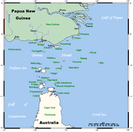
The Prince of Wales Island, or Muralag, is an island of the Torres Strait Islands archipelago at the tip of Cape York Peninsula within the Endeavour Strait of Torres Strait in Queensland, Australia.[2] The island is situated approximately 20 km (12 mi) north of Muttee Heads which is adjacent to Bamaga and south of Thursday Island. It is within the locality of Prince Of Wales within the Shire of Torres. In the 2016 census, the locality had a population of 109 people.[1]
Native name: Muralag | |
|---|---|
 Prince of Wales Island | |
 | |
| Geography | |
| Location | Northern Australia |
| Coordinates | 10°40′55″S 142°11′19″E |
| Archipelago | Torres Strait Islands |
| Adjacent to | Torres Strait, between Coral Sea & Arafura Sea |
| Area | 204.6 km2 (79.0 sq mi) |
| Length | 19.5 km (12.12 mi) |
| Width | 18.6 km (11.56 mi) |
| Highest elevation | 247 m (810 ft) |
| Highest point | Mount Scott |
| Administration | |
Australia | |
| State | Queensland |
| Shire | Shire of Torres |
| Island Region | Inner Islands |
| Largest settlement | Muralug (pop. 20) |
| Demographics | |
| Population | 20 (2001) |
| Pop. density | 0.1/km2 (0.3/sq mi) |
| Ethnic groups | Torres Strait Islanders |
| Additional information | |
| Largest of the Torres Strait Islands | |
| Prince Of Wales Queensland | |||||||||||||||
|---|---|---|---|---|---|---|---|---|---|---|---|---|---|---|---|
 Prince Of Wales | |||||||||||||||
| Coordinates | 10.7001°S 142.2041°E | ||||||||||||||
| Population | 109 (2016 census)[1] | ||||||||||||||
| • Density | 0.2128/km2 (0.5513/sq mi) | ||||||||||||||
| Postcode(s) | 4875 | ||||||||||||||
| Area | 512.1 km2 (197.7 sq mi) | ||||||||||||||
| Time zone | AEST (UTC+10:00) | ||||||||||||||
| LGA(s) | Shire of Torres | ||||||||||||||
| State electorate(s) | Cook | ||||||||||||||
| |||||||||||||||
Most of the land has been returned to the Kaurareg people, who are the traditional residents on the island.
Geography

With an area of 204.6 km2 (79 sq mi), Prince of Wales Island is the largest of the Torres Strait Islands. Being inhabited only by a few Kaurareg families (population 20 in 2001), it is very sparsely populated. The town in the north of the island is called Muralug (10.6003°S 142.2036°E), after the native name of the island.[3]
The northeastern corner of the island, Kiwain Point, is only 830 m (908 yd) away from Vivien Point of Thursday Island, the main and most populous of the Torres Strait Islands, separated by Normanby Sound.
History
First recorded sighting by Europeans of Prince of Wales Island was by the Spanish expedition of Luís Vaez de Torres on 3 October 1606.[4]
The ship Sperwer was shipwrecked in 1869. In November 1869, the police magistrate at Somerset, Frank Jardine, discovered the bodies of the captain and crew of the Sperwer hanging on trees "horribly mutilated".[5] The removal of the heads and clothing prevented identification of the victims.[6] A massacre of Kaurareg people occurred on Muralag and Wednesday Island in 1869 and punishments continued for years, decimating the population of Kaurareg people.[7][8][9]
Sometime between 1885 and 1895 there was what was called the Danish Settlement on Prince of Wales Island, "just opposite the Government residency" on Thursday Island.[10] About the same time a pearling station existed on the island, with four boats attached.[11]
In 2019, the Torres Shire Council decided to construct a harbour for the island on a site the Kuarareg people claimed to be of vital historical importance. The Kuarareg opposed the plan and obtained a landmark injunction, grounded in native title, barring future projects. The council abandoned its plans.[12]
In the 2016 census, the locality had a population of 109 people.[1]
Language
The island's native name is Muralag. The indigenous language of the Thursday Island group is Kaiwaligau Ya, also known as Kauraraigau Ya (the name in the form of the dialect of the 1800s) [also recorded as Kaurareg and Kowrareg]. Kaiwalaig (Kauraraig) means "islander", and Kaiwaligau Ya (Kauraraigau Ya) means "islanders' language". Kaiwaligau Ya is one of the four dialects of Kala Lagaw Ya, spoken throughout Torres Strait except for the Eastern Islands, where Meriam Mìr is spoken. Most Kowrareg now use Brokan (Torres Strait Creole) for everyday communication, though the dialect still has many good mother-tongue speakers.
Education
There are no schools on the island. The nearest primary and secondary schools are on Thursday Island.[13]
See also
- List of Torres Strait Islands
- Kala Lagaw Ya
- Charles Eaton (1833 ship)
References
- Australian Bureau of Statistics (27 June 2017). "Prince Of Wales (SSC)". 2016 Census QuickStats. Retrieved 20 October 2018.
- "Prince of Wales Island – island in the Shire of Torres (entry 27515)". Queensland Place Names. Queensland Government. Retrieved 8 April 2020.
- "Muralug – population centre in the Shire of Torres (entry 23527)". Queensland Place Names. Queensland Government. Retrieved 8 April 2020.
- Hilder, Brett The voyage of Torres, Brisbane, 1980, pp.91,95
- "MELBOURNE". Maryborough Chronicle, Wide Bay And Burnett Advertiser. No. 819. Queensland, Australia. 4 November 1869. p. 2. Retrieved 28 August 2022 – via National Library of Australia.
- Mcniven, Ian (August 2018). "Ritual Mutilation of Europeans on the Torres Strait Maritime Frontier". Journal of Pacific History. 53 (3): 15. doi:10.1080/00223344.2018.1499007.
- Sharp, Nonie (1992). Footprints Along the Cape York Sandbeaches. Aboriginal Studies Press. p. 71. ISBN 978-0-855-75230-9.
- "Hammond - Aboriginal and Torres Strait Islander peoples". Queensland Government. 26 November 2014. Archived from the original on 22 February 2020. Retrieved 22 February 2020.
- "Thursday Island (Waiben)". Queensland Government. 26 November 2014. Archived from the original on 21 January 2020. Retrieved 22 February 2020.
- Bach, J. P. S; Australia. Dept. of Commerce and Agriculture (1 January 1955), The pearling industry of Australia : an account of its social and economic development, Dept of Commerce and Agriculture, p. 94, retrieved 18 March 2021
- Singe, John (1 January 1979), The Torres Strait : people and history, University of Queensland Press, p. 160, retrieved 19 March 2021
- "'We know what is sacred': Native title holders' fight to protect their treasured ground". www.abc.net.au. 8 March 2021. Retrieved 9 March 2021.
- "Queensland Globe". State of Queensland. Retrieved 8 April 2020.
External links
List of Torres Strait topics | |||||||||||||||||||
|---|---|---|---|---|---|---|---|---|---|---|---|---|---|---|---|---|---|---|---|
| Torres Strait Islands, islets, and cays |
| ||||||||||||||||||
| People, culture, communities and languages |
| ||||||||||||||||||
| Governance and legal matters |
| ||||||||||||||||||
| Buildings and structures | |||||||||||||||||||
| Other |
| ||||||||||||||||||
Australian places named on the First voyage of James Cook in 1770 | ||
|---|---|---|
| Victoria |  | |
| New South Wales |
| |
| Queensland |
| |
*Places where Cook landed | ||
| Authority control |
|
|---|
На других языках
[de] Prince-of-Wales-Insel (Queensland)
Die Prince-of-Wales-Insel (englisch Prince of Wales Island; Muralug in Kaurareg, der Sprache der Einheimischen) ist Teil der Torres-Strait-Inseln in der Meerenge zwischen Australien und Papua-Neuguinea. Die 19,5 Kilometer auf 18,6 Kilometer messende Insel hat eine Fläche von 204,6 Quadratkilometern. Sie ist damit die größte der Torres Strait-Inseln. Die Insel wird von mehreren Familien, die zu der indigenen Gruppe der Kaurareg gehören, bewohnt, hat aber keine der üblichen zivilisatorischen Einrichtungen wie Elektrizität, Wasserversorgung, Abfallentsorgung, Kanalisation und dergleichen. Im Jahr 2019 betrug die Bevölkerung 109 Personen,[1] verglichen mit nur 20 Personen im Jahr 2001. Hauptort ist Town of Muralug an der Nordostküste.[2]- [en] Prince of Wales Island (Queensland)
[fr] Île du Prince-de-Galles (Australie)
L'île du Prince-de-Galles (Prince of Wales Island) ou Muralug est la plus grande des îles du détroit de Torrès. Elle fait partie du groupe des Inner Island, les plus proches de la péninsule du cap York dont elle est séparée par le détroit d'Endeavour large d'une quinzaine de kilomètres.[it] Isola Principe di Galles (Australia)
L'isola Principe di Galles (in inglese: Prince of Wales Island; in lingua nativa Muralug) è la più estesa delle Torres Strait Islands ed è situata nello stretto di Torres nel Queensland in Australia. Si trova a nord della penisola di Capo York. Appartiene alla contea di Torres[2]. L'isola è abitata solo da poche famiglie Kaurareg (20 abitanti nel 2001).[ru] Остров Принца Уэльского (Австралия)
О́стров При́нца Уэ́льского (англ. Prince of Wales Island, или Муралуг) — остров в группе островов Торресова пролива.Другой контент может иметь иную лицензию. Перед использованием материалов сайта WikiSort.org внимательно изучите правила лицензирования конкретных элементов наполнения сайта.
WikiSort.org - проект по пересортировке и дополнению контента Википедии