geo.wikisort.org - Island
Horn Island, or Ngurupai/Narupai (pronounced Nœrupai/Nurupai) in the local language, is an island of the Torres Strait Islands archipelago located in the Torres Strait, in Queensland in Northern Australia between the Australian mainland and Papua New Guinea.[2] It is within the locality of Horn within the Shire of Torres.[3] The town of Wasaga is on the north-western coast of the island (10.5944°S 142.2480°E).[4] In the 2016 census, the locality of Horn had a population of 531 people.[1]
| Horn Queensland | |||||||||||||||
|---|---|---|---|---|---|---|---|---|---|---|---|---|---|---|---|
 View of Horn Island from above | |||||||||||||||
| Population | 531 (2016 census)[1] | ||||||||||||||
| Elevation | 4 m (13 ft) | ||||||||||||||
| LGA(s) | Shire of Torres | ||||||||||||||
| State electorate(s) | Cook | ||||||||||||||
| Federal division(s) | Leichhardt | ||||||||||||||
| |||||||||||||||
| |||||||||||||||
Native name: Narupai | |
|---|---|
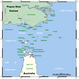 A map of the Torres Strait Islands showing "Ngurapai" just north of Cape York Peninsula | |
| Geography | |
| Location | Northern Australia |
| Archipelago | Torres Strait Islands |
| Adjacent to | Torres Strait |
| Area | 53 km2 (20 sq mi) |
| Administration | |
Australia | |
| State | Queensland |
| Additional information | |
| Official website | www |
Geography
The island is 53 km2 (20 sq mi) in area.
Horn Island is the site of Horn Island Airport, which also serves Thursday Island. Therefore, it is a gateway for travellers to the mainland and outer islands. The present-day population consists of islanders drawn from all islands of the Torres Strait, as well as non-islanders. Residents travel daily by ferry across the Ellis Channel to Thursday Island for work and school. Shire of Torres is the local government authority, providing the island community's municipal services.
History
Horn Island is known as Nœrupai (colloquially Nurupai) to the Kaurareg people and was given its English name by Matthew Flinders in 1802.[5]
The town of Wasaga was named on 1 April 1971 by the Queensland Place Names Board after Wasaga Billy, the first leader of the Horn Island community.[4]
After the 1871 massacre on Prince of Wales Island (Muralag), remnants of the people settled here for a short while, until the government relocated the Kaurareg to Hammond Island (Kœriri), where they remained until 1922. These islands (along with the other islands in the group) are the lands of the Kaurareg, each island – or parts thereof – owned by different clans.
The language of the Kaurareg is Kala Lagaw Ya, in the form of Kaiwalgau Ya (called Kauraraigau Ya [colloquial variant Kauraregau Ya] in the 19th century).
Gold was mined on Horn Island in the 1890s. In the early 20th century, a town flourished as a result of the pearling industry, but declined when non-islander residents were evacuated to southern Queensland during World War II. A major Allied airbase, known as Horn Island Aerodrome, was constructed on the island and this was attacked several times by Japanese planes.[6] The World War II airbase on Horn Island is described in Jack Woodward's historical biographies Under It Down Under and Singing for the Unsung.[7][8] Woodward was a World War II RAAF wireless operator stationed on Horn Island.[9]
Church influence was the London Missionary Society up until 1915 when the Anglican Church assumed responsibility.[clarification needed]
During World War II Horn Island Seaplane Base was built at Horn Island.[10]
In 1946, some of the Kaurareg (Nœrupai) people moved back from Kubin on Moa Island to Horn and settled here in present-day Wasaga Village at the western end of the island. In the late 1980s, gold was mined again and Horn saw the rapid expansion of its population and building activity, as land on neighbouring Thursday Island became scarce.
The Horn Island State School opened on 1 February 1993. It became a campus of Tagai State College on 1 January 2007.[11]
At the 2006 census, Horn Island had a population of 585 people.
At the 2011 census, Horn Island had a population of 539.[12]
Climate
Horn Island has a very warm tropical savanna climate (Af) with consistently hot temperatures all year round. The wet season lasts from December to April and features high humidity and frequent heavy downpours. Horn Island is occasionally affected by tropical cyclones; however it is too close to the Equator for them to be a significant threat. The dry season runs from May to November, and features lower humidity and little rainfall. Horn Island has never recorded a minimum temperature below 15 °C (59 °F) or a maximum temperature below 25 °C (77 °F).[13]
| Month | Jan | Feb | Mar | Apr | May | Jun | Jul | Aug | Sep | Oct | Nov | Dec | Year |
|---|---|---|---|---|---|---|---|---|---|---|---|---|---|
| Record high °C (°F) | 36.7 (98.1) |
35.4 (95.7) |
34.8 (94.6) |
33.9 (93.0) |
32.0 (89.6) |
32.4 (90.3) |
30.9 (87.6) |
31.7 (89.1) |
35.8 (96.4) |
35.2 (95.4) |
35.0 (95.0) |
37.9 (100.2) |
37.9 (100.2) |
| Average high °C (°F) | 30.9 (87.6) |
30.5 (86.9) |
30.4 (86.7) |
30.4 (86.7) |
29.9 (85.8) |
29.3 (84.7) |
28.8 (83.8) |
29.0 (84.2) |
30.1 (86.2) |
31.0 (87.8) |
31.9 (89.4) |
31.8 (89.2) |
30.3 (86.5) |
| Average low °C (°F) | 25.1 (77.2) |
25.0 (77.0) |
25.0 (77.0) |
25.2 (77.4) |
24.7 (76.5) |
23.9 (75.0) |
23.1 (73.6) |
22.9 (73.2) |
23.8 (74.8) |
24.8 (76.6) |
25.7 (78.3) |
25.7 (78.3) |
24.6 (76.3) |
| Record low °C (°F) | 22.4 (72.3) |
21.1 (70.0) |
22.2 (72.0) |
21.1 (70.0) |
17.7 (63.9) |
18.3 (64.9) |
16.0 (60.8) |
15.3 (59.5) |
16.1 (61.0) |
18.4 (65.1) |
19.9 (67.8) |
20.3 (68.5) |
15.3 (59.5) |
| Average precipitation mm (inches) | 387.5 (15.26) |
467.0 (18.39) |
358.2 (14.10) |
228.0 (8.98) |
72.5 (2.85) |
14.7 (0.58) |
8.3 (0.33) |
5.5 (0.22) |
6.3 (0.25) |
16.9 (0.67) |
49.1 (1.93) |
191.5 (7.54) |
1,809 (71.22) |
| Average precipitation days (≥ 0.2 mm) | 21.9 | 21.4 | 20.2 | 15.7 | 10.1 | 9.7 | 8.2 | 5.2 | 3.2 | 4.7 | 5.6 | 13.6 | 139.5 |
| Source: Bureau of Meteorology[13] | |||||||||||||
Education
Tagai State College is a government primary and secondary (early childhood - year 12) school for boys and girls that operates 17 campuses throughout the Torres Strait. On Horn Island, it has a primary (early childhood - year 6) campus at Nawie Street (10.5932°S 142.2512°E).[14][15]
There is no secondary school on Horn Island; the nearest is on neighbouring Thursday Island.[16]
Holy Family Catholic Church is in Outie Street. It is within the Thursday Island Parish of the Roman Catholic Diocese of Cairns.[17]
See also
References
- Australian Bureau of Statistics (27 June 2017). "Horn (SSC)". 2016 Census QuickStats. Retrieved 20 October 2018.
- "Horn Island – island in the Shire of Torres (entry 16142)". Queensland Place Names. Queensland Government. Retrieved 2 November 2019.
- "Horn – locality in Shire of Torres (entry 41960)". Queensland Place Names. Queensland Government. Retrieved 11 June 2019.
- "Wasaga – town in Shire of Torres (entry 36648)". Queensland Place Names. Queensland Government. Retrieved 11 June 2019.
- "Horn Island (Ngarupai)". Queensland Government. 4 February 2015. Retrieved 19 January 2020.
- Dunn, Peter. "JAPANESE BOMBING RAID ON HORN ISLAND 14 MARCH 1942". www.ozatwar.com. Retrieved 15 January 2013.
- Woodward, Jack (Jack J.) (1996), Under it down under : surviving in slit trenches, Jack Woodward, ISBN 978-0-646-27591-8
- Woodward, Jack (Jack J.) (2000), Singing for the unsung : WW2 New Guinea, J. Woodward], ISBN 978-0-9578278-0-6
- Dunn, Peter. "16 July 1942 - Crash of a B-17E Flying Fortress in the sea off Horn Island". Australia @ War. Archived from the original on 2 November 2019. Retrieved 2 November 2019.
- US Navy, Bases of World War II
- "Opening and closing dates of Queensland Schools". Queensland Government. Retrieved 18 April 2019.
- Australian Bureau of Statistics (31 October 2012). "Horn Island (L) (Urban Centre/Locality)". 2011 Census QuickStats. Retrieved 18 December 2016.
- "Climate Statistics for Horn Island". Climate statistics for Australian locations. Bureau of Meteorology. Retrieved 19 May 2013.
- "State and non-state school details". Queensland Government. 9 July 2018. Archived from the original on 21 November 2018. Retrieved 21 November 2018.
- "Tagai State College - Horn Island Campus". Archived from the original on 30 August 2012. Retrieved 21 November 2018.
- "Queensland Globe". State of Queensland. Retrieved 2 November 2019.
- "Thursday Island Parish". Roman Catholic Diocese of Cairns. Archived from the original on 18 November 2020. Retrieved 18 November 2020.
External links
 Media from Commons
 Travel information from Wikivoyage
- "Town map of Wasaga". Queensland Government. 1977.
List of Torres Strait topics | |||||||||||||||||||
|---|---|---|---|---|---|---|---|---|---|---|---|---|---|---|---|---|---|---|---|
| Torres Strait Islands, islets, and cays |
| ||||||||||||||||||
| People, culture, communities and languages |
| ||||||||||||||||||
| Governance and legal matters |
| ||||||||||||||||||
| Buildings and structures | |||||||||||||||||||
| Other |
| ||||||||||||||||||
На других языках
[de] Horn Island (Torres Strait)
Horn Island, auch Nguruapai oder Nurupai genannt, liegt im Archipel der Torres-Strait-Inseln, einer Inselgruppe in der Meerenge zwischen Australien und Papua-Neuguinea. Das acht Kilometern von der Hauptinsel Thursday Island entfernt gelegene Eiland hat eine Fläche von etwa 53 Quadratkilometern und wird von etwa 600 Menschen bewohnt. Der Verwaltungsgliederung nach gehört die Insel zu den Inner Islands, einer Inselregion im Verwaltungsbezirk Torres Shire von Queensland.- [en] Horn Island, Queensland
[fr] Île Horn (Australie)
L'île Horn ((en) Horn Island ; en Kaurareg : Narupai [Nœrupai/Nurupai]) est une île du détroit de Torrès, dans le Nord du Queensland, située entre l'Australie et la Papouasie-Nouvelle-Guinée.[it] Horn Island
Horn Island (in lingua locale: Ngarupai, Ngurupai, Nurupai o Narupai) è una delle Isole dello Stretto di Torres dell'Australia. Si trova a nord della penisola di Capo York. Appartiene alla contea di Torres[4]. A nord dell'isola c'è un aeroporto[5] e sulla costa nord-ovest, di fronte a Thursday Island, si trova il villaggio di Wasaga.Другой контент может иметь иную лицензию. Перед использованием материалов сайта WikiSort.org внимательно изучите правила лицензирования конкретных элементов наполнения сайта.
WikiSort.org - проект по пересортировке и дополнению контента Википедии