geo.wikisort.org - Island
Turtle Head Island is an island of the Torres Strait Islands archipelago, located in the Great Barrier Reef Marine Park, east of Cape York Peninsula, in Queensland, Australia.
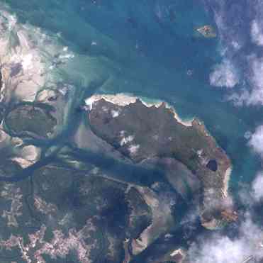 Turtle Head Island (centre) with Turtle Island (top right) and Trochus Island (middle left). | |
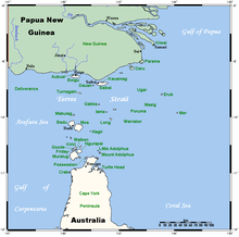 A map of the Torres Strait Islands showing Turtle Head Island in the south eastern waters of Torres Strait, east of the Cape York Peninsula | |
| Geography | |
|---|---|
| Location | Great Barrier Reef Marine Park, Northern Australia |
| Coordinates | 10°55′48″S 142°40′48″E |
| Archipelago | Torres Strait Islands |
| Adjacent to | Torres Strait |
| Administration | |
Australia | |
| State | Queensland |
| Local government area | Shire of Torres |
| Demographics | |
| Ethnic groups | Torres Strait Islanders |
The island is located in Newcastle Bay at the mouth of Escape River and Middle River, not far from Jackey Jackey Creek and adjacent to the Apudthama National Park. The island lies approximately 30 km (19 mi) southeast of Bamaga.

See also
References
This article does not cite any sources. (December 2009) |
List of Torres Strait topics | |||||||||||||||||||
|---|---|---|---|---|---|---|---|---|---|---|---|---|---|---|---|---|---|---|---|
| Torres Strait Islands, islets, and cays |
| ||||||||||||||||||
| People, culture, communities and languages |
| ||||||||||||||||||
| Governance and legal matters |
| ||||||||||||||||||
| Buildings and structures | |||||||||||||||||||
| Other |
| ||||||||||||||||||
This Queensland protected areas related article is a stub. You can help Wikipedia by expanding it. |
На других языках
[de] Turtle Head Island
Turtle Head Island ist eine australische Insel im äußersten Süden des Archipels der Torres-Strait-Inseln. Sie liegt unmittelbar vor der Ostküste der Kap-York-Halbinsel in der Newcastle Bay in Höhe der Mündung des Escape River. 1,3 km westlich von Turtle Head liegen Trochus Island, 3,5 km nördlich die Eilande Turtle- und Brewis Island.- [en] Turtle Head Island
Текст в блоке "Читать" взят с сайта "Википедия" и доступен по лицензии Creative Commons Attribution-ShareAlike; в отдельных случаях могут действовать дополнительные условия.
Другой контент может иметь иную лицензию. Перед использованием материалов сайта WikiSort.org внимательно изучите правила лицензирования конкретных элементов наполнения сайта.
Другой контент может иметь иную лицензию. Перед использованием материалов сайта WikiSort.org внимательно изучите правила лицензирования конкретных элементов наполнения сайта.
2019-2026
WikiSort.org - проект по пересортировке и дополнению контента Википедии
WikiSort.org - проект по пересортировке и дополнению контента Википедии