geo.wikisort.org - Island
Coconut Island, Poruma Island, or Puruma in the local language, is an island in the Great North East Channel near Cumberland Passage, Torres Strait, Queensland, Australia. One of the Torres Strait Islands, Coconut Island is 130 kilometres (81 mi) northeast of Thursday Island. Administratively, Coconut Island is a town and Poruma Island is the locality within the Shire of Torres.[2][3][4][5][6]
Native name: Poruma | |
|---|---|
 Satellite image of Coconut Island | |
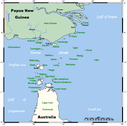 A map of the Torres Strait Islands with the Coconut Island labelled as Poruma | |
| Geography | |
| Location | Northern Australia |
| Adjacent bodies of water | Great North East Channel, Torres Strait |
| Administration | |
Australia | |
| State | Queensland |
| Coconut Island / Pormula Island Queensland | |
|---|---|
 Coconut Island / Pormula Island | |
| Coordinates | 10.0502°S 143.0694°E |
| Population | 167 (2016 census)[1] |
| Postcode(s) | 4875 |
| LGA(s) | Torres Strait Island Region |
| State electorate(s) | Cook |
| Federal division(s) | Leichhardt |
The ancestors of Coconut Island built their houses out of grass, coconut leaves and trees that floated down from the Fly River jungles of Papua New Guinea.
The islands have sea turtle hatcheries, bird life, giant clam ground, huge palms, World War II relics and massive sand flats.
Language
The language of Poruma (locally known as Puruma) is the Kulkalgau Ya dialect of Kalau Lagau Ya.
Poruma, also known as Coconut Island, is situated in the central island group of the Torres Strait. It is a narrow coral island approximately 1.4 km long and 400m wide, bounded by shallow, fringing coral reefs. The Torres Strait Islander people of Poruma are of Melanesian origin and lived in village communities following traditional patterns of hunting, fishing and trade for many thousands of years before contact was made with the first European visitors to the region.[7][8]
The Traditional Owners of Poruma are the Billy and Fauid (Fy-Hood) families.[9]
History
In the 1860s, beche-de-mer (sea cucumber) and pearling boats began working the reefs of Torres Strait. An unnamed Frenchman and an operator named Colin Thomson are believed to have harvested the reefs surrounding Poruma in the 1860s.
Another operator named Captain Walton began employing men from Poruma to work as divers and crew on his vessels in the early 1870s.[10][11] An Englishman named George Pearson operated a pearling station on Poruma in the 1870s[12][13] and a semi-permanent floating beche-de-mer station was established near the island around 1872.
In 1872, the Queensland Government sought to extend its jurisdiction and requested the support of the British Government.[14] Letters Patent were issued by the British Government in 1872 creating a new boundary for the colony,[15] which encompassed all islands within a 60 nautical mile radius of the coast of Queensland. This boundary was further extended to 96 km by the Queensland Coast Islands Act 1879 (Qld) [16] and included the islands of Boigu, Erub, Mer and Saibai, which lay beyond the previous 60 nautical mile limit. The new legislation enabled the Queensland Government to control and regulate bases for the beche-de-mer and pearling industries which previously had operated outside its jurisdiction.[17]
Torres Strait Islanders refer to the arrival of London Missionary Society (LMS) missionaries in July 1871 as ‘the Coming of the Light.’ Around 1900, the LMS missionary Rev. Walker established a philanthropic business scheme named Papuan Industries Limited (PIL). PIL encouraged Islander communities to co-operatively rent or purchase their own pearl luggers or ‘company boats.’ The ‘company boats’, were used to harvest pearl shells and beche-de-mer, which was sold and distributed by PIL. The people of Poruma purchased their first company boats around 1905. Company boats provided Islanders with income and a sense of community pride and also improved transport and communication between the islands.[18][19][20]
In November 1912, 800 acres of land on Poruma were officially gazetted as an Aboriginal reserve by the Queensland Government. Many other Torres Strait Islands were gazetted as Aboriginal reserves at the same time.[21] A government report from 1912 mentioned that Poruma was used as a rendezvous point and anchorage for fishing and pearl boats and suggested that the Islander population be removed to Yorke Island, to allow the children of the island to attend the new school on Yorke Island.[22] Reports from 1913 indicate that while some Islander families left Poruma and moved to Sue and Yorke Islands, many refused to leave the island.[23]
By 1918, a Protector of Aboriginals had been appointed to Thursday Island and, during the 1920s and 1930s, racial legislation was strictly applied to Torres Strait Islanders, enabling the government to remove Islanders to reserves and mission across Queensland. A world-wide influenza epidemic reached the Torres Strait in 1920, resulting in 96 deaths in the region. The Queensland Government provided the Islands of Coconut, Yorke and Yam with food relief to help them recover from the outbreak.[24][25] In March 1923, the islands of Coconut and Yorke were hit by a ‘violent hurricane’ which destroyed local crops and gardens.[26]
In 1936, around 70% of the Torres Strait Islander workforce went on strike in the first organised challenge against government authority made by Torres Strait Islanders. The nine-month strike was an expression of Islanders’ anger and resentment at increasing government control of their livelihoods. The strike was a protest against government interference in wages, trade and commerce and also called for the lifting of evening curfews, the removal of the permit system for inter-island travel and the recognition of Islanders’ right to recruit their own boat crews.[27][28]
The strike produced a number of significant reforms and innovations. Unpopular local Protector J.D McLean was removed and replaced by Cornelius O’Leary. O’Leary established a system of regular consultations with elected Islander council representatives. The new island councils were given a degree of autonomy, including control over local police and courts.[29]
On 23 August 1937, O’Leary convened the first Inter Islander Councillors Conference at Yorke Island. Representatives from 14 Torres Strait communities attended. Mimia and Abiu Fauid represented Poruma at the conference. After lengthy discussions, unpopular bylaws (including the evening curfews) were cancelled, and a new code of local representation was agreed upon.[30] In 1939, the Queensland Government passed the Torres Strait Islander Act 1939, which incorporated many of the recommendations discussed at the conference. A key section of the new act officially recognised Torres Strait Islanders as a separate people from Aboriginal Australians.[31]
During World War II, the Australian government recruited Torres Strait Islander men to serve in the armed forces. Enlisted men from Coconut and other island communities formed the Torres Strait Light Infantry. While the Torres Strait Light Infantry were respected as soldiers, they only received one third of the pay given to white Australian servicemen. On 31 December 1943, members of the Torres Strait Light Infantry went on strike, calling for equal pay and equal rights.[32] The Australian Government agreed to increase their pay to two thirds the level received by white servicemen. Full back pay was offered in compensation to the Torres Strait servicemen by the Australian Government in the 1980s.[33][32] After World War II, the pearling industry declined across Torres Strait and Islanders were permitted to work and settle on the Australian mainland.
In December 1978, a treaty was signed by the Australian and Papua New Guinea governments that described the boundaries between the 2 countries and the use of the sea area by both parties.[34] The Torres Strait Treaty, which commenced operation in February 1985, contains special provision for free movement (without passports or visas) between both countries.[35] Free movement between communities applies to traditional activities such as fishing, trading and family gatherings which occur in a specifically created Protected Zone and nearby areas.[36]
Coconut Island State School opened on 29 January 1985. On 23 March 2005 it was renamed Poruma State School. On 1 January 2007 the school became a campus of Tagai State College and was renamed Tagai State College - Poruma Campus. [37]
On 30 March 1985, the Poruma community elected 3 councillors to constitute an autonomous Poruma Council established under the Community Services (Torres Strait) Act 1984. The Act conferred local government type powers and responsibilities upon Torres Strait Islander councils. The council area, previously an Aboriginal reserve held by the Queensland Government, was transferred on 21 October 1985 to the trusteeship of the council under a Deed of Grant in Trust.[38] On 24 April 2002, the council’s name was changed from Poruma Council to Poruma Island Council. In 2007, the Local Government Reform Commission recommended that the 15 Torres Strait Island councils be abolished and the Torres Strait Island Regional Council (TSIRC) be established in their place. In elections conducted under the Local Government Act 1993 on 15 March 2008, members of the 15 communities comprising the Torres Strait Island Regional Council local government area each voted for a local councillor and a mayor to constitute a council of 15 councillors plus a mayor.
In the 2011 census, Poruma Island had a population of 149 people.[39]
In the 2016 census, Poruma Island had a population of 167 people.[1]
Education
Tagai State College - Poruma Campus is a primary (Early Childhood-6) campus at Olandi Street (10.0503°S 143.0641°E) of Tagai State College (headquartered at Thursday Island) .[40][41]
Amenities
The Torres Strait Island Regional Council operates the Poruma (Ngalpun Ngulaygaw Lag) Library on Main Street.[42]
See also
References
- Australian Bureau of Statistics (27 June 2017). "Poruma Island (SSC)". 2016 Census QuickStats. Retrieved 20 October 2018.
- "Coconut Island – island (entry 7650)". Queensland Place Names. Queensland Government. Retrieved 2 February 2015.
- "Coconut Island – town (entry 7655)". Queensland Place Names. Queensland Government. Retrieved 9 March 2017.
- "Poruma Island – locality (entry 46713)". Queensland Place Names. Queensland Government. Retrieved 9 March 2017.
- Torres Strait: the region and its people Archived 1 March 2015 at the Wayback Machine Torres Strait
- Poruma (Coconut Island) Archived 7 January 2015 at the Wayback Machine Torres Strait Island Regional Council
- R E Johannes & J W MacFarlane, Traditional Fishing in the Torres Strait Islands(CSIRO; 1991) 113-114
- M Fuary, In So Many Words: An Ethnography of Life and Identity on Yam Island, Torres Strait (PhD Thesis, James Cook University, Townsville; 1991) 68-71.
- Patrick Thaiday & Ors on behalf of the Warraber, Poruma and Iama Peoples v State of Queensland & Ors [2005] FCA 1116.
- M FuaryAbove n1, 138
- S Mullins, Torres Strait, A History of Colonial Occupation and Culture Contact 1864-1897 (Central Queensland University Press, Rockhampton; 1994) 74.
- S Mullins, Above n3, 78, 163
- Anna Shnukal Genealogies – Pearson Family.
- S B Kaye, Jurisdictional Patchwork: Law of the Sea and Native Title Issues in the Torres Strait (2001) 2, Melbourne Journal of International Law.
- Queensland, Queensland Statutes (1963) vol.2, 712.
- See also Colonial Boundaries Act 1895 (Imp); Wacando v Commonwealth(1981) 148 CLR 1.
- S Mullins, Above n3, 139-161
- R Ganter, The Pearl Shellers of Torres Straits (Melbourne University Press, Melbourne; 1994) 68-75
- Queensland, Annual Report of the Chief Protector of Aboriginals for 1905 (1906) 29
- N Sharp, Stars of Tagai, The Torres Strait Islanders (Aboriginal Studies Press, Canberra; 1993)158-161.
- Queensland Government Gazette, vol.99, no.138 (1912) 1330.
- Queensland, Annual Report of the Chief Protector of Aboriginals for 1912(1913) 6, 21.
- Queensland, Annual Report of the Chief Protector of Aboriginals for 1913(1914) 13; Queensland State Archives, A/58755, 1914/3284, extracts from the Annual Report of the Thursday Island Protector of Aboriginals for 1912(1913) and the Annual Report of the Thursday Island Protector of Aboriginals for 1913 (1914)
- Queensland, Annual Report of the Chief Protector of Aboriginals for 1920(1921) 7
- M Fuary, In So Many Words, 148.
- Queensland, Annual Report of the Chief Protector of Aboriginals for 1923(1924) 6.
- N Sharp, Above n9 181-186, 278
- J Beckett, Torres Strait Islanders, Custom and Colonialism (Cambridge University Press, Cambridge; 1987) 54.
- J Beckett, Torres Strait Islanders, 54-55.
- N Sharp, Above n9, 210-214; Queensland, Annual Report of the Department of Native Affairs for 1937 (1938) 13; Queensland State Archives, A/3941 Minutes of Torres Strait Councillors Conference held at Yorke Island 23–25 August 1937.
- Sections 3 (a) – (c) of the Torres Strait Islander Act (Qld) 1939. See also: Queensland, Annual Report of the Department of Native Affairs for 1939(1940) 1; N Sharp, Stars of Tagai, 214-216.
- Seekee, Vanessa. ""One ilan man": the Torres Strait Light Infantry". Archived from the original on 19 March 2020. Retrieved 11 April 2020.
- J. Beckett, Above n15, p.64-65
- For further information see: Australia, Department of Foreign Affairs and Trade, www.dfat.gov.au/geo/torres_strait/index.html#brief; Sharp, 226-227.
- Under Art. 11.
- See also Art 12.
- Queensland Family History Society (2010), Queensland schools past and present (Version 1.01 ed.), Queensland Family History Society, ISBN 978-1-921171-26-0
- Queensland, Annual Report of the Department of Community Services for 1986(1987) 3; Queensland, Annual Report of the Department of Community Services for 1987 (1988) 29.
- Australian Bureau of Statistics (31 October 2012). "Poruma Island (SSC)". 2011 Census QuickStats. Retrieved 2 February 2015.
- "State and non-state school details". Queensland Government. 9 July 2018. Archived from the original on 21 November 2018. Retrieved 21 November 2018.
- "Tagai State College - Poruma Campus". Archived from the original on 30 August 2012. Retrieved 21 November 2018.
- "Poruma (Ngalpun Ngulaygaw Lag) Library". Public Libraries Connect. Archived from the original on 31 January 2018. Retrieved 31 January 2018.
Attribution
This Wikipedia article contains material from Aboriginal and Torres Strait Islander community histories:Poruma (Coconut Island). Published by The State of Queensland under CC-BY-4.0, accessed on 3 July 2017.
Further reading
- Hegarty, Siobhan (6 February 2020). "'To everybody else this place is sinking. It will never sink'". ABC News (Radio National). Australian Broadcasting Corporation.
External links
List of Torres Strait topics | |||||||||||||||||||
|---|---|---|---|---|---|---|---|---|---|---|---|---|---|---|---|---|---|---|---|
| Torres Strait Islands, islets, and cays |
| ||||||||||||||||||
| People, culture, communities and languages |
| ||||||||||||||||||
| Governance and legal matters |
| ||||||||||||||||||
| Buildings and structures | |||||||||||||||||||
| Other |
| ||||||||||||||||||
| Authority control |
|
|---|
Другой контент может иметь иную лицензию. Перед использованием материалов сайта WikiSort.org внимательно изучите правила лицензирования конкретных элементов наполнения сайта.
WikiSort.org - проект по пересортировке и дополнению контента Википедии