geo.wikisort.org - Island
Boigu Island (also known as Malu Kiyay or Malu Kiwai) is the most northerly inhabited island of Queensland and of Australia.[2] It is part of the Top Western group of the Torres Strait Islands, which lie in the Torres Strait separating Cape York Peninsula from the island of New Guinea. The mainland of Papua New Guinea is only 6 kilometres (3.7 mi) away from Boigu. Boigu has an area of 89.6 square kilometres (34.6 sq mi). Boigu Island is the name of the locality on the island within the Torres Strait Island Region.[3] Boigu is predominantly inhabited by indigenous Torres Strait Islanders. In the 2021 census, the population of the island was 199, of whom 189 identified as Indigenous Australians.[1]
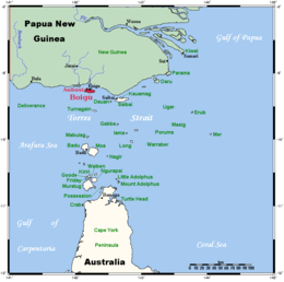 Boigu within the Torres Strait Islands | |
 Boigu Island Boigu Island (Queensland, Australia) | |
| Geography | |
|---|---|
| Location | Torres Strait |
| Coordinates | 9.2594°S 142.2127°E |
| Archipelago | Torres Strait Islands |
| Area | 89.6 km2 (34.6 sq mi) |
| Length | 18.12 km (11.259 mi) |
| Width | 5.05 km (3.138 mi) |
| Highest elevation | 18 m (59 ft) |
| Highest point | unnamed |
| Administration | |
Australia | |
| State | Queensland |
| LGA | Torres Strait Island Region |
| Island Region | Top Western |
| Largest settlement | Boigu |
| Demographics | |
| Population | 199 (2021) |
| Pop. density | 3.0/km2 (7.8/sq mi) |
| Ethnic groups | Torres Strait Islanders |
| Boigu Island Queensland | |||||||||||||||
|---|---|---|---|---|---|---|---|---|---|---|---|---|---|---|---|
 Boigu Island | |||||||||||||||
| Coordinates | 9.2594°S 142.2127°E | ||||||||||||||
| Population | 199 (2021 census)[1] | ||||||||||||||
| • Density | 3.002/km2 (7.774/sq mi) | ||||||||||||||
| Area | 66.3 km2 (25.6 sq mi) | ||||||||||||||
| Time zone | AEST (UTC+10:00) | ||||||||||||||
| LGA(s) | Torres Strait Island Region | ||||||||||||||
| State electorate(s) | Cook | ||||||||||||||
| Federal division(s) | Leichhardt | ||||||||||||||
| |||||||||||||||
It is the largest and only inhabited island of the Talbot Islands group (9.2591°S 142.2064°E).[4]
Language and affiliations
The language of Boigu is that of the Western and Central Islands of the Torres Strait. The specific dialect is Kalau Kawau Ya, also spoken on the islands of Dauan and Saibai. The people of the three islands consider themselves as one people.
Kala Kawaw Ya (also known as Kalaw Kawaw, KKY) is one of the languages of the Torres Strait. Kala Kawaw Ya is the traditional language owned by the Top Western islands of the Torres Strait Island Region.[5]
Geography
Boigu Island is approximately 18 kilometres (11 mi) long, and low-lying. It was formed by the accumulation of alluvial sediments deposited by the discharge of nearby New Guinean rivers into the Strait. These sediments built up over time on an old coral platform which rises from the shallow continental shelf, eventually creating the island.
The village of Boigu at the northern end of the island (9.2324°S 142.2186°E).[6] It is the northernmost settlement of Australia, but the northernmost land is the uninhabited Bramble Cay, 173 kilometres (107 mi) to the east.[7]
Most of the island is subject to extensive periodic flooding, and as a result the community township has been built on the highest ground.[citation needed]
There are a number of smaller islands nearby, including:
- Aubussi Island, also known as Awbuz (9.2342°S 142.1700°E)[8][9]
- Moegina Kawa (9.2285°S 142.1472°E)[9]
- Sapural Kawa (9.2240°S 142.1487°E)[9]
- Aymermud (9.2319°S 142.1571°E)[9]
- Moimi Island, also known as Moeyim (9.2280°S 142.2419°E)[9][10]
Boigu Island Airport is on the south-western edge of the village (9.2327°S 142.2181°E).[11]
History
Boigu was visited by South Sea Islander missionaries of the London Missionary Society, some time after the establishment of a mission on nearby Saibai Island in 1871.[citation needed]
From the 1870s to around 1910, the Boigu, Dauan and Saibai people, along with the neighbouring Papuan peoples, were being harassed by thugeral "warriors" from the Marind-anim, fierce headhunters from what is now southeast West Papua. In literature dealing with the period, these people are generally termed 'Tuger' or 'Tugeri'. Sir William MacGregor, the Lieutenant-Governor of British New Guinea, noted in 1886 that the population was nearly extinct as a result of these raids. What he did not realise was that at the time the bulk of the population were staying with family on Saibai and Dauan for mutual protection.[citation needed]
According to 2004 Torres Strait Regional Authority (TSRA) figures, its resident population was approximately 340.[citation needed]
Malu Kiwai State School opened on 29 January 1985. In 2007, it was one of 17 schools in the Torres Strait Islands that amalgamated, becoming the Malu Kiwai Campus of Tagai State College (which has its main campus on Thursday Island).[12][13]
In the 2016 census, there were 271 people living on the island, of whom 231 identified as Indigenous Australians (107 male, 124 female).[14]
In the 2021 census, there were 199 people living on the island, of whom 189 identified as Indigenous Australians (84 male, 104 female).[1]
Ecology
The island is considered part of the New Guinea mangroves ecoregion, a subset of the Australasian realm.[citation needed]
The interior of the island is sparsely vegetated, and mainly swampland. The coast is fringed by mangroves, which act to protect against the island's sand and mud from sea erosion.[citation needed]
It is likely the mangrove regions harbour healthy populations of saltwater crocodile.[citation needed]
The waters surrounding the island are an important habitat for dugongs, a species of sea mammal listed as vulnerable by the IUCN.[citation needed]
Education

The Malu Kiwai Campus of the Tagai State College is a primary (Early Childhood-6) campus of Tagai State College at School Road (9.2310°S 142.2193°E).[15][16][17]
There is no secondary school on the island. The secondary school campus of Tagai State College is on Thursday Island.[18]
Amenities
The Torres Strait Island Regional Council operates an Indigenous Knowledge Centre (library) at 66 Chamber Street (9.2304°S 142.2208°E).[19][20]
Boigu Island Primary Health Care Centre is operated by Queensland Health on Chamber Street (9.2307°S 142.2209°E).[21][22]
Boigu Island Sewage Treatment Plant is on the western edge of the village on the Esplanade (9.2317°S 142.2166°E).[21]
See also
References
- Australian Bureau of Statistics (28 June 2022). "Boigu Island (SAL)". 2021 Census QuickStats. Retrieved 8 August 2022.
- "Boigu Island – island in the Torres Strait Island Region (entry 3484)". Queensland Place Names. Queensland Government. Retrieved 7 August 2022.
- "Boigu Island – locality in the Torres Strait Island Region (entry 46701)". Queensland Place Names. Queensland Government. Retrieved 7 August 2022.
- "Island groups - Queensland". Queensland Open Data. Queensland Government. 12 November 2020. Archived from the original on 25 November 2020. Retrieved 25 November 2020.
-
 This Wikipedia article incorporates CC-BY-4.0 licensed text from: "Indigenous languages map of Queensland". State Library of Queensland. State Library of Queensland. Retrieved 5 February 2020.
- "Boigu – population centre in Torres Strait Island Regional (entry 3483)". Queensland Place Names. Queensland Government. Retrieved 7 March 2022.
- "Bramble Cay – island in the Shire of Torres (entry 4280)". Queensland Place Names. Queensland Government. Retrieved 7 August 2022.
- "Aubussi Island – island (entry 993)". Queensland Place Names. Queensland Government. Retrieved 25 November 2020.
- "Marine islands - Queensland". Queensland Open Data. Queensland Government. 12 November 2020. Archived from the original on 25 November 2020. Retrieved 25 November 2020.
- "Moimi Island – island (entry 22437)". Queensland Place Names. Queensland Government. Retrieved 25 November 2020.
- "Airports - Queensland". Queensland Open Data. Queensland Government. 22 October 2020. Archived from the original on 15 November 2020. Retrieved 3 November 2020.
- Queensland Family History Society (2010), Queensland schools past and present (Version 1.01 ed.), Queensland Family History Society, ISBN 978-1-921171-26-0
- "Principal's welcome". Tagai State College. 19 May 2020. Archived from the original on 21 March 2022. Retrieved 7 August 2022.
- Australian Bureau of Statistics (27 June 2017). "Boigu Island". 2016 Census QuickStats. Retrieved 7 August 2022.
- "State and non-state school details". Queensland Government. 9 July 2018. Archived from the original on 21 November 2018. Retrieved 21 November 2018.
- "Boigu Island - Malu Kiyay Ngurpay Lag". Tagai State College. 21 February 2019. Archived from the original on 3 March 2022. Retrieved 7 August 2022.
- "Tagai State College". Tagai State College. 19 May 2020. Archived from the original on 30 August 2012. Retrieved 7 August 2022.
- "Queensland Globe". State of Queensland. Retrieved 7 August 2022.
- "Boigu". Public Libraries Connect. State Library of Queensland. 28 August 2017. Archived from the original on 31 January 2018. Retrieved 31 January 2018.
- "Boigu: An IKC with a point of difference | State Library Of Queensland". www.slq.qld.gov.au. 22 June 2022. Archived from the original on 22 June 2022. Retrieved 7 August 2022.
- "Landmark Areas - Queensland". Queensland Open Data. Queensland Government. 18 November 2020. Archived from the original on 21 November 2020. Retrieved 21 October 2020.
- "Boigu Island Primary Health Care Centre Profile". Queensland Health. Archived from the original on 29 March 2022. Retrieved 7 August 2022.
External links
- Community History Boigu Community History[permanent dead link]
List of Torres Strait topics | |||||||||||||||||||
|---|---|---|---|---|---|---|---|---|---|---|---|---|---|---|---|---|---|---|---|
| Torres Strait Islands, islets, and cays |
| ||||||||||||||||||
| People, culture, communities and languages |
| ||||||||||||||||||
| Governance and legal matters |
| ||||||||||||||||||
| Buildings and structures | |||||||||||||||||||
| Other |
| ||||||||||||||||||
На других языках
[de] Boigu
Boigu, engl.: Boigu Island, ist die größte Insel der Talbot-Inseln und die fünftgrößte im Archipel der Torres-Strait-Inseln, die zum australischen Bundesstaat Queensland gehören.- [en] Boigu Island (Queensland)
[fr] Île Boigu
L'île Boigu (Boigu Island) est l'île habitée la plus septentrionale du Queensland et de l'Australie. Elle fait partie du groupe d'îles à l'extrême ouest du détroit de Torrès séparant la péninsule du cap York de la Nouvelle-Guinée. La partie continentale de la Papouasie-Nouvelle-Guinée se trouve à seulement 6 km de Boigu. Boigu a une superficie de 89,6 km2.[it] Boigu Island
Boigu Island è un'isola dell'arcipelago delle Torres Strait Islands situata nello stretto di Torres. Si trova a soli 6 km dalla costa della Nuova Guinea ed è l'isola più a nord del Queensland e dell'Australia. Appartiene alla regione di Torres Strait Island. La popolazione dell'isola, nel censimento del 2016, era di 271 abitanti[2].[ru] Боигу
Боигу (англ. Boigu Island) — остров в северной части группы островов Торресова пролива (Квинсленд, Австралия).Другой контент может иметь иную лицензию. Перед использованием материалов сайта WikiSort.org внимательно изучите правила лицензирования конкретных элементов наполнения сайта.
WikiSort.org - проект по пересортировке и дополнению контента Википедии