geo.wikisort.org - Island
Turnagain, also called Buru Island, is an island of the Western Islands region of the Torres Strait Islands archipelago, located in the northern section of Torres Strait, Queensland, Australia. Turnagain is located within the Torres Strait Island Region Local government area.
Buru Island | |
|---|---|
 A Landsat image of Turnagain Island | |
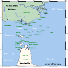 A map of the Torres Strait Islands showing Turnagain in the northern central waters of Torres Strait | |
| Geography | |
| Location | Northern Australia |
| Coordinates | 9°34′01″S 142°16′59″E |
| Archipelago | Torres Strait Islands |
| Adjacent bodies of water | Torres Strait |
| Area | 11.98 km2 (4.63 sq mi) |
| Length | 7.5 km (4.66 mi) |
| Width | 2.2 km (1.37 mi) |
| Administration | |
Australia | |
| State | Queensland |
| Local government area | Torres Strait Island Region |
Geography
The island is located approximately 38 kilometres (24 mi) south of the Western Province of Papua New Guinea. Turnagain is 7.5 kilometres (4.7 mi) in length and up to 2.2 kilometres (1.4 mi) wide. Its area of 11.98 square kilometres (4.63 sq mi) is heavily wooded. It is uninhabited and is the shape of an elongated teardrop.
See also
References
This article needs additional citations for verification. (April 2015) |
External links
List of Torres Strait topics | |||||||||||||||||||
|---|---|---|---|---|---|---|---|---|---|---|---|---|---|---|---|---|---|---|---|
| Torres Strait Islands, islets, and cays |
| ||||||||||||||||||
| People, culture, communities and languages |
| ||||||||||||||||||
| Governance and legal matters |
| ||||||||||||||||||
| Buildings and structures | |||||||||||||||||||
| Other |
| ||||||||||||||||||
This Queensland location article is a stub. You can help Wikipedia by expanding it. |
На других языках
[de] Turnagain Island
Turnagain Island, auch Buru genannt, ist eine kleine unbewohnte Insel der Torres-Strait-Inseln. Sie liegt etwa 38 km südlich der Küste von Papua-Neuguinea und über 125 km nördlich der Kap-York-Halbinsel, gehört aber dennoch zum australischen Bundesstaat Queensland. Die nächstgelegenen Inseln sind Dauan (29 km nordöstlich) und Boigu (29 km nordwestlich), beide bewohnt.- [en] Turnagain Island (Queensland)
Текст в блоке "Читать" взят с сайта "Википедия" и доступен по лицензии Creative Commons Attribution-ShareAlike; в отдельных случаях могут действовать дополнительные условия.
Другой контент может иметь иную лицензию. Перед использованием материалов сайта WikiSort.org внимательно изучите правила лицензирования конкретных элементов наполнения сайта.
Другой контент может иметь иную лицензию. Перед использованием материалов сайта WikiSort.org внимательно изучите правила лицензирования конкретных элементов наполнения сайта.
2019-2025
WikiSort.org - проект по пересортировке и дополнению контента Википедии
WikiSort.org - проект по пересортировке и дополнению контента Википедии