geo.wikisort.org - Island
Sanday (Scottish Gaelic: Sandaigh; Scots: Sandee) is one of the Small Isles, in the Scottish Inner Hebrides. It is a tidal island linked to its larger neighbour, Canna, via sandbanks at low tide, and also connected to the larger island by a bridge. Canna and Sanday form a single community, and are usually described as Canna.
| Scottish Gaelic name | Sandaigh |
|---|---|
| Scots name | Sandee[1] |
| Location | |
 Sanday Sanday shown within Lochaber | |
| OS grid reference | NG282043 |
| Coordinates | 57.05°N 6.49°W |
| Physical geography | |
| Island group | Small Isles |
| Area | 184 ha (0.71 sq mi) |
| Area rank | 114 [2] |
| Highest elevation | 59 m (194 ft) |
| Administration | |
| Sovereign state | United Kingdom |
| Country | Scotland |
| Council area | Highland |
| Demographics | |
| Population | 9[3] |
| Population rank | 69 [2] |
| Population density | 5 people/km2[3][4] |
| References | [4][5] |
Like its neighbour, Canna, the whole island is owned by the National Trust for Scotland (NTS), and is part of the Lochaber committee area of Highland Council.[6] Whereas Canna is run by the NTS as a single farm, parts of Sanday are used for crofting.
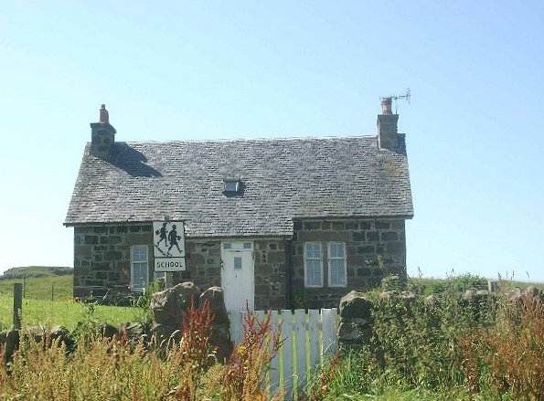
A small primary school on Sanday served the communities of both islands, although is currently closed.[7] A footbridge to the island was built in 1905 to allow pupils from Canna to reach the school regardless of the state of the tide. This bridge was destroyed by storms in 2005, and has been replaced by a road bridge which was completed in April 2006. This new bridge allows vehicular access at all tide levels between the two islands, although parts of the road on Sanday were still covered by water during high tides until the completion of a new road in 2018.[7]
From the mainland the island can be reached by the Caledonian MacBrayne ferry system from the port of Mallaig. Sanday includes rocks that are geologically part of the Paleocene and Eocene British Tertiary Volcanic Province, among some of the youngest rocks found in Scotland.[8]
The largest and most conspicuous building on Sanday is the deconsecrated Catholic church of St Edward, which stands alone on an elevated part of the island, away from the cottages which, together with the school, cluster around the bay facing Canna.
The church, which is also owned by the National Trust for Scotland, was restored and converted into a hostel and Study Centre by the Hebridean Trust. This project was undertaken at the invitation of the owners. The Centre is linked to the Archive of Gaelic language and culture that was created by the former owner of Canna and Sanday, the late John Lorne Campbell. It was successfully completed and opened in 2001 by the Princess Royal. Subsequently, there was water ingress, which caused damage to the interior. This challenge is in the hands of the National Trust for Scotland.
The island is home to a number of different types of wildlife, including puffins, great skua and Manx shearwater.[9]


See also
References
- "Map of Scotland in Scots - Guide and gazetteer" (PDF).
- Area and population ranks: there are c. 300 islands over 20 ha in extent and 93 permanently inhabited islands were listed in the 2011 census.
- National Records of Scotland (15 August 2013). "Appendix 2: Population and households on Scotland's Inhabited Islands" (PDF). Statistical Bulletin: 2011 Census: First Results on Population and Household Estimates for Scotland Release 1C (Part Two) (PDF) (Report). SG/2013/126. Retrieved 14 August 2020.
- Haswell-Smith, Hamish (2004). The Scottish Islands. Edinburgh: Canongate. ISBN 978-1-84195-454-7.
- Ordnance Survey: Landranger map sheet 39 Rùm, Eigg, Muck & Canna (Map). Ordnance Survey. 2007. ISBN 9780319229941.
- Patterson, A (June 2000). "Seabird Enhancement Programme on the Islands of Canna and Sanday". Case Studies -- Species Regeneration. National Trust for Scotland. Archived from the original on 9 May 2006. Retrieved 10 June 2006.
- "First road built on tiny island of Sanday". BBC Scotland. 11 June 2018. Retrieved 11 June 2018.
- "Tertiary Igneous (TER-IGN)". Geological Conservation Review GCR Database. Joint Nature Conservation Committee. Archived from the original on 28 September 2007. Retrieved 10 June 2006.
- Scotland, National Trust for (20 February 2019). "3 key projects". National Trust for Scotland. Retrieved 20 February 2019.
External links
На других языках
[de] Sanday (Hebriden)
Sanday (schottisch-gälisch Sandaigh) ist eine Gezeiteninsel im Westen der „Kleinen Inseln“, die Bestandteil der schottischen Inneren Hebriden in den Highlands sind. Sie ist 3 Kilometer lang. Die Insel gehört dem National Trust for Scotland.- [en] Sanday, Inner Hebrides
[fr] Sanday (Hébrides intérieures)
Sanday est une île faisant partie du groupe des Small Isles qui appartiennent à l'archipel des Hébrides intérieures en Écosse. Sanday est située dans la mer des Hébrides et fait partie du Council area des Highland. Elle appartient depuis 1981 au National Trust for Scotland.[ru] Сандей (Внутренние Гебриды)
Са́ндей (англ. Sanday, гэльск. Sandaigh) — приливный остров в составе островов Смолл-Айлс, Внутренние Гебридские острова, область Хайленд, Шотландия, Великобритания.Другой контент может иметь иную лицензию. Перед использованием материалов сайта WikiSort.org внимательно изучите правила лицензирования конкретных элементов наполнения сайта.
WikiSort.org - проект по пересортировке и дополнению контента Википедии