geo.wikisort.org - Island
The island of Vatersay (/ˈvætərseɪ/; Scottish Gaelic: Bhatarsaigh) is the southernmost and westernmost inhabited island in the Outer Hebrides of Scotland, and the settlement of Caolas on the north coast of the island is the westernmost permanently inhabited place in Scotland.[lower-alpha 1] The main village, also called Vatersay, is in the south of the island.
| Scottish Gaelic name | Bhatarsaigh |
|---|---|
| Pronunciation | [ˈvaʰt̪əɾs̪aj] ( |
| Meaning of name | Water island |
 Bàgh Siar (West Bay) | |
| Location | |
 Vatersay Vatersay shown within the Outer Hebrides | |
| OS grid reference | NL635955 |
| Coordinates | 56.93°N 7.53°W |
| Physical geography | |
| Island group | Uist and Barra |
| Area | 960 ha (3+3⁄4 sq mi) |
| Area rank | 51 [1] |
| Highest elevation | Heiseabhal Mòr, 190 m (623 ft) |
| Administration | |
| Sovereign state | United Kingdom |
| Country | Scotland |
| Council area | Comhairle nan Eilean Siar |
| Demographics | |
| Population | 90[2] |
| Population rank | 45= [1] |
| Population density | 9.4/km2 (24/sq mi)[2][3] |
| Largest settlement | Baile Bhatarsaigh |
| References | [3][4][5] |
Geography
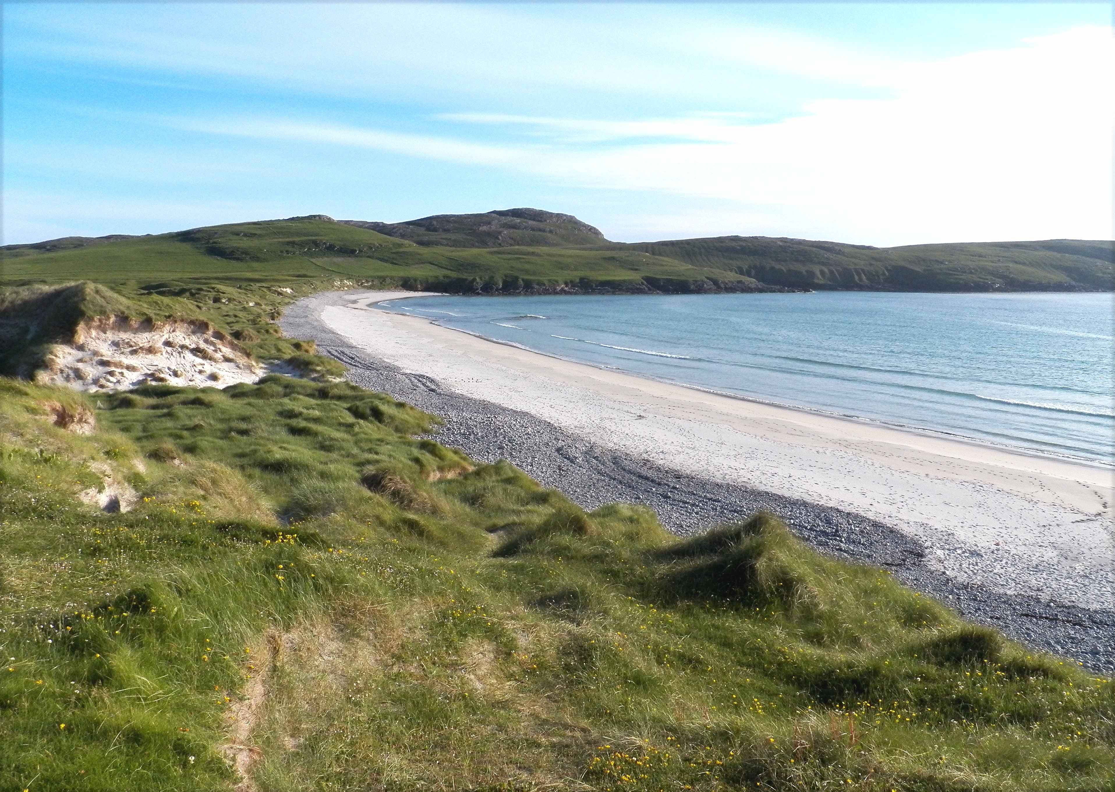
Vatersay is irregularly shaped and has a tombolo: it is composed of two rocky islands (north and south) linked by a sandy isthmus. The isthmus is covered in sand dunes and on either side are large white-sand beaches: Bàgh Siar (West Bay), and Bàgh Bhatarsaigh (Vatersay Bay) to the east. There are a number of beaches backed by sand dunes.[6]
The island is about 3 miles (5 kilometres) from north to south, and the northern section of the island is about 3+1⁄2 mi (5.5 km) from west to east.
Vatersay is linked to the larger island of Barra to the north by a causeway about 200 metres (660 feet) long, which was completed in 1991.[7] This is of great benefit, as the shipping of goods and passenger traffic no longer has to rely on a small passenger ferry boat. Access to school and for emergency services is also much quicker and easier. The causeway is about 2 mi (3 km) by road from Castlebay.
At low tide, the island is also linked to the islet of Uineasan to the east. To the south are the uninhabited islands of Pabbay, Mingulay and Sandray.
Wildlife
Wildlife on the island includes Eurasian otters, seals and grey herons. Bonnie Prince Charlie's flower (Calystegia soldanella), reputedly originating from French seeds dropped by Bonnie Prince Charlie is, in Scotland, found only on Vatersay and Eriskay. Also found on Vatersay are Atlantic puffins.
Archaeology
The island has remains of an Iron Age broch at Dun a' Chaolais overlooking the Sound of Vatersay, and nearby is a passage grave dated to the 3rd millennium BC.[8] There is also a Bronze Age cemetery at Trèseabhaig south of the heights of Heiseabhal Mòr[9] and a cairn built around 1000 BC west of the village of Vatersay.[10] The offshore islet of Bioruaslum has a walled fort that may be of Neolithic provenance.[11]
Ownership
At the end of the nineteenth century, the existing landowner, wanting to use the whole of the island for their own farming purposes, evicted all the existing crofter inhabitants. In 1906, some of these men, the so-called "Vatersay Raiders", returned and took possession of land, claiming that an ancient law allowed a man to acquire land by building a wooden dwelling and lighting a fire on its hearth within a day. However, the landowner Lady Gordon Cathcart took them to court, and they were imprisoned. After much public protest at these events, in 1909, the Congested Districts Board (Scotland) bought Vatersay island and it was divided into 58 crofts.[12][13]
Wrecks

In September 1853, the Annie Jane, a three-masted migrant ship out of Liverpool bound for Montreal, Quebec, Canada, struck rocks off West Beach during a storm. Within ten minutes the ship began to founder and break up, casting 450 people into the raging sea. In spite of the conditions, islanders tried to rescue the passengers and crew.[14]
There were only a few survivors. A small cairn and monument marks the site where the bodies recovered from the sea were buried. An inscription reads:
On 28th September 1853 the ship Annie Jane with emigrants from Liverpool to Quebec was totally wrecked in this bay and threefourths of the crew and passengers numbering about 350 men women and children were drowned and their bodies interred here.
Two Chinese seamen from the SS Idomeneus, which sank on 28 September 1917, are also buried somewhere near the monument. There is a commemorative headstone in Cuier Churchyard.[15]
The remains of a Catalina flying boat that crashed on the slopes of Heiseabhal Beag in 1944 lie in a stream bed near the shore.[16]
See also
- List of islands of Scotland
- Land raid
Notes
- It is also further west than anywhere in England or Wales, but settlements in Counties Fermanagh and Tyrone in Northern Ireland are further west, meaning that Vatersay is not the most westerly settlement in the United Kingdom.
References
- Area and population ranks: there are c. 300 islands over 20 ha in extent and 93 permanently inhabited islands were listed in the 2011 census.
- National Records of Scotland (15 August 2013). "Appendix 2: Population and households on Scotland's Inhabited Islands" (PDF). Statistical Bulletin: 2011 Census: First Results on Population and Household Estimates for Scotland Release 1C (Part Two) (PDF) (Report). SG/2013/126. Retrieved 14 August 2020.
- Haswell-Smith, Hamish (2004). The Scottish Islands. Edinburgh: Canongate. ISBN 978-1-84195-454-7.
- Ordnance Survey. OS Maps Online (Map). 1:25,000. Leisure.
- Mac an Tàilleir, Iain (2003) Ainmean-àite/Placenames. (pdf) Pàrlamaid na h-Alba. Retrieved 26 August 2012.
- THE 20 MOST BEAUTIFUL ISLANDS TO VISIT IN SCOTLAND
- "Undiscovered Vatersay". Isle of Barra. Archived from the original on 23 September 2008. Retrieved 6 November 2008.
- Branigan (2007) p. 65
- Branigan (2007) p. 66
- Branigan (2007) p. 68
- Branigan (2007) p. 67
- Burnett, Ray (1984), Land Raids and the Scottish Left, in Parker, Geoff (ed.), Cencrastus No. 18, Autumn 1984, pp. 2 - 6, ISSN 0264-0856
- "Barra and Vatersay islanders on path to ownership". The Herald. Retrieved 23 January 2021.
- "Annie Jane Memorial - the story". Isle of Vatersay. Archived from the original on 21 November 2008. Retrieved 6 November 2008.
- CWGC Dept of Honour
- "Consolidated Catalina: Vatersay, Heishival Beg". Canmore. Retrieved 13 Nov 2011.
Cited sources
- Branigan, Keith (2007) Ancient Barra: exploring the Archaeology of the Outer Hebrides. Comhairle nan Eilean Siar.
External links
- Panorama of the West Bay on Vatersay (Annie Jane burial cairn and monument) (QuickTime required)
Inhabited islands of the Hebrides | ||
|---|---|---|
| Inner Hebrides |  | |
| Outer Hebrides |
| |
|  | ||||||||||||||||
|
| |||||||||||||||||
| |||||||||||||||||
| |||||||||||||||||
| |||||||||||||||||
| |||||||||||||||||
| |||||||||||||||||
| |||||||||||||||||
На других языках
[de] Vatersay
Vatersay (schottisch-gälisch: Bhatarsaigh) ist die südlichste bewohnte Insel der Äußeren Hebriden in Schottland und über den kurzen Vatersay Causeway mit der Insel Barra (gälisch: Barraigh) verbunden. Die wenigen Einwohner leben in der kleinen, einzigen Ortschaft, die ebenfalls Vatersay heißt, und in Einzelgehöften auf dem südlichen Inselteil.- [en] Vatersay
[es] Vatersay
Vatersay (en gaélico escocés, Bhatarsaigh) es la isla habitada más meridional del grupo de las Hébridas Exteriores, en Escocia, con una población de 94 habitantes (2001). Vatersay constituye asimismo el territorio habitado más occidental de Gran Bretaña.[fr] Vatersay
Vatersay (en gaélique écossais : Bhatarsaigh) est une île du Royaume-Uni située en Écosse, dans l'archipel des Hébrides extérieures. Vatersay est aussi le nom de l'unique village de l'île. L'île est l'une des plus au sud de l'archipel des Hébrides extérieures.[it] Vatersay
Vatersay (in gaelico scozzese: Bhatarsaigh[1] ; 9,6 km²) è un'isola sull'Oceano Atlantico della Scozia nord-occidentale, facente parte dell'arcipelago delle isole Ebridi Esterne e del gruppo delle Western Islands ("Isole Occidentali")[1][2]. È la più meridionale tra le isole abitate delle Western Islands[2] e conta una popolazione di circa 70 abitanti.[1][ru] Ватерсей
Ва́терсей (англ. Vatersay; гэльск. Bhatarsaigh) — самый южный из обитаемых островов архипелага Внешние Гебриды, расположенного вблизи западного побережья Шотландии. Относится к группе островов Барра. Площадь составляет 9,6 км², высшая точка — 190 м над уровнем моря (гора Хешивар-Мор). На севере соединён с островом Барра дамбой, постройка которой была завершена в 1991 году. Население по данным переписи 2001 года составляет 94 человека.Другой контент может иметь иную лицензию. Перед использованием материалов сайта WikiSort.org внимательно изучите правила лицензирования конкретных элементов наполнения сайта.
WikiSort.org - проект по пересортировке и дополнению контента Википедии