geo.wikisort.org - Island
Eriskay (Scottish Gaelic: Èirisgeigh), from the Old Norse for "Eric's Isle", is an island and community council area of the Outer Hebrides in northern Scotland with a population of 143, as of the 2011 census.[2] It lies between South Uist and Barra and is connected to South Uist by a causeway which was opened in 2001. In the same year Ceann a' Ghàraidh in Eriskay became the ferry terminal for travelling between South Uist and Barra. The Caledonian MacBrayne vehicular ferry travels between Eriskay and Ardmore in Barra. The crossing takes around 40 minutes.
| Scottish Gaelic name | Èirisgeigh |
|---|---|
| Pronunciation | [ˈeɾʲiʃkʲej] ( |
| Old Norse name | Eiríksey |
| Meaning of name | Eric's Isle |
| Location | |
 Eriskay Eriskay shown within the Outer Hebrides | |
| OS grid reference | NF795104 |
| Coordinates | 57.07°N 7.29°W |
| Physical geography | |
| Island group | Uist and Barra |
| Area | 703 ha (2+3⁄4 sq mi) |
| Area rank | 63 [1] |
| Highest elevation | Beinn Sgrithean 185.6 m (609 ft) |
| Administration | |
| Sovereign state | United Kingdom |
| Country | Scotland |
| Council area | Comhairle nan Eilean Siar |
| Demographics | |
| Population | 143[2] |
| Population rank | 40 [1] |
| Population density | 20.3/km2 (53/sq mi)[2][3] |
| References | [3][4][5] |
Geography

Although only a small island (about 2+1⁄2 by 1+1⁄2 miles or 4 by 2.5 kilometres) Eriskay has many claims to fame that have made the island well-known far beyond the Hebrides. It is associated with the traditional Hebridean song, the Eriskay Love Lilt; with the Eriskay Pony and the Eriskay jersey (made without any seams). It is the real Whisky Galore! island: it was just off Eriskay that the SS Politician ran aground in 1941 with its famous cargo. On 2 August 1745 the privateer Du Teillay landed Bonnie Prince Charlie with his "seven men of Moidart" on Eriskay to start the "Forty-Five Jacobite Rising". An important early documentary film, Eriskay: A Poem of Remote Lives, made in 1934 by a German traveller, Werner Kissling, was set on the island.
There is a well-stocked shop in Eriskay, a community centre and the Politician Lounge Bar (named after the ship which serendipitously ran aground and famously provided the island with a generous supply of free whisky). St Michael's Roman Catholic Church sits on a hill overlooking the main village on Eriskay. It celebrated its centenary in 2003, having been built by Father Allan MacDonald in 1903. The site of the old church is marked by a memorial garden with a statue of the Virgin Mary, overlooking the Sound of Barra.
Transport
| Caledonian MacBrayne |
|---|
Eriskay is traversed by a number of mountain paths and tracks, and has just a single motor road. The first stretch of that road was built in 1935, funded through proceeds from the first showing in London of the Werner Kissling film.
There is a regular bus service on the island which forms part of the "Spine Route" between Eriskay Slipway and Berneray via South Uist, Benbecula and North Uist. Services are provided by DA Travel with funding from Comhairle nan Eilean Siar.
In 2009 the previous primitive quay facilities at the excellent natural harbour of Acarsaid Mhòr were extended and modernised, with improved vehicular access. Some smaller fishing boats continue—at least if the tides and weather are favourable—to use the shelving bay at Haun (from the Viking for 'harbour'—but scarcely with sufficient shelter to constitute a harbour in practice). Acarsaid Mhòr is also used by visiting yachts.
Crofting
Following the establishment of the first Crofting Commission in the 1880s, the whole of the island, together with the small adjoining Stack Island, were incorporated into the crofting townships—as below—of
- Acarsaid Mhòr – 14 crofts, 10 shares
- Am Baile (Balla) – 16 crofts, 15 shares
- Bun a' Mhuillinn – 10 crofts, 10 shares
- Coilleag – 10 crofts, 10 shares
- Na Hann (Haun) – 6 crofts, 4 shares
- Na Pàirceannan (Parks) – 4 crofts, 4 shares
- Roisinis (Roshinish) – 4 crofts, 6 shares
- Rudha Bàn – 9 crofts, 5 shares
- Total – 73 crofts, 64 shares
The souming (a word originating in the Viking era) for each full share gives the right to put, on the common grazings (the high ground of Beinn Sgrithean and Beinn Stac), ten sheep, two cows and one Eriskay Pony (all plus their 'followers'—young up to one year old). Most crofts have one full share, but many have a half share, and a few have two shares, and one croft has as many as 3 shares.
The crofts are small (typically five hectares or less) and the land is rocky and exposed to harsh weather. These days, very few crofts are actively worked: there is little economic return in relation to the effort, and although there is a strong cultural attachment to the land, the demands and distractions of modern life leave little time for tending livestock and manual work. Much of the best grazing land, the machair of the north west of the island, has been compromised by house-building and the increasing opposition to the free-range grazing of cattle and sheep during the winter. Now, the most actively worked crofts are in the township of Bun a' Mhuillin.
The island's common grazings, and the grazing of croft inbye land during the winter months, are regulated by the Eriskay Grazings Committee, the members of which serve a three-year term, supported by a Grazings Clerk, and according to the Grazings Regulations as provided for in the Crofting Acts.[6]
Community buy-out
After a protracted campaign local residents took control of the island on 30 November 2006 in a community buy-out. The previous landowners, a sporting syndicate, sold the assets of the 372-square-kilometre (144 sq mi) estate including Benbecula, South Uist and Eriskay for £4.5 million to a community-owned organisation known as Stòras Uibhist which was set up to purchase the land and to manage it in perpetuity.[7][8][9]
Emigration

Many Eriskay families have had to leave the island in recent years in search of work and some historic island families have few or no descendants left on the island. An example of these families is the MacInnes who were a prominent island family at the time of the Kissling film but now number just four members of the extended family dwelling on the island, and active in crofting, shell-fishing, building work, as well contributing to the community.
Many of those who leave for the mainland are young as—in common with remoter rural areas generally—there are few work opportunities and limited access to further or higher education.
The island's population was 143, as recorded by the 2011 census[2]—an increase of 7.5% since 2001, when there were 133 usual residents.[10] During the same period Scottish island populations as a whole grew by 4% to 103,702.[11]
Tourism
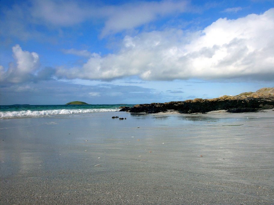
As of 2010[update] there were no hotels, two or three bed-and-breakfast establishments, and until recently few self-catering cottages or houses. Since the completion in 2001 of the causeway to South Uist and the inauguration of the vehicle ferry to Barra, a number of properties have been professionally renovated or purpose-built as holiday accommodation. The machair and beaches from Coilleag a' Phrionnsa to Rudha Bàn are increasingly popular with visitors travelling with their motor-homes.
The island is home to a herd of Eriskay Ponies owned and maintained by members of Comann Each nan Eilean – The Eriskay Pony Society, founded in 1972.[12] The ponies are bound by crofting regulations and are brought to the hill grazings in spring, and back down into the township for the winter. They graze and roam around the island to whichever part is most comfortable depending on the climate. Although the ponies have a laid-back temperament and are accustomed to humans, they should be approached with care and visitors should refrain from feeding them, as this can be harmful to the animals.
Wildlife
Sea bindweed, which is not native to the Hebrides, grows on the island. Its presence there is said to stem from the arrival of the "Bonnie Prince", who accidentally dropped the seeds when he pulled a handkerchief from his pocket.[13]
Residents and visitors
- Allan MacDonald (1859–1905), a Roman Catholic priest, important figure in Scottish Gaelic literature, and activist for crofters' rights, died and was buried on Eriskay.
- Prince Charles and Princess Diana visited the island during their tour of the Western Isles in July 1985.
- Father Calum (Malcolm Joseph) MacLellan (1926–2012) priest, appearing in series 5 and 6 of An Island Parish, first vice-convener of Comhairle nan Eilean Siar.[14]
See also
References
- Area and population ranks: there are c. 300 islands over 20 ha in extent and 93 permanently inhabited islands were listed in the 2011 census.
- National Records of Scotland (15 August 2013). "Appendix 2: Population and households on Scotland's Inhabited Islands" (PDF). Statistical Bulletin: 2011 Census: First Results on Population and Household Estimates for Scotland Release 1C (Part Two) (PDF) (Report). SG/2013/126. Retrieved 14 August 2020.
- Haswell-Smith, Hamish (2004). The Scottish Islands. Edinburgh: Canongate. ISBN 978-1-84195-454-7.
- Ordnance Survey. OS Maps Online (Map). 1:25,000. Leisure.
- Mac an Tàilleir, Iain (2003) Ainmean-àite/Placenames. (pdf) Pàrlamaid na h-Alba. Retrieved 26 August 2012.
- Regulations for the Management of the Isle of Eriskay Common Grazings, 14 July 1997, as amended in 2010
- "Land buyout reality for islanders". BBC News. 30 November 2006. Retrieved 4 January 2010.
- "Stòras Uibhist: Going Forward Together" storasuibhist.com. Retrieved 26 June 2010.
- The quiet revolution. (19 January 2007) Broadford. West Highland Free Press.
- General Register Office for Scotland (28 November 2003) Scotland's Census 2001 – Occasional Paper No 10: Statistics for Inhabited Islands. Retrieved 26 February 2012.
- "Scotland's 2011 census: Island living on the rise". BBC News. Retrieved 18 August 2013.
- "Island | Comann Each nan Eilean". Comann nan Each. Retrieved 16 September 2021.
- Drainey, Nick (19 April 2009) "Walk of the week: Beinn Sciathan (Ben Scrien), Eriskay" Scotland on Sunday. Retrieved 17 September 2010.
- Elizabeth McMeekin (16 July 2012). "Father Malcolm Joseph MacLellan". The Herald. Retrieved 24 October 2013.
External links
- Am Paipear Community Newspaper*"Eriskay, 1934" Video (Werner Kissling)
- Legislation relating to construction of causeway
- National Library of Scotland: SCOTTISH SCREEN ARCHIVE (selection of archive films about Eriskay)]
- Uist & Eriskay Community News and Information Resource
- Scotsman photos of royal visit to Eriskay in 1985
Inhabited islands of the Hebrides | ||
|---|---|---|
| Inner Hebrides |  | |
| Outer Hebrides | ||
|  | ||||||||||||||||
|
| |||||||||||||||||
| |||||||||||||||||
| |||||||||||||||||
| |||||||||||||||||
| |||||||||||||||||
| |||||||||||||||||
| |||||||||||||||||
Authority control | |
|---|---|
| General | |
| National libraries | |
На других языках
[de] Eriskay
Die Insel Eriskay (schottisch-gälisch: Èirisgeigh [.mw-parser-output .IPA a{text-decoration:none}ˈeɾʲiʃkʲej], von altnord. Eiríksey, dt. „Eiríkrs Insel“) gehört zu den Äußeren Hebriden in Nordschottland. Sie gehört zur Civil parish South Uist. Sie liegt zwischen South Uist und Barra und ist mit South Uist durch den 2002 eröffneten Eriskay Causeway, einen Straßendamm, verbunden. Im gleichen Jahr wurde eine Fährstrecke zwischen Eriskay und Barra eröffnet. Die neue Fähre verkehrt zwischen Ceann a’ Gharaidh auf Eriskay und Ardmore auf Barra. Die Überfahrt dauert rund 40 Minuten. 2011 lebten 143 Personen auf der Insel.[1]- [en] Eriskay
[fr] Eriskay
Eriskay (en gaélique écossais : Eirisgeidh, API : /ˈeɾʲiʃkʲej/) est une île du Royaume-Uni située en Écosse, dans l'archipel des Hébrides extérieures.[it] Eriskay
Eriskay (in gaelico scozzese: Eirisgeidh[1]; Eiriosgaigh[2][3] o Èirisgeigh; 2, 7 km²; 130 ab. circa) è un'isola della Scozia nord-occidentale, facente parte dell'arcipelago delle Ebridi Esterne (Outer Hebrides) e situata nel Sound of Barra[3] (Oceano Atlantico).[ru] Эрискей
Э́рискей (англ. Eriskay; гэльск. Èirisgeigh) — остров в составе архипелага Внешние Гебриды, расположенного вблизи западного побережья Шотландии. Площадь составляет 7,03 км². Расположен между островами Саут-Уист и Барра; с Саут-Уист соединён дамбой, строительство которой было завершено в 2001 году. Имеется паромная связь с островом Барра, путь занимает около 40 мин.Другой контент может иметь иную лицензию. Перед использованием материалов сайта WikiSort.org внимательно изучите правила лицензирования конкретных элементов наполнения сайта.
WikiSort.org - проект по пересортировке и дополнению контента Википедии