geo.wikisort.org - Island
Grimsay (Scottish Gaelic: Griomasaigh) is a tidal island in the Outer Hebrides of Scotland.
| Scottish Gaelic name | Griomasaigh |
|---|---|
| Old Norse name | Grímsey |
| Meaning of name | ON: Grim's Island |
| Location | |
 Grimsay Grimsay shown within the Outer Hebrides | |
| OS grid reference | NF855572 |
| Coordinates | 57.49°N 7.24°W |
| Physical geography | |
| Island group | Uist and Barra |
| Area | 833 ha (3+1⁄4 sq mi) |
| Area rank | 58 [1] |
| Highest elevation | 22 m (72 ft) |
| Administration | |
| Sovereign state | United Kingdom |
| Country | Scotland |
| Council area | Outer Hebrides |
| Demographics | |
| Population | 169[2] |
| Population rank | 36 [1] |
| Population density | 20/km2 (52/sq mi)[2][3] |
| Largest settlement | Bàgh Mòr and Ceallan |
| References | [3][4] [5] |
Geography
Grimsay is the largest of the low-lying stepping-stones which convey the Oitir Mhòr (North Ford) causeway, a 5-mile (8-kilometre) arc of single track road linking North Uist and Benbecula via the western tip of Grimsay.[6] Until it opened in 1960,[7] a ferry linked Carinish (on North Uist) with Gramsdale (on Benbecula), but could only operate at high tide.[8] There was also a ford which could only be crossed close to low water, usually only with a guide.[8] For significant parts of each day the North Ford was too wet to ford and not wet enough to cross by ferry.[8] East of Grimsay lie several smaller islands including Ronay which was inhabited until 1931.[3]
Inhabitants
The island's population was 169 as recorded by the 2011 census[2] a drop of over 15% since 2001 when there were 201 usual residents.[9] During the same period Scottish island populations as a whole grew by 4% to 103,702.[10] The main settlements are Baymore (Bàgh Mòr) and Kallin (Ceallan) at the eastern end of the island. Grimsay has a harbour at Kallin, which is the base to a sizeable shellfish industry,[6] the island's main industry, mostly for lobster, prawns and scallops. Also in Kallin is The Boatshed, a marine repair facility which promotes traditional skills, and employs a full-time boatbuilder and trainee.[11] Three generations of Stewart family built as many as 1,000 boats from three sheds on Grimsay.[11] Grimsay is encircled by a single-track road that links most of the island's small croft and fishing settlements together.
History
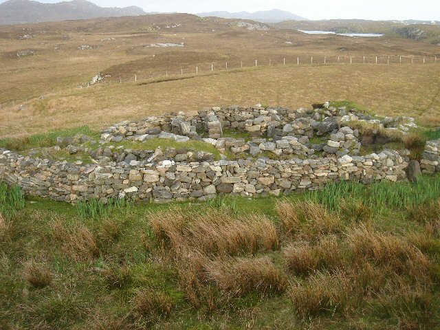
There is a fine example of an Iron-Age wheelhouse on the northeast coast of the island at Bagh nam Feadag.[12] It is one of the best examples of a wheelhouse on North Uist but does not appear on Ordnance Survey maps.[13]
 Bagh Mòr on Grimsay, with Ronay in distance
 A wheelhouse on Grimsay

See also
Footnotes
- Area and population ranks: there are c. 300 islands over 20 ha in extent and 93 permanently inhabited islands were listed in the 2011 census.
- National Records of Scotland (15 August 2013). "Appendix 2: Population and households on Scotland's Inhabited Islands" (PDF). Statistical Bulletin: 2011 Census: First Results on Population and Household Estimates for Scotland Release 1C (Part Two) (PDF) (Report). SG/2013/126. Retrieved 14 August 2020.
- Haswell-Smith, Hamish (2004). The Scottish Islands. Edinburgh: Canongate. ISBN 978-1-84195-454-7.
- Ordnance Survey: Landranger map sheet 22 Benbecula & South Uist (Map). Ordnance Survey. 2008. ISBN 9780319226223.
- Mac an Tàilleir, Iain (2003) Ainmean-àite/Placenames. (pdf) Pàrlamaid na h-Alba. Retrieved 26 August 2012.
- "Overview of Grimsay". Gazetteer for Scotland. Retrieved 22 July 2007.
- Sullivan, Mike; Sullivan, Mike; Pickering, Timothy (2010). The Outer Hebrides: Sea Kayaking Around the Isles & St Kilda. ISBN 9781906095093.
- "Feature Page: Grimsay". Undiscovered Scotland. Retrieved 22 July 2007.
- General Register Office for Scotland (28 November 2003) Scotland's Census 2001 – Occasional Paper No 10: Statistics for Inhabited Islands. Retrieved 26 February 2012.
- "Scotland's 2011 census: Island living on the rise". BBC News. Retrieved 18 August 2013.
- "The Grimsay Boatshed". acrosstheminch.org. Retrieved 17 December 2013.
- "Grimsay Wheelhouse". Alasdair McKenzie. Retrieved 30 November 2009.
- "Grimsay Wheelhouse". Outer Hebrides Tourism Industry Association. Retrieved 17 December 2013.
|  | ||||||||||||||||
|
| |||||||||||||||||
| |||||||||||||||||
| |||||||||||||||||
| |||||||||||||||||
| |||||||||||||||||
| |||||||||||||||||
| |||||||||||||||||
На других языках
[de] Grimsay
Grimsay (schottisch-gälisch: Griomasaigh) ist eine Insel der Äußeren Hebriden von Schottland, über Dämme mit North Uist und Benbecula verbunden. 2011 lebten 169 Personen auf Grimsay.[1]- [en] Grimsay
[fr] Grimsay
Grimsay (en gaélique écossais : Griomasaigh) est une île du Royaume-Uni située en Écosse dans l'archipel des Hébrides extérieures.Другой контент может иметь иную лицензию. Перед использованием материалов сайта WikiSort.org внимательно изучите правила лицензирования конкретных элементов наполнения сайта.
WikiSort.org - проект по пересортировке и дополнению контента Википедии