geo.wikisort.org - Mountains
Turrialba Volcano is an active volcano in central Costa Rica that has been explosively eruptive in recent years including 2016 [2] and in January, March and April 2017.[3][4][5][6] Visitors used to be able to hike down into the main crater, but increased volcanic activity in 2014–17, resulting in large clouds of volcanic ash, caused the surrounding Turrialba Volcano National Park to close. However, with the subsiding of the eruptions, the park and volcano reopened on December 4, 2020.[7][8]
| Turrialba Volcano | |
|---|---|
 Turrialba volcano while in eruption, October 2014 | |
| Highest point | |
| Elevation | 3,340 metres (10,958 ft) |
| Coordinates | 10°1′5″N 83°45′50″W |
| Geography | |
 Turrialba Volcano Cartago, Costa Rica | |
| Parent range | Cordillera Central |
| Geology | |
| Age of rock | 1.5 million years |
| Mountain type | Stratovolcano |
| Last eruption | 2022[1] |
| Climbing | |
| Easiest route | hike |
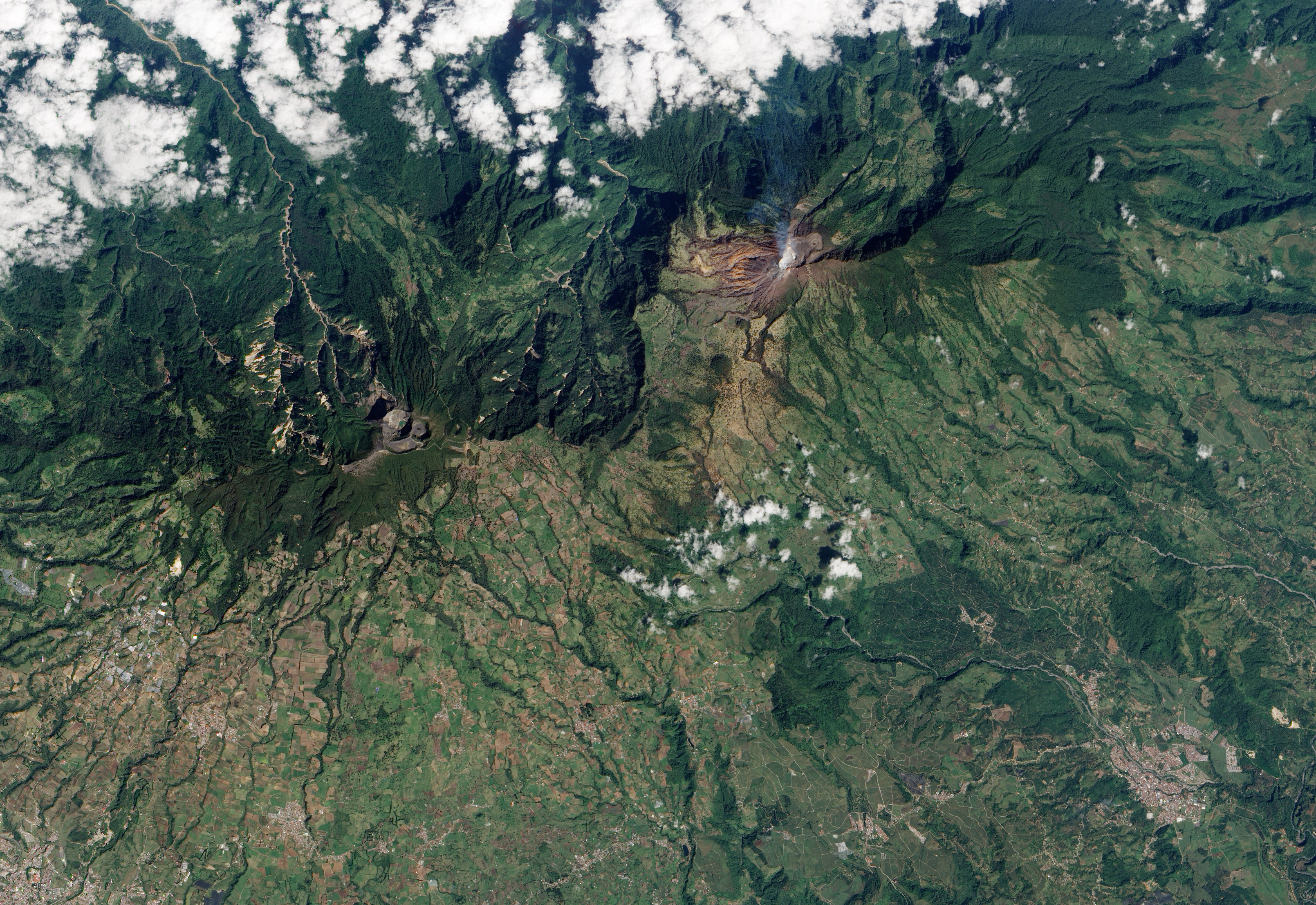
The stratovolcano is 3,340 m (10,958 ft) high and is about 45 minutes from the Atlantic slope town of Turrialba. The summit has three craters, the largest of which has a diameter of 50 m (160 ft).[9] Turrialba is adjacent to Irazú and both are among Costa Rica's largest volcanoes. Turrialba has had at least five large explosive eruptions in last 3500 years. The volcano is monitored by the Deep Earth Carbon Degassing Project.[10]
On clear days both the Pacific Ocean and Caribbean Sea can be seen from the summit. Below the summit is a mountain range and montane forest, with ferns, bromeliads, lichens and mosses. Most of the forest is either primary or secondary forest.[11]
The volcano is named after its canton, Turrialba, in Costa Rica's Cartago Province. There is no clear consensus on the origin of the name Turrialba, but historians disagree with attempts to attribute the name to the patronym Torrealba (from Aragon in Spain) or from the Latin Turris alba (white tower). The general consensus is that Turrialba derives from the local Indian (Huetar language), but there is no agreement on its actual roots.
Activity
- During the 19th century, the volcano erupted and emitted ash several times (1847, 1853, 1855, 1859, 1866), producing pyroclastic flows. The last major eruption was in 1866.[12]
- Small signs of activity started in 1996.
- In January 2001, the volcano reported increased activity, displaying strong fumarole activity at the central craters. The volcanic activities have increased since 2005.
- On March 31, 2017, the volcano started to show some activity with ash eruptions.[13]
- The National Park area opened for visitors was closed from 2009 to 2011.

- On January 8, 2010, a phreatic eruption occurred, creating a new opening near the crater on the southwest, and the temperature increased from 200 to 600 °C (392 to 1,112 °F). Two villages, La Central and El Retiro, were evacuated.[14]
- On January, 2012 a new opening on the west of the crater was created after a phreatic eruption.
- On April 12, 2012, a small eruption occurred.[15]
- On May 21, 2013, at 08:52, a gas explosion widened several openings near the main crater that appeared in 2010 and 2012.[16]
- In July 2013 researchers found that tremors around the area increased from about twenty earthquakes a day, to up to thirty per hour.[17]
- On October 17, 2014, the quantity of tremors increased from around 50-100 a day, to 200 a day.[18]
- On October 29, 2014, at around 10:10, a tremor started and kept constant, until a phreatic eruption occurred around 23:10 at the west opening that appeared in January 2012. This eruption sent a large amount of volcanic material to areas up to 40 km (25 mi) away. Many citizens reported ash falling on their properties and a strong odor of sulphur in the cantons of Vázquez de Coronado, Goicoechea, Moravia, Desamparados, Aserrí, Escazú, Santa Ana, Montes de Oca, Tibás, Alajuelita, Puriscal, San José in the province of San José, La Union in the province of Cartago and Santo Domingo and Heredia, in the province of Heredia.[19]
March 2015
- On March 12, 2015, eruptions at around 11:00 and 14:12 sent ashes through all the Central Valley, it is regarded as the most significant activity since 1996.[20] The Juan Suantamaría and Tobías Bolaños international airports were closed due to visibility being less than 100 meters.[21]
- On March 13, 2015, an eruption occurred at 21:07.
May 2015
- On May 4, 2015, an eruption occurred at 15:24.[22]

May 2016
An eruption occurred on May 21, 2016. It was characterized by one resident as the largest since 2010. Ash fell as far away as the capital, San Jose, and at least 500 people went to hospitals complaining of breathing problems. Flights into San Jose were cancelled due to concerns about ash.[23]
September 2016
On September 19, at 02:54 an eruption lasting around fifteen minutes was the first event of many through the day that eventually covered the metropolitan area with ash. There were events at 11:30, 14:40, 15:34.
The events continued through September 20 with an eruption at 06:20.
Airports in the metropolitan area were closed.[24]
See also
References
- Turrialba at Smithsonian Institution's Global Volcanism Program website
- "UPDATE: Eruption of Turrialba Volcano closes airport, launches ash, rocks 4 km high". 19 September 2016.
- "Ashes from Turrialba Volcano's explosions reach San José, Heredia". 30 March 2017.
- "UPDATE: Green alert declared as Turrialba Volcano ashfall intensifies". 5 January 2017.
- "Costa Rica's Turrialba Volcano resumes vapor, ash explosions". 31 January 2017.
- "Turrialba Volcano Near Cartago, Costa Rica Back in Action After Calm Spell - Costa Rica Star News". 3 April 2017.
- Zúñiga, Alejandro (19 November 2020). "Costa Rica announces reopening of Turrialba Volcano National Park". The Tico Times. Retrieved 19 November 2020.
- "After eight years, Turrialba Volcano National Park reopens to the public -". 5 December 2020.
- Stater, Adam. "The Turrialba Volcano's Craters".
- "DECADE Installations at Turrialba and Poás". Deep Carbon Observatory. Retrieved 26 September 2016.
- Stater, Adam. "Forest Types, Turrialba Volcano".
- "El Turrialba ha hecho erupción seis veces en últimos 3.500 años".
- "Actividad sísmica aumenta en el volcán Turrialba".
- "Erupciones abren dos nuevos cráteres en volcán Turrialba".
- "Volcán Turrialba hizo pequeña erupción".
- "Erupción de ceniza en volcán Turrialba ensanchó boquetes".
- "Volcán Turrialba pasó de 20 sismos por día a 30 por hora".
- "Ceniza del Turrialba alcanza a un millón de habitantes".
- "Volcán Turrialba hace erupción y provoca intensa caída de ceniza en los alrededores" [Turrialba Volcano erupts and a lot of ash fell in the surrounding areas] (in Spanish).
- "Volcán Turrialba registra la erupción más importante desde 1996" [Most important eruption since 1996 registered at Turrialba Volcano.] (in Spanish).
- "Cierran Aeropuerto Juan Santamaría debido a caída de ceniza" [Juan Santamaria airport closed due to falling ashes.] (in Spanish).
- "Costa Rica's Turrialba Volcano erupts, forcing capital airport to temporarily close". 4 May 2015.
- "Volcano ash covers Costa Rica towns". BBC. London. Retrieved 2016-05-21.
- "Eruption of Turrialba Volcano closes airport launches ash, rocks 4 km high". Tico Times. Costa Rica. Retrieved 2016-09-20.
- "Turrialba". Global Volcanism Program. Smithsonian Institution.
External links
![]() Media related to Turrialba volcano at Wikimedia Commons
Media related to Turrialba volcano at Wikimedia Commons
- Costa Rican Vulcanologic and Seismologic Observatory: Turrialba
- Webcam of the Vulcanological and Seismological Observatory of National University of Costa Rica.
Volcanoes of Costa Rica | ||
|---|---|---|
| Cordillera de Guanacaste | ||
| Cordillera de Tilarán | ||
| Cordillera Central | ||
Mountains of Costa Rica | ||
|---|---|---|
| ||
| Guatemala |  | |
|---|---|---|
| El Salvador | ||
| Nicaragua | ||
| Costa Rica |
| |
| Panama |
| |
Note: volcanoes are ordered from north-west to south-east. | ||
На других языках
[de] Turrialba (Vulkan)
Der Turrialba ist ein Vulkan in der zentralamerikanischen Republik Costa Rica.- [en] Turrialba Volcano
[es] Volcán Turrialba
El volcán Turrialba es un estratovolcán complejo activo de Costa Rica, ubicado en el distrito de Santa Cruz, en el cantón de Turrialba, provincia de Cartago, a 24 km de la ciudad del mismo nombre. Es el más oriental de los volcanes de la cordillera Volcánica Central, y da nombre al parque nacional que le envuelve, el parque nacional Volcán Turrialba. Con su cumbre situada a 3340 msnm, es el segundo volcán más alto de Costa Rica, superado solo por el Volcán Irazú (3432 msnm). Su área consta de aproximadamente 500 km².[fr] Turrialba
Le Turrialba est un stratovolcan actif du Costa Rica, situé dans le canton du même nom. Son sommet est tronqué par une caldeira, qui contient trois cratères, dont un actif (fort dégazage, ouverture de nouvelles fissures), placé sous haute surveillance.[it] Turrialba (vulcano)
Il Turrialba è uno stratovulcano attivo della Costa Rica, situato nel cantone che porta il suo stesso nome. La sommità del vulcano è formata da una caldera che contiene tre crateri, di cui uno attivo. Dopo più di un secolo di inattività, nel gennaio del 2001 ha ripreso un'attività che si è protratta con fasi alterne fino ai nostri giorni.[ru] Турриальба (вулкан)
Турриальба (исп. Turrialba) — действующий вулкан в Северной Америке, находится в Коста-Рике.Другой контент может иметь иную лицензию. Перед использованием материалов сайта WikiSort.org внимательно изучите правила лицензирования конкретных элементов наполнения сайта.
WikiSort.org - проект по пересортировке и дополнению контента Википедии