geo.wikisort.org - Mountains
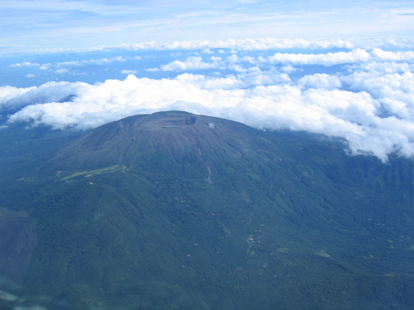
The Santa Ana Volcano or Ilamatepec (Spanish: volcán de Santa Ana) is a large stratovolcano located in the Santa Ana department of El Salvador. At 2,381 metres (7,812 ft) above sea level, it is the highest volcano in the country. It is located immediately west of Coatepeque Caldera.
| Santa Ana Volcano | |
|---|---|
 | |
| Highest point | |
| Elevation | 2,381 m (7,812 ft)[1] |
| Coordinates | 13°51′11″N 89°37′48″W[1] |
| Geography | |
 Santa Ana Volcano Location in El Salvador | |
| Location | El Salvador |
| Parent range | Cordillera de Apaneca |
| Geology | |
| Mountain type | Stratovolcano |
| Last eruption | 2005 |
The volcano was the inspiration for one of the active volcanoes in Antoine de Saint-Exupéry's famous French novella (The Little Prince), based on his life with his Salvadoran wife Consuelo de Saint Exupéry, who was The Rose in the story.[citation needed]
Geography

The summit of Santa Ana features four nested calderas and volcanic craters, with the innermost containing a small crater lake. Collapse of the summit during the late Pleistocene (inferring from underlying soil samples, the upper age limit is no more than 57,000 years ago) produced a massive debris avalanche that reached the Pacific Ocean, forming the Acajutla Peninsula. Subsequent eruptions have largely rebuilt the edifice.[1]
There have been numerous historical eruptions since the 16th century, both at the summit and from cinder cones on the lower flanks, and also the flank vents of San Marcelino located east of Santa Ana. The San Marcelino vents erupted in 1722 and flowed eastwards for 11 km, destroying the village of San Juan Tecpan.
In October, 2005, the volcano erupted, killing at least two people, injuring seven people, forcing many people to flee their villages. The volcano spat rocks for over 1.5 km (0.93 mi) with rocks the size of cars.[2] The eruption contributed to the damage from Hurricane Stan. The most recent previous eruption had been in 1904.
Climate
The climate on the northeast facing slope of the volcano sees substantial rainfall in the summer months. Located at 13.9 N, 89.6 W, altitude : 1770 m, the climate is classified as a subtropical highland climate (Köppen Cwb).
| Climate data for Santa Ana, Volcano; 13.9 N, 89.6 W, altitude : 1771 m | |||||||||||||
|---|---|---|---|---|---|---|---|---|---|---|---|---|---|
| Month | Jan | Feb | Mar | Apr | May | Jun | Jul | Aug | Sep | Oct | Nov | Dec | Year |
| Average high °C (°F) | 19.3 (66.7) |
20.6 (69.1) |
23.3 (73.9) |
23.2 (73.8) |
22.7 (72.9) |
21.6 (70.9) |
21.6 (70.9) |
21.6 (70.9) |
20.9 (69.6) |
20.0 (68.0) |
19.2 (66.6) |
18.9 (66.0) |
21.1 (69.9) |
| Daily mean °C (°F) | 14.7 (58.5) |
15.3 (59.5) |
17.0 (62.6) |
17.7 (63.9) |
17.9 (64.2) |
17.2 (63.0) |
17.1 (62.8) |
17.1 (62.8) |
16.9 (62.4) |
16.2 (61.2) |
15.2 (59.4) |
14.7 (58.5) |
16.4 (61.6) |
| Average low °C (°F) | 11.2 (52.2) |
11.6 (52.9) |
12.8 (55.0) |
13.9 (57.0) |
14.6 (58.3) |
14.3 (57.7) |
14.0 (57.2) |
14.0 (57.2) |
14.2 (57.6) |
13.6 (56.5) |
12.7 (54.9) |
11.8 (53.2) |
13.2 (55.8) |
| Average precipitation mm (inches) | 8 (0.3) |
5 (0.2) |
19 (0.7) |
64 (2.5) |
223 (8.8) |
427 (16.8) |
417 (16.4) |
393 (15.5) |
452 (17.8) |
208 (8.2) |
48 (1.9) |
10 (0.4) |
2,274 (89.5) |
| Source: HKO[3] | |||||||||||||
See also
- List of volcanoes in El Salvador
- List of stratovolcanoes
References
- Notes
- "Santa Ana". Global Volcanism Program. Smithsonian Institution. Retrieved 2018-02-04.
- "El Salvador volcano causes chaos". BBC News. October 2, 2005. Retrieved 2018-02-04.
- "Climatological Normals of Los Andes". Hong Kong Observatory. Retrieved 2012-03-13.
- Sources
- Sheets P D, 2004. Apocalypse then: social science approaches to volcanism, people, and cultures in the Zapotitan Valley, El Salvador. Rose W. I., Bommer J. J., Lopez D. L., Carr M. J., Major J. J. (eds), Natural Hazards in El Salvador. Bolder, Colorado, Geological Society of America Special Paper 375, pp 109–120.
- Siebert, L. Kimberly, P., and Pullinger, C.R, 2004, The voluminous Acajulta debris avalanche from Santa Ana Volcano, western El Salvador, and comparison with other Central American edifice-failure evens, in Rose, W.I. et al., Natural Hazards in El Salvador. Boulder, Colorado, Geological Society of America Special Paper 375, pp 5–23.
External links
| Guatemala |  | |
|---|---|---|
| El Salvador | ||
| Nicaragua | ||
| Costa Rica |
| |
| Panama |
| |
Note: volcanoes are ordered from north-west to south-east. | ||
На других языках
[de] Santa Ana (Vulkan)
Santa Ana (spanisch: volcán Santa Ana) oder auch Ilamatepec ist ein Vulkan im Departamento Santa Ana, El Salvador.- [en] Santa Ana Volcano
[es] Volcán Ilamatepec
El cerro de Santa Ana, ubicado en el departamento homónimo o lamatepec [1] en El Salvador, tiene una elevación de 2.381 msnm y es el más alto de este país.[2] Sus últimas erupciones ocurrieron en 1904, en 1920 y en 2005[3] según el Índice de explosividad volcánica este volcán es nivel 3 de 8.[fr] Santa Ana (volcan)
Le volcan de Santa Ana est situé dans la cordillère d'Apaneca au Salvador, dans le département de Santa Ana, près de la ville de Santa Ana. Il est aussi appelé par son nom nahuatl Ilamatepec. Avec ses 2 381 mètres d'altitude, c'est le plus haut volcan du pays.[ru] Санта-Ана (вулкан)
Санта-Ана (исп. Santa Ana) — вулкан в Сальвадоре.Другой контент может иметь иную лицензию. Перед использованием материалов сайта WikiSort.org внимательно изучите правила лицензирования конкретных элементов наполнения сайта.
WikiSort.org - проект по пересортировке и дополнению контента Википедии