geo.wikisort.org - Mountains
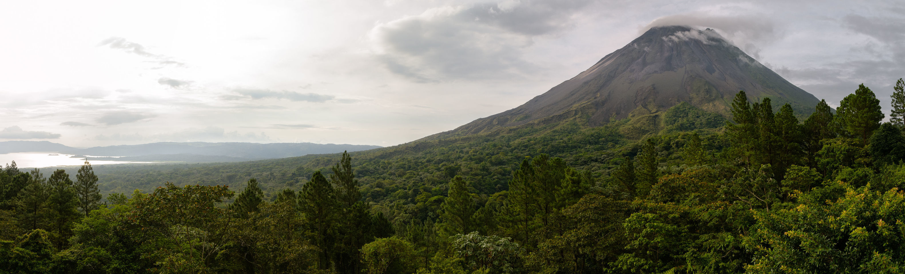
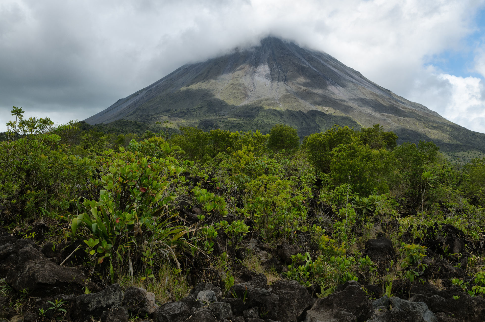
Arenal Volcano (Spanish: Volcán Arenal) is an active andesitic stratovolcano in north-western Costa Rica around 90 km (56 mi) northwest of San José, in the province of Alajuela, canton of San Carlos, and district of La Fortuna. The Arenal volcano measures at least 1,633 metres (5,358 ft) high.[2] It is conically shaped with a crater 140 metres (460 ft) in diameter. Geologically, Arenal is considered a young volcano and it is estimated to be less than 7,500 years old.[1] It is also known as "Pan de Azúcar", "Canaste", "Volcan Costa Rica", "Volcan Río Frío" or "Guatusos Peak".[1]
This article needs additional citations for verification. (June 2009) |
| Arenal Volcano | |
|---|---|
 | |
| Highest point | |
| Elevation | 1,670 m (5,480 ft)[1] |
| Coordinates | 10°27′48″N 84°42′12″W |
| Geography | |
 Arenal Volcano Costa Rica | |
| Location | Alajuela Province, Costa Rica |
| Geology | |
| Age of rock | 7,000 years old |
| Mountain type | Stratovolcano |
| Last eruption | 1968 to 2010 |
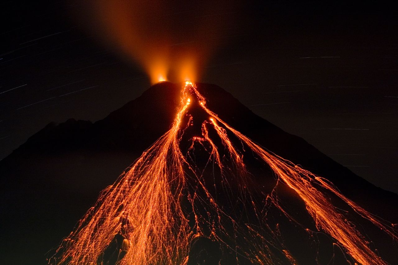
The volcano was dormant for hundreds of years and exhibited 2 craters at its summit, with minor fumaroles activity, covered by dense vegetation. In 1968 it erupted unexpectedly, destroying the small town of Tabacón. Due to the eruption three more craters were created on the western flanks but only one of them still exists today. Arenal's eruption from 1968 to 2010 is the tenth longest duration volcanic eruption on Earth since 1750.[3] Since 2010, Arenal has been dormant.[4]
Geographic setting and description
Arenal is one of seven historically active Costa Rican volcanoes along with Poás, Irazú, Miravalles, Orosí, Rincón de la Vieja complex, and Turrialba. It was Costa Rica's most active volcano until 2010, and one of the ten most active volcanoes in the world. It has been studied by seismologists for many years. The volcano is located at the center of Arenal Volcano National Park in the northern zone of the country, 15 kilometres (9.3 mi) southwest of the La Fortuna district in San Carlos (canton), Costa Rica.[5]
Arenal Volcano area is an important watershed for the Arenal Lake Reservoir. The reservoir's water is used for hydroelectric power. It is also connected to the national system.[6]
Arenal has several eruptive vents.[7] Chato is a dormant stratovolcanic cone. It is believed that Chato first erupted 38,000 years ago during the Pleistocene period and last erupted about 3,500 years ago.[1] Chatito is a lava dome with an elevation of 1,100 metres (3,609 ft). Espina is another lava dome.[1]
Geologic history
Arenal is the youngest and most active of all the volcanoes in Costa Rica. Scientists have been able to date its activity back more than 7000 years. The area remained largely unexplored until 1937, when a documented expedition took place to reach the summit.[8] It has been considered eruptive since 1968.[1]
July 29, 1968
On Monday, July 29, 1968, at 7:30 am, the Arenal Volcano suddenly and violently erupted. The eruptions continued unabated for several days, burying over 15 square kilometers (5.8 sq mi) under rocks, lava and ash. When it was finally over, the eruptions had killed 87 people and buried 3 small villages – Tabacón, Pueblo Nuevo and San Luís – and affected more than 232 square kilometers (90 sq mi) of land. Crops were spoiled, property was ruined, and large numbers of livestock were killed.[9]
At the height of its ferocious activity, the volcano flung giant rocks – some weighing several tons – more than a kilometer (half a mile) away at a rate of 600 meters per second (2,000 ft/s; 1,300 mph).[citation needed] These explosions would go on to form three new active craters.
As the three towns were destroyed on the western side of the volcano, a town by the name of El Borio on the east side was untouched and unharmed. It is a popular myth that after the volcano ceased to erupt, El Borio was renamed La Fortuna, which means "the fortunate", referring to its luckiness that the volcano erupted to the west and not the east. However, the town was renamed La Fortuna by its residents before the 1968 eruption. "The Fortune" refers to the flat, fertile lands in the area, which are unlike the rough, mountainous terrain which surrounds most of the Arenal volcano. If the town had been renamed "The Fortunate", it would have been called "El Afortunado."
June 1975
Between the 17th and the 21st of June 1975 several avalanches went down from one of the craters. The vegetation along Tabacon River was destroyed and a great amount of material was deposited on the riverbed. Four strong explosions also blew large amounts of ash into the sky. The ash was spread within a distance of 26 kilometers (16 mi).
March 1996
At this time the volcano started to produce regular lava flows, accompanied by intermittent explosions of gases. This was the regular activity of the volcano until May 5, 1998.
May 5, 1998
The Arenal Volcano experienced a series of large eruptions on Tuesday afternoon, May 5, 1998. The first ratchet eruption was recorded at 1:05 p.m. when part of the northwest wall of the crater fell apart. Large amounts of lava, rocks, and ash flew out of the volcano during this explosion. Another eruption took place at 2:20 p.m. with material emerging from the same part of the volcano.
A specialist from the Costa Rica Volcanic and Seismic Observatory explained that the eruptions are nothing unusual for the volcano. Nevertheless, during this occasion, the amount of lava within the crater was significantly greater than normal and therefore more material was poured out. This time a landslide took place, too, as a part of the crater wall falling apart on the northwest side. This phenomenon occurs sporadically, although this time the consequences were greater than usual.
As a normal precaution, authorities declared a red alert, closed the road between La Fortuna and Tilarán, which runs around the north side of the volcano, and evacuated approximately 450 people (mostly tourists) from the immediate area, including several hotels and tourism-oriented businesses. There were no reports of injuries caused by the volcanic activity.
At 5:20 p.m. on Tuesday the volcano was still discharging material, but activity had decreased significantly.
May 7, 1998
The eruptions of May 7, 1998, damaged 2 square kilometers (0.77 sq mi) and destroyed a 400-by-100-meter (1,310 by 330 ft) area of green forest in the vicinity of Arenal Volcano. A fissure, 500 meters (1,600 ft) long and 10 meters (33 ft) deep, was opened up in the wall of the crater and all the material slid down the side of the volcano.
During this day 23 eruptions were reported, between 1:05 p.m. and 7:00 p.m., and thereafter the volcano returned to its normal state. Authorities reported no unusual behavior and the national park was reopened the same week. Local seismologists investigate the activity of the volcano and park rangers continue to vigorously enforce the safety perimeter.
See also
- List of volcanoes in Costa Rica
- Lake Arenal
- Arenal Volcano National Park
- Arenal Prehistory Project
References
- "Arenal". Global Volcanism Program. Smithsonian Institution. Retrieved October 11, 2009.
- "Arenal" (in Spanish). Costa Rican Vulcanologic and Seismologic Observatory. Archived from the original on February 12, 2010. Retrieved October 11, 2009.
- Venzke, E., ed. (December 10, 2020). "What volcanoes have had the longest eruptions?". Global Volcanism Program — Volcanoes of the World (version 4.9.2). Smithsonian Institution. doi:10.5479/si.GVP.VOTW4-2013. Retrieved December 15, 2020.
- "Arenal Volcano". crtraveling.com. Retrieved October 14, 2015.
- "Arenal Volcano Costa Rica overview". Arenal.net. Archived from the original on June 13, 2015. Retrieved June 19, 2015.
- "Lake Arenal Dam - Costa Rica". Arenal.net. Retrieved June 19, 2015.
- "Arenal | Volcano World | Oregon State University". Volcano.oregonstate.edu. July 29, 1968. Retrieved June 19, 2015.
- "Arenal Volcano, Costa Rica. Recent Eruption & Activity 2012, 2010". Costarica21.com. Retrieved June 19, 2015.
- "Arenal Volcano 1968 eruption". Arenal.net. Retrieved June 19, 2015.
External links
- MTU Volcanoes Page: Arenal
- Updated (and detailed) information and images about Arenal and its recent activity
- Most recent pictures of Arenal eruptions
- Jorque Barquero's Personal Account of the 1968 Eruption
 Fortuna (Costa Rica) travel guide from Wikivoyage
Volcanoes of Costa Rica | ||
|---|---|---|
| Cordillera de Guanacaste | ||
| Cordillera de Tilarán | ||
| Cordillera Central | ||
Mountains of Costa Rica | ||
|---|---|---|
| ||
| Guatemala |  | |
|---|---|---|
| El Salvador | ||
| Nicaragua | ||
| Costa Rica |
| |
| Panama |
| |
Note: volcanoes are ordered from north-west to south-east. | ||
Authority control | |
|---|---|
| General |
|
| National libraries | |
На других языках
[de] Arenal
Der Arenal ist der aktivste und zugleich jüngste Vulkan von Costa Rica sowie einer der aktivsten Vulkane der Welt. Am Fuße des Vulkans liegt der Ort La Fortuna sowie der größte Binnensee des Landes, der Arenal-See.- [en] Arenal Volcano
[es] Volcán Arenal
El volcán Arenal está situado en el distrito de La Fortuna, cantón de San Carlos, en la provincia de Alajuela (Costa Rica). Tiene una altura de 1670 msnm. El volcán se encuentra dentro del parque nacional Volcán Arenal. Inició su último y actual período de actividad en el año 1968, el día 29 de julio a las 7:30. Desde esa fecha emite en forma constante gases y vapores de agua, con algunas explosiones con emisión de materiales piroclásticos y en ocasiones fuertes retumbos. Por esto y su frecuente actividad, hacen de este volcán uno de los más activos de Costa Rica.[fr] Arenal (volcan)
L'Arenal, aussi appelé cerro Arenal, volcán de los Canaste, volcán de Costa Rica, Guatusos Peak, cerro de los Guatusos, Pan de Azúcar, Pelón, Los ahogados ou encore volcán de Río Frío[2],[1], est un volcan du Costa Rica ayant une forme conique quasiment symétrique[3]. Plus jeune volcan du Costa Rica[3], il est en éruption du 29 juillet 1968 à décembre 2010[4].[it] Vulcano Arenal
Il vulcano Arenal (1.670 m s.l.m. - in spagnolo volcán Arenal) è uno stratovulcano andesitico nel nord-ovest della Costa Rica, a circa 90 km nord-est di San José, nella provincia di Alajuela. È il più attivo vulcano della Costa Rica e fa parte dell'Arco vulcanico dell'America centrale.[ru] Ареналь (вулкан)
Ареналь (исп. Arenal) — действующий андезитовый стратовулкан в Северной Америке, находится в провинции Алахуэла, Коста-Рика. Это высокая гора, абсолютно правильной конической формы. Ночью Ареналь подсвечивается и во время извержения озаряет окрестности.Другой контент может иметь иную лицензию. Перед использованием материалов сайта WikiSort.org внимательно изучите правила лицензирования конкретных элементов наполнения сайта.
WikiSort.org - проект по пересортировке и дополнению контента Википедии