geo.wikisort.org - Mountains
San Miguel (also known as Volcán Chaparrastique) is a stratovolcano in central-eastern El Salvador, approximately 15 kilometres (9.3 mi) southwest of the city of San Miguel. On January 16, 2002, a minor eruption of steam, gas, and ash occurred from the summit crater,[2] lasting 3 hours but causing no real damage to life or property. Carbon dioxide emissions had been monitored since November 2001, and their steady increase continued to build up until the eruption.[2]
| San Miguel | |
|---|---|
| Volcán Chaparrastique | |
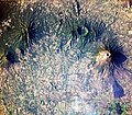
 Volcano in 2013 | |
| Highest point | |
| Elevation | 2,130 m (6,990 ft) |
| Coordinates | 13°25′54″N 88°16′17″W |
| Geography | |
 San Miguel San Miguel Department, El Salvador | |
| Geology | |
| Mountain type | Stratovolcano |
| Last eruption | February 2020[1] |
Eleven years later,[3] on December 29, 2013, San Miguel erupted at 10:30 local time spewing ash and smoke into the sky, and prompted the evacuation of thousands of people living in a 3 km (1.9 mi) radius around the volcano.[4] It was preceded and caused by increased seismic activity beginning at 06:30 local time.[4]
See also
- List of volcanoes in El Salvador
- List of stratovolcanoes
Gallery
 The eruption column on December 29, 2013


References
- "San Miguel". Global Volcanism Program. Smithsonian Institution. Retrieved 27 June 2021.
- Perez, Nemesio (April 2006). "Anomalous Diffuse CO2 Emission Prior to the January 2002 Short-Term Unrest at San Miguel Volcano". Pure and Applied Geophysics. doi:10.1007/s00024-006-0050-1. S2CID 128408097.
- Tadeo, Maria (30 December 2013). "El Salvador begins evacuation after Chaparrastique volcano erupts for the first time in 37 years". The Independent. Retrieved 30 December 2013.
- San Miguel volcano (El Salvador): new eruption. Volcano Discovery. Retrieved 30 December 2013.
External links
 Media related to San Miguel (volcano) at Wikimedia Commons
| Guatemala |  | |
|---|---|---|
| El Salvador | ||
| Nicaragua | ||
| Costa Rica |
| |
| Panama |
| |
Note: volcanoes are ordered from north-west to south-east. | ||
This El Salvador location article is a stub. You can help Wikipedia by expanding it. |
На других языках
[de] Chaparrastique
Der Chaparrastique oder Volcán de San Miguel Bosotlan, ist ein Schichtvulkan in El Salvador. Er befindet sich im Departamento San Miguel etwa 11 Kilometer südwestlich der Stadt San Miguel, einige Kilometer südöstlich der Caldera des älteren Vulkans Chinameca.- [en] San Miguel (volcano)
[es] Volcán de San Miguel
El Volcán de San Miguel, también conocido como Volcán Chaparrastique, está ubicado en el departamento de San Miguel y a 11 kilómetros de la ciudad del mismo nombre en El Salvador. Se levanta aislado de la cordillera de Chinameca. Tiene una altura de 2129 msnm, siendo el tercer volcán más alto del país.[1] Presenta un cráter central de unos 800 metros de diámetro y varios adventicios por los cuales ha expulsado lava quemada. Además, su cono es considerado como el mejor formado del país[2] según él Índice de explosividad volcánica este volcán es nivel 3 de 8 .[fr] San Miguel (volcan)
Le San Miguel, en espagnol Volcán de San Miguel, aussi appelé Chaparrastique, est un volcan du Salvador.[it] San Miguel (vulcano)
Il vulcano San Miguel (noto anche come Chaparrastique) è localizzato nel comune salvadoregno di San Miguel, a circa quindici Km dalla cittadina omonima.[ru] Сан-Мигель (вулкан)
Сан-Мигель (исп. San Miguel), другое название «Чапаррастике» — вулкан, расположенный в восточной части Сальвадора, в одноимённом департаменте Сан-Мигель, в одиннадцати километрах к юго-западу от города Сан-Мигель. Является третьим по высоте вулканом в Сальвадоре, его высота — 2130 м. Диаментр кратера — 800 м.Другой контент может иметь иную лицензию. Перед использованием материалов сайта WikiSort.org внимательно изучите правила лицензирования конкретных элементов наполнения сайта.
WikiSort.org - проект по пересортировке и дополнению контента Википедии