geo.wikisort.org - Mountains
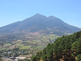
San Vicente (also known as Chichontepec or Las Chiches) is a stratovolcano in central El Salvador. It is located next to the town of San Vicente (hence the name) and is the second highest volcano in El Salvador. In the indigenous language Nahuat, Chichontepec means the mountain of the two breasts,[2] because its double summit resembles a woman's bosom. The volcano has two craters, one located in each summit, although not exactly at the top. Dense vegetation covers both summits. Numerous hot springs and fumaroles are found on the northern and western flanks of the volcano. To the northeast, at 820 metres in a ravine of 180 metres longitude, there are fumaroles—fountains of clear and muddy water or small volcanoes of mud.
| San Vicente | |
|---|---|
| Chichontepec | |
 San Vicente in 1994 | |
| Highest point | |
| Elevation | 2,182 m (7,159 ft)[1] |
| Listing | Breast-shaped hills |
| Coordinates | 13°35′42″N 88°50′13″W[1] |
| Geography | |
| Location | El Salvador |
| Geology | |
| Mountain type | Stratovolcano |
| Last eruption | Unknown[1] |
The last significant eruption occurred more than 1,700 years ago. The volcano may have had a very long history of repeated, and sometimes violent, eruptions, and at least once a large section of the volcano collapsed in a massive landslide.[3]
On August 9, 1995, Aviateca Flight 901 crashed at the volcano, killing all 65 people on board.[4]
See also
- List of volcanoes in El Salvador
- List of stratovolcanoes
- Breast-shaped hill
References
- "San Vicente". Global Volcanism Program. Smithsonian Institution. Retrieved 2021-03-05.
- "San Vicente". Michigan Technological University. Retrieved 2012-05-13.
- J.J. Major, S.P. Schilling, C.R. Pullinger, C.D. Escobar, and M.M. Howell. "Volcano-Hazard Zonation for San Vicente Volcano, El Salvador". USGS. Retrieved 2009-11-13.
{{cite web}}: CS1 maint: uses authors parameter (link) - "Tragedia San Vicente ::: elsalvador.com". Archived from the original on 2010-02-14.
На других языках
[de] Chichontepec
Der Chichontepec, Volcán de San Vicente oder Las Chiches ist der zweithöchste Vulkan in El Salvador. Er befindet sich in den Municipios Guadalupe y Tepetitán im Departamento San Vicente sowie in den Municipios San Juan Nonualco und Zacatecoluca im Departamento La Paz, etwa 60 Kilometer östlich von San Salvador.- [en] San Vicente (volcano)
[es] Volcán de San Vicente
El volcán de San Vicente o Chinchontepec Está ubicado en los municipios de Guadalupe y Tepetitán en el departamento de San Vicente; y Zacatecoluca y San Juan Nonualco en el departamento de la Paz en El Salvador. Se localiza aproximadamente a 60 kilómetros al este de la ciudad capital San Salvador. Es el segundo volcán de más altura de este país. La madrugada del 8 de noviembre de 2009 una fuerte lluvia del huracán Ida que duró cinco horas saturó la tierra en las faldas del volcán de San Vicente, lo que provocó el deslave que acabó con las vidas de 92 personas, aproximadamente, en los municipios de Guadalupe, Tepetitán y Verapaz.[fr] San Vicente (volcan)
Le volcan de San Vicente, ou Chinchontepec en nahuatl (« Montagne des deux seins »), est situé au Salvador, dans les départements de San Vicente et de La Paz, à quelques kilomètres de la ville San Vicente.[it] San Vicente (vulcano)
Il vulcano San Vicente, chiamato in nahuatl (lingua locale) Chinchontepec Montagna dei due seni, è un vulcano esplosivo nel Salvador posto tra i dipartimenti di San Vicente e La Paz, alto 2182 m con la sua vetta più alta e 2083 m con la minore; è attualmente spento.[ru] Сан-Висенте (вулкан)
Сан-Висенте (исп. San Vicente), другие названия «Чичонтепек» и «Лас-Чичес» — вулкан, расположенный в центральной части Сальвадора, на границе департаментов Сан-Висенте и Ла-Пас, в нескольких километрах к юго-западу от города Сан-Висенте. Это второй по высоте вулкан Сальвадора после вулкана Санта-Ана, его высота — 2173 м над уровнем моря.Другой контент может иметь иную лицензию. Перед использованием материалов сайта WikiSort.org внимательно изучите правила лицензирования конкретных элементов наполнения сайта.
WikiSort.org - проект по пересортировке и дополнению контента Википедии

