geo.wikisort.org - Mountains
This is a list of active, dormant, and extinct volcanoes in New Zealand.
Kermadec Arc and Havre Trough
| Name | Elevation | Location | Last eruption | |
|---|---|---|---|---|
| metres | feet | Coordinates | ||
| Brothers Seamount | -1350 | -4400 | 34.875°S 179.075°E | - |
| Clark Seamount | -860 | -2800 | 36.446°S 177.839°E | - |
| Cole (volcano) | - | - | - | - |
| Cotton Volcano | -950 | -3100 | 35.05°S 178.99°E | - |
| Curtis Island | 137 | 449 | 30°32′26.97″S 178°33′25.69″W | - |
| Gamble (volcano) | - | - | - | - |
| Giggenbach (volcano) | -65 | -210 | 30.036°S 178.712°E | - |
| Havre Seamount | -730 | -2360 | 31°07′13″S 179°58′07″W | 2012 |
| Hinepuia (volcano) | - | - | - | - |
| Hinetāpeka (volcano) | - | - | - | - |
| James Healy Seamount | -1150 | -3800 | 34.98°S 179.00°E | 1360 |
| Macauley Island | 238 | 781 | 30.14°S 178.26°W | Holocene |
| Monowai Seamount | -100 | -330 | 25.887°S 177.188°W | 2008 |
| Pūtoto (volcano) | - | - | - | - |
| Rakahore (volcano) | - | - | - | - |
| Raoul Island | 516 | 1693 | 29.16°S 177.55°W | 2006 |
| Rumble I | -1100 | -3610 | 35.5°S 178.9°E | - |
| Rumble II | -880 | -2890 | 35.4°S 178.6°E | - |
| Rumble III | -140 | -459 | 35.745°S 178.478°E | 1986 |
| Rumble IV | -450 | -1476 | 36.13°S 178.05°E | - |
| Rumble V | -1100 | -3610 | 36.139°S 178.197°E | - |
| Silent I[1] | - | - | - | - |
| Silent II[1] | - | - | - | - |
| Tangaroa (volcano) | -600 | -2000 | 36.321°S 178.028°E | - |
| Volcano W | -900 | -3000 | 31.85°S 179.18°E | - |
| Wright (volcano) | -750 | -2500 | 31.5°S 179.2°E | - |
North Island
Taupō Volcanic Zone
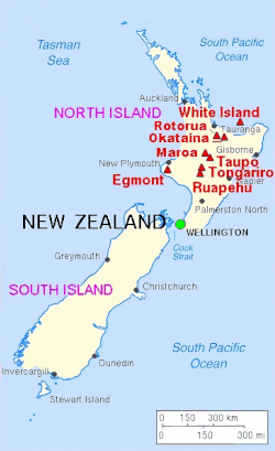
Elsewhere
| Name | Elevation | Location | Last eruption | |
|---|---|---|---|---|
| metres | feet | Coordinates | ||
| Auckland volcanic field | 260 | 853 | 36.90°S 174.87°E | 1421 |
| Bombay Hills | - | - | - | 500,000 years ago |
| Kārewa / Gannet Island | - | - | - | 500,000 years ago |
| Kaikohe-Bay of Islands volcanic field | 388 | 1273 | 35.30°S 173.90°E | 400 ± 300 years |
| Kaitake | - | - | - | 500,000 years ago |
| Kakepuku | 449 | 1473 | 38°04′06″S 175°15′07″E | 1.6 million years ago |
| Karioi | 756 | 2480 | 37.50°S 174.49°E | 2.4 million years ago |
| Little Barrier Island | 722 | 2360 | - | 1.5 million years ago |
| Manukau volcano | 474 | 1555 | - | 16 million years ago |
| Maungatautari | 797 | 2615 | - | - |
| Paritutu and the Sugar Loaf Islands | 153 | - | - | 1.7 million years ago[4] |
| Mount Pirongia | 962 | 3156 | 37°59′28″S 175°05′53″E | 1.6 million years ago |
| Poor Knights Islands | - | - | - | 4 million years ago |
| Pouakai | - | - | - | 240,000 years ago |
| Rangitoto Island (part of the Auckland volcanic field) | 260 | 853 | 36°47′13″S 174°51′29″E | 1350 |
| Mount Taranaki or Mount Egmont | 2518 | 8261 | 39.3°S 174.1°E | 1755 |
| Whangarei volcanic field | 397 | 1302 | 35.75°S 174.27°E | - |
South Island
| Name | Elevation | Location | Last eruption | |
|---|---|---|---|---|
| meters | feet | Coordinates | ||
| Akaroa Volcano | - | - | 43°48′S 172°57′E | Miocene |
| Dunedin Volcano | 680 | 2218 | 45°49′S 170°39′E | c. 10 million years ago [5] |
| Mount Horrible (near Timaru) | - | - | 44°23′S 171°3′E | 2 million years ago [6] |
| Lyttelton Volcano | 919 | 3010 | 43°36′S 172°43′E | Miocene |
Other
| Name | Elevation | Location | Last eruption | |
|---|---|---|---|---|
| meters | feet | Coordinates | ||
| Antipodes Islands | 402 | 1319 | 49.68°S 178.77°E | Holocene |
| Auckland Island | 650 | 1981 | 50.69°S 166.08°E | Miocene[7] |
| Mount Dick (Adams Island)[8] | 705 | 2313 | 50°52′28″S 166°4′55″E | - |
| Pitt Island | 241 | 791 | 44.18°S 176.13°W | Ancient[vague] |
| Solander Islands | 330 | 1080 | 46°34′S 166°53′E | Pleistocene |
Ross Dependency
New Zealand also has de facto administration over Ross Dependency in Antarctica, which contains the following volcanoes:
| Name | Elevation | Location | Last eruption | |
|---|---|---|---|---|
| meters | feet | Coordinates | ||
| Mount Bird (Ross Island) | 1765 | 5791 | 77°16′S 166°45′E | 3.8 million years ago[9] |
| Brown Peak (Sturge Island, Balleny Islands) | 1500 | 5000 | 67°24′S 164°50′E | 2001 |
| Buckle Island (Balleny Islands) | 1239 | 4065 | 66°48′S 163°15′E | 1899 |
| Mount Discovery (Scott Coast) | 2681 | 8796 | 78°22′S 166°01′E | 1.8 million years ago[10] |
| Mount Erebus (Ross Island) | 3794 | 12448 | 77°32′S 167°17′E | 2008 (continuing) |
| Mount Terror (Ross Island) | 3230 | 10597 | 77°31′S 168°32′E | ~ 800,000 years ago |
| Young Island (Balleny Islands) | 1340 | 4396 | 66°25′S 162°27′E | - |
References
- John H. Latter, Edwards F. Lloyd, Ian E.M. Smith, and Simon Nathan. () New Zealand's volcanoes: Kermadec Islands Archived 2010-05-22 at the Wayback Machine. Volcanic Hazards Working Group, Civil Defence Scientific Advisory Committee.
- Nairn, I.A.; Beanland, S. (1989). "Geological setting of the 1987 Edgecumbe earthquake, New Zealand". New Zealand Journal of Geology and Geophysics. 32: 1–13. doi:10.1080/00288306.1989.10421383. Retrieved 30 October 2011.
- "Okataina: Eruptive History". Global Volcanism Program. Smithsonian Institution.
- Price, R. C; R. B. Stewart; J. D. Woodhead; I. E. M. Smith (1999). "Petrogenesis of High-K Arc Magmas: Evidence from Egmont Volcano, North Island, New Zealand". Journal of Petrology. 40 (1): 167–197. doi:10.1093/petrology/40.1.167.
- Bishop, D.G., and Turnbull, I.M. (compilers) (1996). Geology of the Dunedin Area. Lower Hutt, NZ: Institute of Geological & Nuclear Sciences. ISBN 0-478-09521-X.
- Wilson, John (2009). "South Canterbury region – Landscape and geology". Te Ara – the Encyclopedia of New Zealand.
- Adams, C.J (1983). "Age of the volcanoes and granite basements of the Auckland Islands, Southwest Pacific". New Zealand Journal of Geology and Geophysics. 26 (3): 227–237. doi:10.1080/00288306.1983.10422237.
- Auckland Islands Archived 2009-03-20 at archive.today. Polar Conservation Organisation.
- "Mount Bird, Ross Island, Antarctica," http://volcano.oregonstate.edu. Retrieved 10 June 2019.
- "Mount Discovery, Antarctica," http://volcano.oregonstate.edu. Retrieved 10 June 2019.
External links
- New Zealand's Volcanoes at GNS Science
На других языках
[de] Liste von Vulkanen in Neuseeland
Dies ist eine Liste von Vulkanen in Neuseeland, die während des Quartärs mindestens einmal aktiv waren.- [en] List of volcanoes in New Zealand
[fr] Liste des volcans de Nouvelle-Zélande
Cet article recense les volcans de Nouvelle-Zélande.Текст в блоке "Читать" взят с сайта "Википедия" и доступен по лицензии Creative Commons Attribution-ShareAlike; в отдельных случаях могут действовать дополнительные условия.
Другой контент может иметь иную лицензию. Перед использованием материалов сайта WikiSort.org внимательно изучите правила лицензирования конкретных элементов наполнения сайта.
Другой контент может иметь иную лицензию. Перед использованием материалов сайта WikiSort.org внимательно изучите правила лицензирования конкретных элементов наполнения сайта.
2019-2025
WikiSort.org - проект по пересортировке и дополнению контента Википедии
WikiSort.org - проект по пересортировке и дополнению контента Википедии