geo.wikisort.org - Mountains
The Kaikohe-Bay of Islands volcanic field is in the Northland Region of New Zealand. Eruptions have occurred over the last 10 million years. All the cones older than 2 million years have eroded away, leaving plateaus from Okaihau to Kerikeri and north to Whangaroa. In the southern part of the field, around 12 small basaltic scoria cones, and a rhyolite dome erupted in the last 500,000 years around Kaikohe. The field is considered dormant, rather than extinct.[1]
| Kaikohe-Bay of Islands volcanic field | |
|---|---|
 Te Ahuahu, looking from Waimate North | |
| Highest point | |
| Coordinates | 35.348316°S 173.848686°E |
| Geography | |
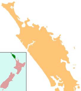 Kaikohe-Bay of Islands volcanic field | |
| Geology | |
| Last eruption | 1300 to 1800 years ago |
List of volcanoes
The volcanoes in the southern part of the field include:[1]
- Kaikohe Hill
- Maungaturoto
- Pouerua
- Putahi
- Tarahi
- Tauanui
- Te Ahuahu
- Te Puke – last erupted 1300 to 1800 years ago[2]
References
- Hayward, Bruce; Smith, Ian (2002). "Field Trip 7: A Taste of Northland Geology" (PDF). In Smith, Vicki; Grenfell, Hugh (eds.). Field Trip Guides, GSNZ Annual Conference "Northland 2002". Geological Society of NZ Miscellaneous Publication 112B. Retrieved 28 March 2012.
- "Kaikohe-Bay of Islands". Global Volcanism Program. Smithsonian Institution. Retrieved 28 March 2021.
This Northland Region-related geography article is a stub. You can help Wikipedia by expanding it. |
Текст в блоке "Читать" взят с сайта "Википедия" и доступен по лицензии Creative Commons Attribution-ShareAlike; в отдельных случаях могут действовать дополнительные условия.
Другой контент может иметь иную лицензию. Перед использованием материалов сайта WikiSort.org внимательно изучите правила лицензирования конкретных элементов наполнения сайта.
Другой контент может иметь иную лицензию. Перед использованием материалов сайта WikiSort.org внимательно изучите правила лицензирования конкретных элементов наполнения сайта.
2019-2025
WikiSort.org - проект по пересортировке и дополнению контента Википедии
WikiSort.org - проект по пересортировке и дополнению контента Википедии