geo.wikisort.org - Mountains
Mount Terror is a large shield volcano that forms the eastern part of Ross Island, Antarctica. It has numerous cinder cones and domes on the flanks of the shield and is mostly under snow and ice. It is the second largest of the four volcanoes that make up Ross Island and is somewhat overshadowed by its neighbour, Mount Erebus, 30 km (19 mi) to the west.[1] Mount Terror was named in 1841 by Sir James Clark Ross for his second ship, HMS Terror.[1] The captain of Terror was Francis Crozier, a close friend of Ross for whom the nearby Cape Crozier is named.
| Mount Terror | |
|---|---|
 Mount Terror (right) and Mount Erebus (left) seen from the Hut Point Peninsula, the southernmost point on Ross Island. | |
| Highest point | |
| Elevation | 3,230 m (10,600 ft)[1] |
| Prominence | 1,728 m (5,669 ft)[2] |
| Listing | Ultra |
| Coordinates | 77°31′S 168°32′E[2] |
| Geography | |
 Mount Terror Ross Island, Antarctica | |
| Geology | |
| Age of rock | 820,000–1.75 million years |
| Mountain type | Shield volcano (extinct) |
| Volcanic belt | McMurdo Volcanic Group |
| Climbing | |
| First ascent | 1959 |
| Easiest route | snow/ice climb |
Geography
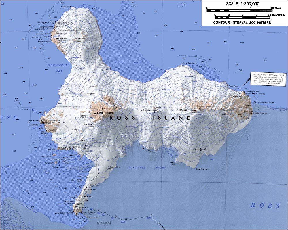
Mount Terror is on the right, Mount Terra Nova is in the middle, and Mount Erebus is on the left. Mount Bird is in the upper left.
The rocks at the summit have not been studied, but rocks from the lower areas range from 0.82 to 1.75 million years old, and Mount Terror shows no signs of more recent volcanic activity.
The first ascent of Mt. Terror was made by a New Zealand party in 1959.
Terror Point (77°41′S 168°13′E), located just below Mt. Terror, is the eastern limit of Fog Bay, 6 km (3.7 mi) WNW of Cape MacKay on Ross Island. The name was first used by members of the British National Antarctic Expedition, 1901–04, and was apparently applied in association with Mt. Terror which overlooks this point from the northeast.[3]
Terror Saddle (77°31′S 168°5′E) is one of three prominent snow saddles on Ross Island, located c.1600 m between Mount Terra Nova and Mount Terror. Named in association with Mount Terror, which rises to 3262 m to the east of this saddle.[4]
Terror Glacier (77°37′S 168°3′E) is a large glacier between Mount Terra Nova and Mount Terror on Ross Island, flowing south into Windless Bight. So named by A.J. Heine of the New Zealand Geological Survey Antarctic Expedition (NZGSAE), 1962–63, because of its association with Mount Terror.[5]
Cultural references
- Mount Terror is the stronghold of Russian anarchist revolutionaries in the 1894 science fiction novel Olga Romanoff by George Griffith.
- Mount Terror and Mount Erebus are mentioned in the 1936 novella At the Mountains of Madness by H.P. Lovecraft.
- Mount Terror is used as a location in the 2004 novel State of Fear by Michael Crichton.
- Mount Terror is referenced in Twenty Thousand Leagues Under The Sea by the narrator Professor Arronax, after they arrive at the South Pole, in reference to two volcanic craters, the Erebus and Terror, in context to an earlier discovery by ‘’James Clark Ross’’.
See also
References
- "Mount Terror". Geographic Names Information System. United States Geological Survey. Retrieved 2016-12-19.
- "Antarctica Ultra-Prominences" Peaklist.org. Retrieved 2012-09-05.
- "Terror Point". Geographic Names Information System. United States Geological Survey. Retrieved 2016-12-19.
- "Terror Saddle". Geographic Names Information System. United States Geological Survey. Retrieved 2021-01-12.
- "Terror Glacier". Geographic Names Information System. United States Geological Survey. Retrieved 2021-01-12.
External links
- "Terror". Global Volcanism Program. Smithsonian Institution. Retrieved 2021-06-24.
Bibliography
- LeMasurier, W. E. (1990). Thomson, J. W. (ed.). Volcanoes of the Antarctic Plate and Southern Oceans. American Geophysical Union. pp. 512 pp. ISBN 0-87590-172-7.
| Authority control |
|
|---|
На других языках
[de] Mount Terror
Der Mount Terror ist ein großer erloschener Schildvulkan, der den östlichen Teil der Ross-Insel bildet. Er ist überwiegend mit Eis und Schnee bedeckt.- [en] Mount Terror (Antarctica)
[es] Monte Terror
El monte Terror es un volcán en escudo situado en la Antártida, localizado en la isla de Ross. Está bañado por las aguas del mar del mismo nombre y dentro de la denominada plataforma o barrera de hielo de Ross, que concentra más del 30% del hielo continental.[fr] Mont Terror
Le mont Terror est une montagne de l'île de Ross en Antarctique, volcan bouclier désormais éteint et voisin du mont Erebus toujours actif[1].[it] Monte Terror
Il monte Terror è una larga caldera vulcanica, la seconda più grande delle tre che formano l'isola di Ross. Deve il suo nome a Sir James Clark Ross che nel 1841 lo battezzò così in onore della sua seconda nave, la HMS Terror. Il monte Terror non mostra attività vulcanica più recente di quella che lo ha formato 1,75 milioni di anni fa.[ru] Террор (вулкан)
Те́ррор[2][3] — щитовой вулкан на востоке острова Росса в Антарктике высотой 3230 м[1][4] (по другим источникам, 3288 м[5]) над уровнем моря. Расположен на расстоянии 30 км от вулкана Эребус. Гора образовалась между 800 000 и 820 000 лет назад. Извержения не известны. В 2000 году зафиксировано крупное землетрясение.Другой контент может иметь иную лицензию. Перед использованием материалов сайта WikiSort.org внимательно изучите правила лицензирования конкретных элементов наполнения сайта.
WikiSort.org - проект по пересортировке и дополнению контента Википедии