geo.wikisort.org - Mountains
Mount Terra Nova is a snow-covered inactive volcanic mountain, 2,130 m (6,990 ft),[1] between Mount Erebus and Mount Terror on Ross Island. It was first mapped by the Discovery expedition in 1901–04, and named for Terra Nova, the relief ship for this expedition and the British Antarctic Expedition, 1910–13.[1]
| Mount Terra Nova | |
|---|---|
 Mount Terra Nova Ross Island, Antarctica | |
| Highest point | |
| Elevation | 2,130 m (6,990 ft)[1] |
| Coordinates | 77°31′S 167°57′E |
| Geography | |
| Location | Ross Island, Antarctica |
| Geology | |
| Age of rock | 820,000-1.75 million years |
| Mountain type | Shield volcano (extinct) |
Terra Nova Saddle (77°31′S 167°37′E) is one of three prominent snow saddles on Ross Island, this one at c. 1,400 m (4,600 ft) between Mount Erebus and Mount Terra Nova. It is named in association with Mount Terra Nova, which rises to 2,130 m (6,990 ft) to the east of this saddle.
Terra Nova Glacier (77°27′S 167°42′E) is a glacier about 5 nautical miles (9 km) long in north–central Ross Island. It flows north from the saddle between Mount Erebus and Mount Terra Nova into Lewis Bay. It is so named for its proximity to Mount Terra Nova.
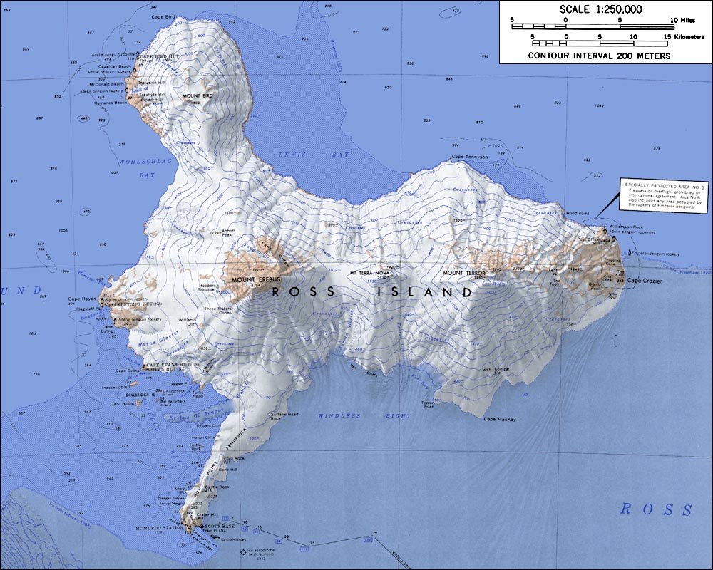
Mount Terra Nova is in the middle.
Mount Terror is in the right.
Mount Erebus is in the lower left.
Mount Bird is in the upper left.
See also
References
- "Terra Nova, Mount". Geographic Names Information System. United States Geological Survey, United States Department of the Interior. Retrieved 2012-08-08.
![]() This article incorporates public domain material from the United States Geological Survey document: "Mount Terra Nova". (content from the Geographic Names Information System)
This article incorporates public domain material from the United States Geological Survey document: "Mount Terra Nova". (content from the Geographic Names Information System)
This Ross Island location article is a stub. You can help Wikipedia by expanding it. |
На других языках
[de] Mount Terra Nova
Mount Terra Nova ist ein 2130 m hoher und erloschener Schichtvulkan im Zentrum der ostantarktischen Ross-Insel. Er liegt zwischen dem westlich gelegenen Mount Erebus und Mount Terror im Osten.- [en] Mount Terra Nova
[fr] Mont Terra Nova
Le mont Terra Nova est une montagne située sur l'île de Ross, en Antarctique. Volcan bouclier désormais éteint, il est voisin du mont Erebus, toujours actif[1].Другой контент может иметь иную лицензию. Перед использованием материалов сайта WikiSort.org внимательно изучите правила лицензирования конкретных элементов наполнения сайта.
WikiSort.org - проект по пересортировке и дополнению контента Википедии