geo.wikisort.org - Mountains
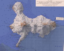
Cinder Hill (77°16′S 166°25′E) is a prominent dissected volcano, 305 metres (1,000 ft) high, consisting of layers of red basalt scoria and cinders and abundant olivine nodules, standing between Harrison Stream and Wilson Stream on the ice-free lower west slopes of Mount Bird, Ross Island. It was mapped and descriptively named by the New Zealand Geological Survey Antarctic Expedition, 1958–59.
References
 This article incorporates public domain material from "Cinder Hill". Geographic Names Information System. United States Geological Survey.
This Ross Island location article is a stub. You can help Wikipedia by expanding it. |
На других языках
[de] Cinder Hill
Der Cinder Hill (deutsch Schlackehügel) ist ein 305 m hoher und zerklüfteter Vulkankegel auf der antarktischen Ross-Insel. Er besteht aus Lagen roter Basaltschlacke durchsetzt mit Olivinknollen und liegt zwischen dem Harrison Stream und dem Wilson Stream an den eisfreien unteren Westhängen des Mount Bird.- [en] Cinder Hill
Текст в блоке "Читать" взят с сайта "Википедия" и доступен по лицензии Creative Commons Attribution-ShareAlike; в отдельных случаях могут действовать дополнительные условия.
Другой контент может иметь иную лицензию. Перед использованием материалов сайта WikiSort.org внимательно изучите правила лицензирования конкретных элементов наполнения сайта.
Другой контент может иметь иную лицензию. Перед использованием материалов сайта WikiSort.org внимательно изучите правила лицензирования конкретных элементов наполнения сайта.
2019-2026
WikiSort.org - проект по пересортировке и дополнению контента Википедии
WikiSort.org - проект по пересортировке и дополнению контента Википедии