geo.wikisort.org - Island
Ross Island is an island formed by four volcanoes in the Ross Sea near the continent of Antarctica, off the coast of Victoria Land in McMurdo Sound. Ross Island lies within the boundaries of Ross Dependency, an area of Antarctica claimed by New Zealand.
 Map of Ross Island | |
 Ross Island | |
| Geography | |
|---|---|
| Location | Antarctica |
| Coordinates | 77°30′S 168°00′E |
| Archipelago | Ross Archipelago |
| Area | 2,460 km2 (950 sq mi) |
| Highest elevation | 3,794 m (12448 ft) |
| Highest point | Mount Erebus |
| Administration | |
| Administered under the Antarctic Treaty System | |
| Demographics | |
| Population | At least 100 |
History
Discovery
Sir James Ross discovered it in 1840, and it was later named in honour of him by Robert F. Scott.
Ross Island was the base for many of the early expeditions to Antarctica. It is the southernmost island reachable by sea. Huts built by Scott's and Shackleton's expeditions are still standing on the island, preserved as historical sites.
Today Ross Island is home to New Zealand's Scott Base, and the largest Antarctic settlement, the U.S. Antarctic Program's McMurdo Station. Greenpeace established World Park Base on the island and ran it for five years, from 1987 to 1992.
Geography
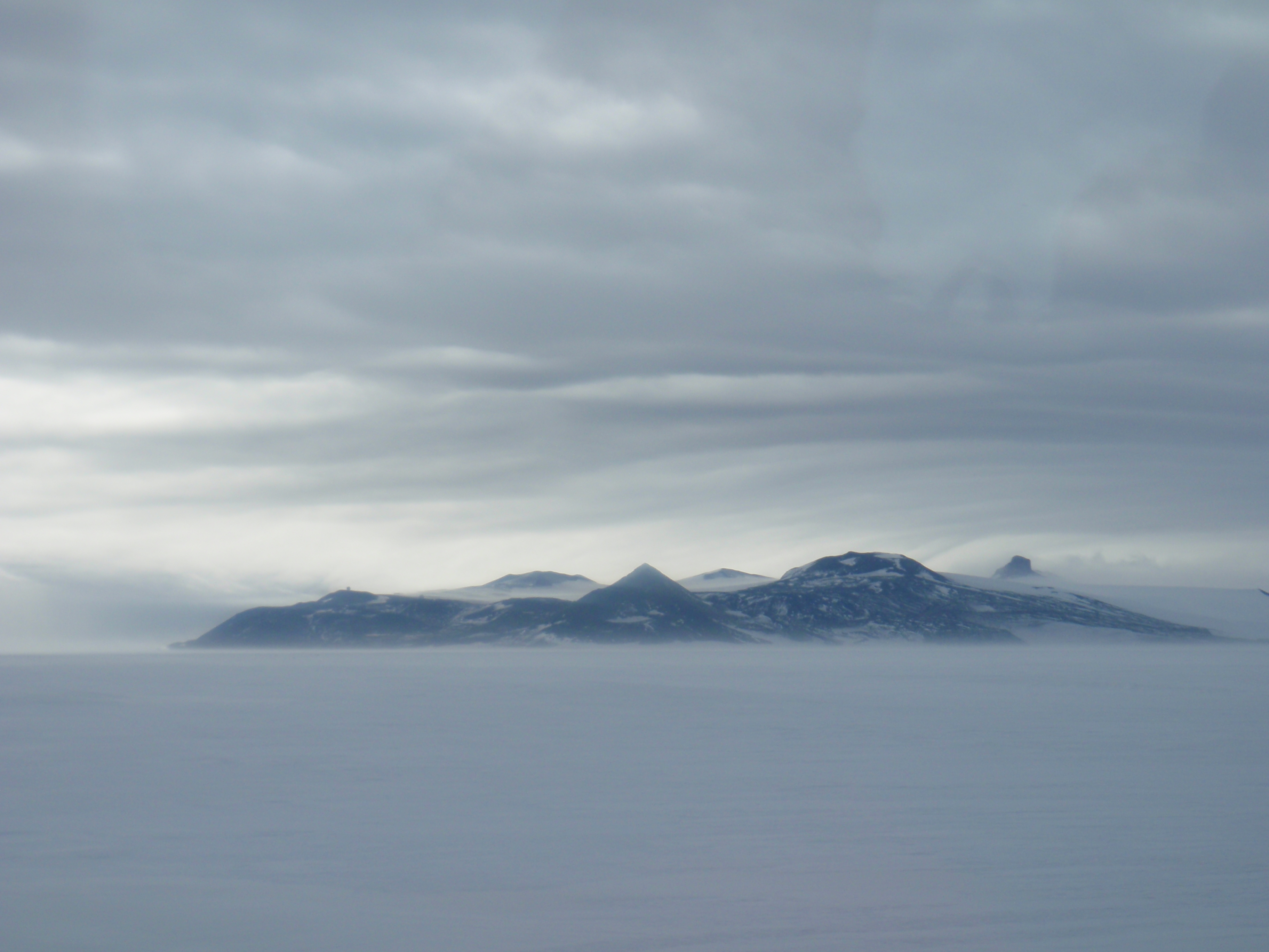
Because of the persistent presence of the ice sheet, the island is sometimes taken to be part of the Antarctic mainland. Its area is 2,460 square kilometres (950 sq mi); only a small portion of the island is free of ice and snow.
The planet's southernmost active volcano, Erebus (3,794 m or 12,448 ft), as well as the dormant volcano Terror (3,230 m or 10,597 ft), are situated on the island. They were named by Captain James Ross after his ships HMS Erebus and HMS Terror. The third highest elevation is Mount Bird, with Shell Glacier and Endeavour Piedmont Glacier on its slopes. Abbott Peak stands between Mount Erebus and Mount Bird. Gamble Cone and Kyle Cone stand in the east of the island.[1] Beeby Peak is 4.4 kilometres (2+3⁄8 nautical miles) east-northeast of the summit of Mount Bird.
Despite its relatively small size, Ross Island is the world's 6th highest island and the highest island in Antarctica. It has the highest average elevation of any island.[citation needed]
Landmarks
Many features on or near Ross Island have been charted and named by various survey and exploration groups.
Mount Erebus is the island's most prominent landmark. Hut Point Peninsula, the site of McMurdo Station (US) and Scott Base (New Zealand), projects southwest from its lower slopes. Barne Glacier projects off its western slopes. To the north of Mount Terror are the Kienle Nunataks.
The far eastern point of the island is called Cape Crozier. On the west side of the island is rocky Cape Evans, which forms the north side of Erebus Bay.
See also
- Composite Antarctic Gazetteer
- Erebus hotspot
- Erebus Ice Tongue
- List of Antarctic and sub-Antarctic islands
- List of Antarctic islands south of 60° S
- List of islands of New Zealand
- McMurdo Sound
- New Zealand Subantarctic Islands
- Ross Sea
- Ross Bank
- SCAR
- Territorial claims in Antarctica
- Air New Zealand Flight 901
- Pakaru Icefalls
References
- LeMasurier, W. E.; Thomson, J. W., eds. (1990). Volcanoes of the Antarctic Plate and Southern Oceans. American Geophysical Union. p. 512. ISBN 0-87590-172-7.
External links
| Wikimedia Commons has media related to Ross Island. |
- Coastal-change and Glaciological Map of the Ross Island Area, Antarctica, 1962-2005 United States Geological Survey
Authority control | |
|---|---|
| General |
|
| National libraries | |
| Other | |
На других языках
[de] Ross-Insel
Die Ross-Insel ist eine 2460 km² große vulkanische Insel im Rossmeer der Antarktis, nahe der Küste von Viktorialand. Sir James Clark Ross entdeckte sie 1841; Robert F. Scott benannte diese Insel nach ihm. Ross benannte mit Mount Terror und Mount Erebus zwei der drei Vulkane auf der Insel nach seinen Schiffen HMS Terror und HMS Erebus. Der dritte Vulkan heißt Mount Bird und befindet sich auf der nördlichen Halbinsel, die am Kap Bird endet. Nur Mount Erebus ist heute noch aktiv.- [en] Ross Island
[fr] Île de Ross
L'île de Ross est une île volcanique de la mer de Ross, dans l’océan Pacifique Sud. Elle fait face à la chaîne du Prince-Albert, située entre la Terre Victoria et la côte Hillary (en), dans la chaîne Transantarctique.[it] Isola di Ross
L'isola di Ross è un'isola vulcanica situata nel mare di Ross in Antartide, al largo della Terra della regina Victoria.[ru] Остров Росса
Остров Росса — остров вулканического происхождения в одноимённом море. Размеры примерно 70 на 72 км. Площадь 2460 км². Практически полностью покрыт снегом и льдом. Наивысшая точка — вулкан Эребус (3795 м), один из двух активных вулканов Антарктики (второй — Десепшен). Ещё одной главенствующей вершиной острова является потухший вулкан Террор (3230 м)[1][2]. От материковой части Антарктиды отделён проливом Мак-Мердо, часть которого скрыта шельфовым ледником Росса[1][3]. В связи с этим иногда рассматривается как полуостров (а пролив Мак-Мердо — как залив).Другой контент может иметь иную лицензию. Перед использованием материалов сайта WikiSort.org внимательно изучите правила лицензирования конкретных элементов наполнения сайта.
WikiSort.org - проект по пересортировке и дополнению контента Википедии