geo.wikisort.org - Isola
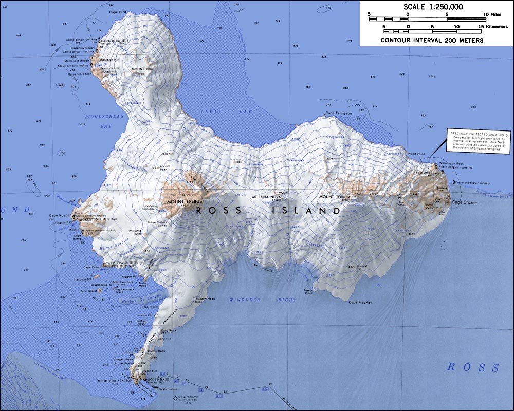
L'isola di Ross è un'isola vulcanica situata nel mare di Ross in Antartide, al largo della Terra della regina Victoria.
| Isola di Ross | |
|---|---|
| Geografia fisica | |
| Localizzazione | Oceano Antartico |
| Coordinate | 77°40′S 168°00′E |
| Superficie | 2.460 km² |
| Altitudine massima | Monte Erebus, 3.794 m s.l.m. |
| Geografia politica | |
| Sovranità | |
| Amministrazione | Secondo il Trattato Antartico. |
| Rivendicazione | |
| Demografia | |
| Abitanti | fra 250 e 1258 |
| Cartografia | |
 | |
 Isola di Ross | |
| voci di isole antartiche presenti su Wikipedia | |
Fu scoperta nel 1841 da sir James Clark Ross. L'isola fu successivamente chiamata così da Robert Falcon Scott.
Sull'isola si trovano i due vulcani Terror (3230 m) e Erebus (3794 m) così chiamati traendo spunto dalla due navi che componevano la spedizione di Ross: HMS Terror e HMS Erebus.
L'isola di Ross è stata la base per molte delle prime spedizioni fatte in Antartide. È l'isola più meridionale raggiungibile via mare.
Le capanne costruite dalle spedizioni di Shackleton e Scott si trovano ancora sull'isola e sono tutelate come luoghi storici.
Bibliografia
- (EN) W. E. LeMasurier e J. W. Thomson (a cura di), Volcanoes of the Antarctic Plate and Southern Oceans, American Geophysical Union, 1990, ISBN 0-87590-172-7.
Voci correlate
- Monte Erebus
- Capo Evans
- Volo Air New Zealand 901
- Punto caldo Erebus
Altri progetti
 Wikimedia Commons contiene immagini o altri file su isola di Ross
Collegamenti esterni
- (EN) Isola di Ross, su Enciclopedia Britannica, Encyclopædia Britannica, Inc.
- (EN) Isola di Ross, su Geographic Names Information System per l'Antartico, USGS.
| Controllo di autorità | VIAF (EN) 315146840 · LCCN (EN) sh92005877 |
|---|
На других языках
[de] Ross-Insel
Die Ross-Insel ist eine 2460 km² große vulkanische Insel im Rossmeer der Antarktis, nahe der Küste von Viktorialand. Sir James Clark Ross entdeckte sie 1841; Robert F. Scott benannte diese Insel nach ihm. Ross benannte mit Mount Terror und Mount Erebus zwei der drei Vulkane auf der Insel nach seinen Schiffen HMS Terror und HMS Erebus. Der dritte Vulkan heißt Mount Bird und befindet sich auf der nördlichen Halbinsel, die am Kap Bird endet. Nur Mount Erebus ist heute noch aktiv.[en] Ross Island
Ross Island is an island formed by four volcanoes in the Ross Sea near the continent of Antarctica, off the coast of Victoria Land in McMurdo Sound. Ross Island lies within the boundaries of Ross Dependency, an area of Antarctica claimed by New Zealand.[es] Isla de Ross
La isla de Ross está formada fundamentalmente por tres montañas de origen volcánico en el mar de Ross de la Antártida, frente a la costa de la Tierra de Victoria en el estrecho de McMurdo. La superficie de la isla es de 2460 km². Solo una pequeña parte de la isla está libre de hielo y nieve.[fr] Île de Ross
L'île de Ross est une île volcanique de la mer de Ross, dans l’océan Pacifique Sud. Elle fait face à la chaîne du Prince-Albert, située entre la Terre Victoria et la côte Hillary (en), dans la chaîne Transantarctique.- [it] Isola di Ross
[ru] Остров Росса
Остров Росса — остров вулканического происхождения в одноимённом море. Размеры примерно 70 на 72 км. Площадь 2460 км². Практически полностью покрыт снегом и льдом. Наивысшая точка — вулкан Эребус (3795 м), один из двух активных вулканов Антарктики (второй — Десепшен). Ещё одной главенствующей вершиной острова является потухший вулкан Террор (3230 м)[1][2]. От материковой части Антарктиды отделён проливом Мак-Мердо, часть которого скрыта шельфовым ледником Росса[1][3]. В связи с этим иногда рассматривается как полуостров (а пролив Мак-Мердо — как залив).Текст в блоке "Читать" взят с сайта "Википедия" и доступен по лицензии Creative Commons Attribution-ShareAlike; в отдельных случаях могут действовать дополнительные условия.
Другой контент может иметь иную лицензию. Перед использованием материалов сайта WikiSort.org внимательно изучите правила лицензирования конкретных элементов наполнения сайта.
Другой контент может иметь иную лицензию. Перед использованием материалов сайта WikiSort.org внимательно изучите правила лицензирования конкретных элементов наполнения сайта.
2019-2026
WikiSort.org - проект по пересортировке и дополнению контента Википедии
WikiSort.org - проект по пересортировке и дополнению контента Википедии