geo.wikisort.org - Mountains
Jabal Haraz (Arabic: جَبَل حَرَاز, romanized: Jabal Ḥarāz) is a mountainous region of Yemen, between Sanaa and Al-Hudaydah, which is considered to be within the Sarat range.[1] In the 11th century, it was the stronghold of the Sulaihid dynasty, many of whose buildings still survive today.[2] It includes Jabal An-Nabi Shu'ayb, the highest mountain in Yemen and the Arabian Peninsula.[3]
| Jabal Haraz | |
|---|---|
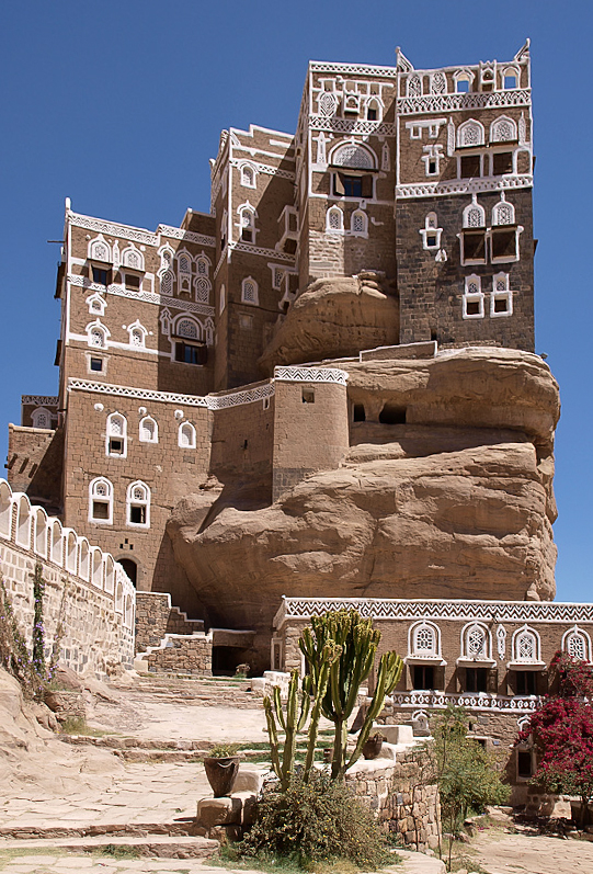
 A building with terraces overlooks the side of one of the Haraz mountains | |
| Highest point | |
| Elevation | 3,000 m (9,800 ft) |
| Coordinates | |
| Naming | |
| Native name | جَبَل حَرَاز (Arabic) |
| Geography | |
 Jabal Haraz  Jabal Haraz  Jabal Haraz | |
| Country | |
| Region | Asia |
History and location
Because of its location between the Tihamah coastal plain and Sanaa, this mountainous area has always been strategically important. A caravan stopping point during the Himyarite Kingdom, the Haraz was later the stronghold of the Sulayhid dynasty, which was established in Yemen in 1037. Then and subsequently the population have been Ism'aili Shi'ite Muslims.
Haraz is as famous for its fortified villages which cling to nearly inaccessible rocky peaks. Their imposing architecture meets two needs: defending the villagers, while leaving plenty of space for crops. Each town is built like a castle; the houses, themselves, form the wall, equipped with one or two easily defensible doors. Constructed from sandstone and basalt, the buildings are integrated into the landscape and it is difficult to tell where the rock and the village begins or ends. The mountain is divided into terraces of a few acres or more, separated by walls sometimes several meters high. On these terraced fields grow alfalfa for livestock, millet, lentils, large areas for coffee and qat. It is one of the main growing areas of Mocha coffee beans.
Within a day's journey are Bani Murrah and other villages located on the ridge overlooking Manakhah. Manakhah is the heart of mountain range, a large town whose market attracts villagers from the entire neighbourhood. Al Hajjara, to the west of Manakhah, is a walled village whose citadel was founded in the 12th century by the Sulayhids. From there, other villages are accessible, such as Bayt al-Qamus and Bayt Shimran. The village of Hutaib is built on a platform of red sandstone, facing a view of terraced hills which host a score of villages. Here also is the mausoleum of the third Yemeni Da'i al-Mutlaq Hatim ibn Ibrahim. Bohras from India, Sri Lanka, Madagascar and other countries gather here.[citation needed]
World Heritage Status
This area was added to the UNESCO World Heritage Tentative List on July 8, 2002, in the mixed (cultural and natural) category, as a site that has "outstanding universal value".[2]
Gallery
 Jabal An-Nabi Shu'ayb, the highest mountain in the Arabian Peninsula, as viewed from Kawkaban, Al Mahwit Governorate
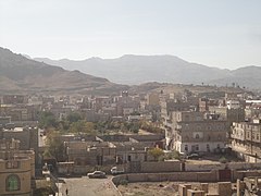 Jabal An-Nabi Shu'ayb is behind the mountain in the background, facing west of southern Sanaa City
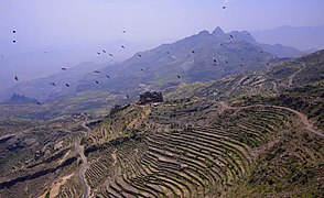 Jabal Haraz terraces
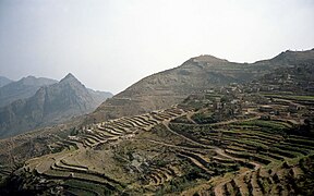 Manakhah
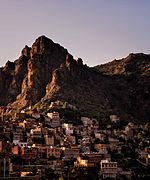 Buildings at the base of a mountain
 Fortified settlement amid the mountains


See also
- Ad Dahrah, located in the Haraz, the stronghold of the Sulaihid dynasty, many of whose buildings still survive to this day
- Geology of Yemen
- Hajhir Mountains
References
- Cook, John; Farmer, G. Thomas (2013-01-12). "VI: Land and Its Climates". Climate Change Science: A Modern Synthesis. Vol. 1 – The Physical Climate. Springer Science & Business Media. p. 334. ISBN 978-9-4007-5757-8.
- "Jabal Haraz". UNESCO World Heritage Centre. 2002-07-08. Retrieved 2009-03-24.
- McLaughlin, Daniel (2008). "1: Background". Yemen. Bradt Travel Guides. p. 3. ISBN 978-1-8416-2212-5.
External links
- Architecture Revived: Architectural Beauty out of Poverty, Jabal Haraz Yemen
- Med-O-Med: Cultural landscapes: Jabal Bura and Jabal Haraz, Yemen
- Jabal Haraz (YouTube)
- Yemen - Haraz Mountains
- Yemen 2008 Jebel Haraz
| World Heritage Sites |
| |||||||||||||
|---|---|---|---|---|---|---|---|---|---|---|---|---|---|---|
| ||||||||||||||
Hills and mountains on the Arabian Peninsula | ||
|---|---|---|

 | ||
Note: Mountains are sorted in alphabetical order, unless where it concerns ranges. The highest confirmed mountains in each country are indicated with 'HP', and those with the highest peak are indicated with 'HP', bearing in mind that in the UAE, the highest mountain and the mountain with the highest peak are different. Outcrops are indicated with 'OC', and outliers with 'OL', and anticlines with 'AC'. Volcanoes are indicated with 'V', volcanic craters with 'VC', lava fields with 'LF', and volcanic fields with 'VF'.
Other notes:
| ||


На других языках
- [en] Jabal Haraz
[ru] Джебель-Хараз
Джебель-Хараз (араб. جبل حراز) — гряда гор Йемена между Саной и Ходейдой. Горы Хараз расположены в 90 км на запад-юго-запад от Саны. В XI веке это была твердыня династии Сулиахидов, многие здания которой целы до сих пор.Другой контент может иметь иную лицензию. Перед использованием материалов сайта WikiSort.org внимательно изучите правила лицензирования конкретных элементов наполнения сайта.
WikiSort.org - проект по пересортировке и дополнению контента Википедии