geo.wikisort.org - Mountains
The Hajar Mountains (Arabic: جِبَال ٱلْحَجَر, romanized: Jibāl al-Ḥajar, The Rocky Mountains[3][4] or The Stone Mountains) in northeastern Oman and also the eastern United Arab Emirates are the highest mountain range in the eastern Arabian peninsula. Also known as "Oman Mountains",[1][2] they separate the low coastal plain of Oman from the high desert plateau, and lie 50–100 km (31–62 mi) inland from the Gulf of Oman.
| Hajar Mountains | |
|---|---|
| Oman Mountains[1][2] Rocky Mountains[3][4] Stone Mountains, Asabon Mountains | |
 | |
| Highest point | |
| Peak | Jebel Shams, Oman |
| Elevation | 3,009 m (9,872 ft) |
| Naming | |
| Native name | جِبَال ٱلْحَجَر (Arabic) |
| Geography | |
   | |
| Countries | |
| Region | Asia |
| Range coordinates | 23.3°N 57.1°E |
Al (اَلْ) means "the", and Ḥajar (حَجَر) means "stone" or "rock". So al-Ḥajar (اَلْحَجَر) is named as "the stone" or "the rock".
Geology

Orography and tectonic setting
The Hajar Mountains extend for 700 kilometres (430 miles) through the UAE and Oman.[5] They are located on the north-east corner of the Arabian Plate, reaching from the Musandam Peninsula through to the east coast of Oman. The range is about 100 km (62 mi) wide, with Jabal Shams being the highest peak at 3,009 m (9,872 ft) in the central region of the mountains.[6][7]
Currently, the Arabian Plate is moving north relative to the Eurasian Plate at 2–3 cm (0.79–1.18 in) per year.[8][9] Continental collision is occurring at the Zagros fold and thrust belt west of the Musandam Peninsula.[10][11] This collisional plate boundary transitions into a subduction zone, towards the east. Here, oceanic crust of the Arabian Plate is subducted northwards beneath Eurasia, called the Makran subduction zone.[12]
Lithology
The geology of the Hajar can be grouped into four major tectonostratigraphic groups. Group one are the pre-Permian basement rocks, a sedimentary sequence of clastics, carbonates and evaporites. Group two are a middle Permian to Late Cretaceous sequence of continental shelf carbonates, which were deposited unconformably above the basement. Group three are a series of nappes (allochthonous rocks) that were transported from the northeast to the southwest horizontally for more than 300 km (190 mi). This was a major tectonic event during the late Cretaceous. This process is called obduction, where Permian to middle Cretaceous continental slope-rise (shallow to deep marine) sedimentary rocks and late Cretaceous oceanic crust (Semail ophiolite) were thrust (obducted) above the rocks from groups one and two. Lastly, group four are late Cretaceous to Miocene shallow marine and terrestrial sedimentary rocks that were deposited on top of all three previous groups.[13][14][15][16][17][18][19]
Structures
The high topography is around two major culminations: Jabal Akhdar and Saih Hatat, which are large scale anticlines.[20] The Saih Hatat culmination contains eclogite in the northeast at As Sifah.[21] These rocks were subducted to about 80 km (50 mi) depth into the mantle, and then exhumed back to the surface.[18] This exhumation event created possibly the largest megasheath fold on Earth, the Wadi Mayh megasheath fold.[22] The common view is that these eclogites were originally basic volcanic rocks within the leading edge of the continental crust of the Arabian Plate. This leading edge was then subducted by a NE-dipping subduction zone.[23][24] However, some geologists have interpreted that these eclogites were subducted through a SW-dipping subduction zone.[25]
The two culminations are separated by the Semail Gap. This is a prominent linear structure, trending NNE—SSW. However, it is still debated as to what this structure is. Different geologists claim that it is a left-lateral (sinistral) strike-slip fault,[26] a normal fault,[20] a lateral ramp,[27] a monocline due to a blind thrust,[14] or a fault with multiple phases of deformation.[28]
Modern topography
The late Cretaceous obduction event created the proto-Hajar Mountains. However, this topography subsided and shallow marine sedimentation covered the region, beginning in the Paleocene.[17][29] Paleocene to Eocene sedimentary rocks are found at 2,200 m (7,200 ft) above sea level within the Hajar,[27] and are folded. This indicates that the present day topography formed after the late Eocene. The exact timing is debated, and various interpretations indicate the topography formed anywhere between the late Eocene through to the Miocene.[20][29][27][30][31]
The driving forces that formed the Hajar is also debated. Many geologists relate the Zagros Collision as the reason for the uplift forming the mountains,[17][29][32][33] as currently the Musandam Peninsula (northwest corner of the mountain range) is uplifting due to this collision. However, Jabal Shams, the highest peak of the central mountains is over 300 km (190 mi) away from this zone. In addition, there is no major seismicity within the central mountains,[34] indicating that the mountains are not currently deforming, even though the Zagros collision is.[27] This indicates that the uplift that created the present day topography occurred in the past, possibly before the initiation of the Zagros collision, by a mechanism that is not fully understood.
Geoconservation

Oman's geological record is extremely valuable to geologists, and needs to be preserved.[35] It contains the most complete ophiolite on Earth, of which it is most famous for among geologists. The ophiolite sequence has spectacular pillow basalt (Geotimes pillow lava), as well as exposures of the fossil crust-mantle boundary (moho). Generally, ophiolites are obducted prior to continental collision, which highly deforms the structure of the original oceanic crust. However, because continental collision has not occurred in the Hajar, the Semail ophiolite is still intact. Oman also has one of the best exposed mega-sheath folds ever discovered, the Wadi Mayh sheath fold.[22] Additionally, the relatively small outcrop of eclogite is important. Eclogite is rare on the Earths surface, as it is a rock that forms at high pressures deep within the crust or mantle. Geologists can learn about what is occurring in the Earths interior and tectonic processes from these rocks. There are also various fossil localities in Oman that need to be protected. There is concern in the geological community that with the development of infrastructure these rocks that contain a great deal of information will be excavated and destroyed.[35]
Geography
Central Hajar

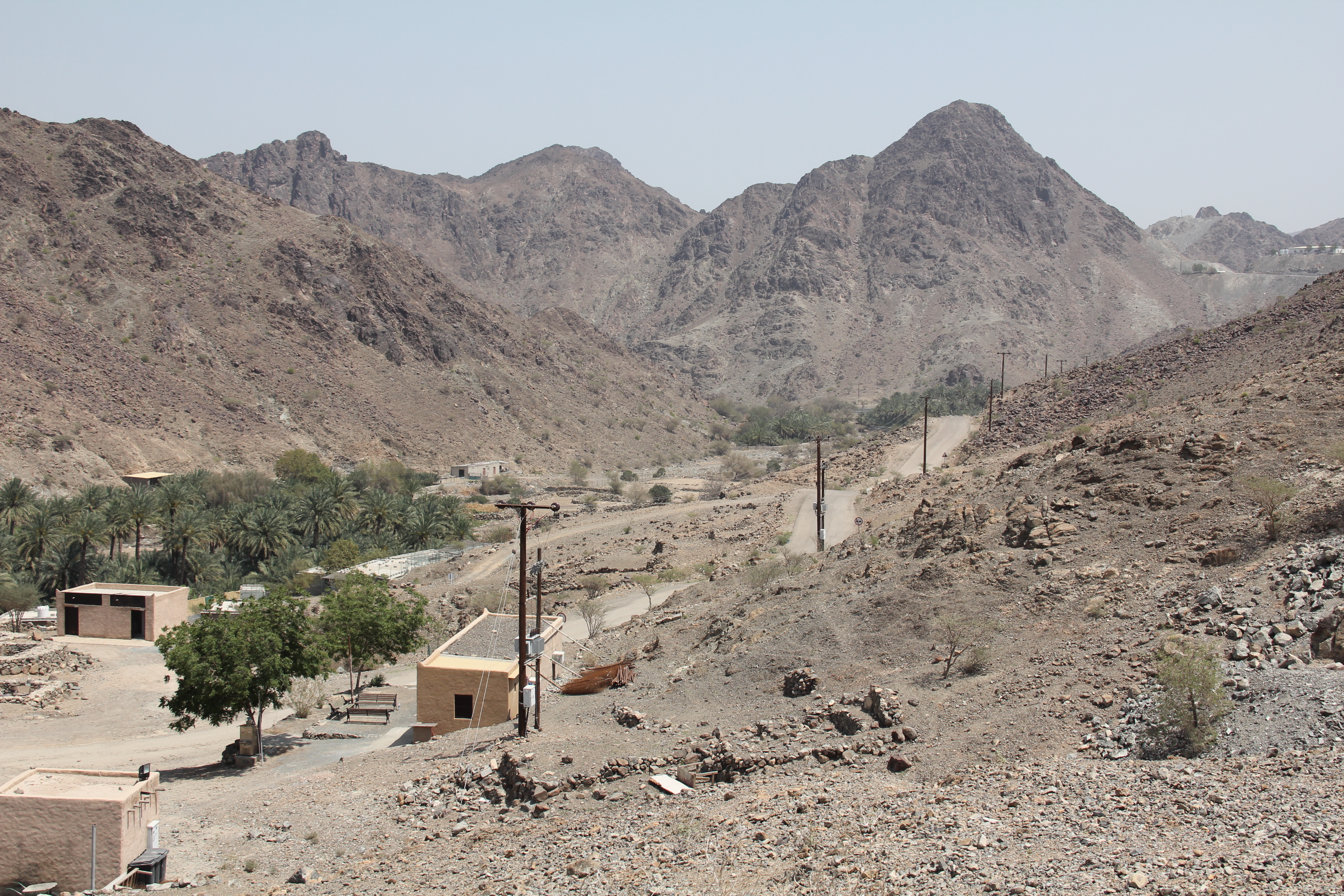
The central section of the Hajar is the highest and wildest terrain in the country. Jabal Shams is the highest of the range,[36] followed by Jebel Akhdar. The latter[37] and the smaller Jebel Nakhl range are bounded on the east by the low Sama'il Valley (which leads northeast to Muscat).[38]
Eastern Hajar
East of Samail are the Eastern Hajar (Arabic: ٱلْحَجَر ٱلشَّرْقِي, romanized: Al-Ḥajar Ash-Sharqī), which run east (much closer to the coast) to the port city of Sur,[39] almost at the easternmost point of Oman.
Western Hajar

The mountains to the west of Sama'il Valley, particularly those in Musandam Peninsula and the UAE,[40] are known as the Western Hajar (Arabic: ٱلْحَجَر ٱلْغَرْبِي, romanized: Al-Ḥajar Al-Gharbī),[41] also known as the "Oman proper". Since Jabal Akhdar and mountains in its vicinity are west of the valley, they may be regarded as Western Hajar.[1][40]
Outlier(s)
In the region of Tawam,[42] which includes the adjacent settlements of Al-Buraimi and Al Ain on the border of Oman and the UAE Emirate of Abu Dhabi, lies Jebel Hafeet (1,100–1,400 m (3,600–4,600 ft)),[43][44][45][46] which can be considered an outlier of the Hajar. Due to its proximity to the main Hajar range,[44] it may be treated as being part of the range, sensu lato.[47] This mountain has ridges which stretch northwards to the city of Al Ain.[48][49][50][51]
Ru'us al-Jibal

The northernmost mountains of the Hajar range are found on the Musandam Peninsula. For this reason, the phrase Ru'us al-Jibal ("Heads of the Mountains") is applied to them, or the peninsula itself. Despite being physically part of the western Hajar, they differ in geology and hydrology to the rest of the range.[1][40] The highest point in the UAE is located at Jebel Jais near Ras Al Khaimah, which measures 1,934 m (6,345 ft) from sea level,[43] but since the summit is on the Omani side, Jabal Yibir, measuring over 1,500 m (0.93 mi), has the highest peak in the UAE.[52][53]
Shumayliyyah
The mountains bordering the Shamailiyyah (شَمَيْلِيَّة) coast on the Gulf of Oman, forming parts of the northern UAE Emirates of Sharjah, Ras Al-Khaimah and Fujairah,[40] may also be called the Shumayliyyah (شُمَيْلِيَّة).[54][55] In this region is Jebel Al-Ḥeben (جَبَل ٱلْحبن; 25°7′33″N 56°9′33″E).[56][57]
Flora and fauna

The mountains are rich in plant life compared to most of Arabia, including a number of endemic species. The vegetation changes with altitude, the mountains are covered with shrubland at lower elevations, growing richer and then becoming woodland, including wild olive and fig trees between 3,630 and 8,250 ft (1,110 and 2,510 metres), and then higher still there are junipers. Fruit trees such as pomegranate and apricot are grown in the cooler valleys and in places there are rocky outcrops with little vegetation. The flora shows similarities with mountain areas of nearby Iran, as well as with areas along the Red Sea in the Horn of Africa. For example, the tree Ceratonia oreothauma is found here and also in Somalia.[58]
A number of birds are found in the mountains including Egyptian and lappet-faced vultures (Torgos tracheliotus). Mammals include mountain gazelles (Gazella gazella) and the Arabian tahr (Arabitragus jayakari).[59][60] Other endemic species include a number of geckos and lizards: Asaccus montanus, Asaccus platyrhynchus and a subspecies of Wadi Kharrar rock gecko (Pristurus gallagheri) are found only in Oman while Musandam leaf-toed gecko (Asaccus caudivolvulus), Gallagher's leaf-toed gecko (Asaccus gallagheri), Oman rock gecko (Pristurus celerrimus), Jayakar lizard (Omanosaura jayakari) and Oman blue-tailed lizard (Omanosaura cyanura) are found only in the Hajar. The endangered Arabian leopard (Panthera pardus nimr) had been recorded here,[54] particularly in the area of Khasab in northern part of the Musandam.[61][62]
Like the Ru'us al-Jibal,[63] the area of Jebel Hafeet is noted for hosting rare flora and fauna.[64][65] For example, in February 2019, an Arabian caracal was sighted here,[66][67][68] and in March, a Blanford's fox,[69][70] which has also been reported in the mountains of Ras Al-Khaimah.[71]
Threats and preservation
The Hajar are extensively grazed by domestic goats, camels and donkeys and the landscape has been cleared in parts for urban areas and for mining, which has damaged both vegetation and water supplies and uprooted traditional rural land management behaviours. Poaching of wildlife is another issue. The Oman government has created the Wadi Sareen Reserve and an area of Jebel Qahwan-Jebal Sebtah in the Eastern Hajar, for the protection of Arabian tahr and mountain gazelle. For visitors, there is a road into the mountains from the town of Birkat al-Mawz (on the road to Nizwa from Muscat) and a walking route through Wadi al-Muaydin to the Saiq Plateau.[citation needed]
Trekking and hiking
There are 11 marked trails/routes of varying intensity (between Grade 1 to 3) and duration (between 1.5 hours to 18 hours) published by Ministry of Tourism, Oman along the Hajar range.[72] Some areas are inaccessible, and requires special equipment, as shown in a Steve Backshall TV documentary.[73]
See also
- Gabal Hagar El Zarqa
- Hafit period
- Hatta Heritage Village
- List of tourist attractions in the United Arab Emirates
- Hills of Masirah Island
- Ras al-Jinz
References
- Allen, Calvin H. Jr. (2016-02-05). "1: Land and People". Oman: the Modernization of the Sultanate. Abingdon, New York: Routledge. pp. 1–8. ISBN 978-1-3172-9164-0.
- Geukens, F. (1966). Bowers, S. D. (ed.). United States Geological Survey Professional Paper. Washington, D.C.: U.S. Government Printing Office.
- Al-Yahyai, Sultan; Charabi, Yassine; Al-Sarmi, Said; Al-Maskari, Juma (2017-05-09). "3: Scenarios Based Climate Projection for Oman's Water Resources". In Abdalla, Omar; Kacimov, Anvar; Chen, Mingjie; Al-Maktoumi, Ali; Al-Hosni, Talal; Clark, Ian (eds.). Water Resources in Arid Areas: The Way Forward. Springer. p. 49. ISBN 978-3-3195-1856-5.
- Megdiche-Kharrat, Fairouz; Ragala, Rachid; Moussa, Mohamed (2016-11-25). "12: The Aqueducts of the Sultanate of Oman: Sustainable Water-Supplying Irrigating Oases Cities". In Angelakis, Andreas N.; Chiotis, Eustathios; Eslamian, Saeid; Weingartner, Herbert (eds.). Underground Aqueducts Handbook. CRC Press. p. 206. ISBN 978-1-4987-4831-5.
- Searle, M. P.; Cooper, D. J. W. (1986). "Structure of the Hawasina Window culmination, central Oman Mountains". Earth and Environmental Science Transactions of the Royal Society of Edinburgh. 77 (2): 143–156. doi:10.1017/S0263593300010798. ISSN 1473-7116.
- Breton, Jean-Paul; Béchennec, François; Métour, Joël Le; Moen-Maurel, Laure; Razin, Philippe (2004-04-01). "Eoalpine (Cretaceous) evolution of the Oman Tethyan continental margin: insights from a structural field study in Jabal Akhdar (Oman Mountains)". GeoArabia. 9 (2): 41–58. doi:10.2113/geoarabia090241. ISSN 1025-6059. S2CID 197865202.
- Kusky, Timothy; Robinson, Cordula; El-Baz, Farouk (September 2005). "Tertiary–Quaternary faulting and uplift in the northern Oman Hajar Mountains". Journal of the Geological Society. 162 (5): 871–888. Bibcode:2005JGSoc.162..871K. doi:10.1144/0016-764904-122. ISSN 0016-7649. S2CID 59467623.
- ArRajehi, Abdullah; McClusky, Simon; Reilinger, Robert; Daoud, Mohamed; Alchalbi, Abdulmutaleb; Ergintav, Semih; Gomez, Francisco; Sholan, Jamal; Bou‐Rabee, Firyal; Ogubazghi, Ghebrebrhan; Haileab, Biniam (2010). "Geodetic constraints on present-day motion of the Arabian Plate: Implications for Red Sea and Gulf of Aden rifting". Tectonics. 29 (3): TC3011. Bibcode:2010Tecto..29.3011A. doi:10.1029/2009TC002482. ISSN 1944-9194. S2CID 55625864.
- DeMets, Charles; Gordon, Richard G.; Argus, Donald F. (2010-04-01). "Geologically current plate motions". Geophysical Journal International. 181 (1): 1–80. Bibcode:2010GeoJI.181....1D. doi:10.1111/j.1365-246X.2009.04491.x. ISSN 0956-540X.
- McQuarrie, Nadine; Hinsbergen, Douwe J. J. van (2013-03-01). "Retrodeforming the Arabia-Eurasia collision zone: Age of collision versus magnitude of continental subduction". Geology. 41 (3): 315–318. Bibcode:2013Geo....41..315M. doi:10.1130/G33591.1. ISSN 0091-7613. S2CID 129286006.
- Agard, P.; Omrani, J.; Jolivet, L.; Whitechurch, H.; Vrielynck, B.; Spakman, W.; Monié, P.; Meyer, B.; Wortel, R. (November 2011). "Zagros orogeny: a subduction-dominated process". Geological Magazine. 148 (5–6): 692–725. Bibcode:2011GeoM..148..692A. doi:10.1017/S001675681100046X. ISSN 1469-5081.
- White, Robert S. (1982). "Deformation of the Makran accretionary sediment prism in the Gulf of Oman (north-west Indian Ocean)". Geological Society, London, Special Publications. 10 (1): 357–372. Bibcode:1982GSLSP..10..357W. doi:10.1144/gsl.sp.1982.010.01.24. ISSN 0305-8719. S2CID 128499615.
- Searle, Mike; Cox, Jon (1999-01-01). "Tectonic setting, origin, and obduction of the Oman ophiolite". GSA Bulletin. 111 (1): 104–122. doi:10.1130/0016-7606(1999)111<0104:TSOAOO>2.3.CO;2. ISSN 0016-7606.
- Mount, Van S.; Crawford, Roderick I. S.; Bergman, Steven C. (1998-10-01). "Regional Structural Style of the Central and Southern Oman Mountains: Jebel Akhdar, Saih Hatat, and the Northern Ghaba Basin". GeoArabia. 3 (4): 475–490. doi:10.2113/geoarabia0304475. ISSN 1025-6059. S2CID 210300658.
- K. W. Glennie; M. G. A. Boeuf (1973). "Late Cretaceous Nappes in Oman Mountains and Their Geologic Evolution". AAPG Bulletin. 57 (1). doi:10.1306/819a4240-16c5-11d7-8645000102c1865d. ISSN 0149-1423.
- Robertson, A. H. F.; Searle, M. P. (1990). "The northern Oman Tethyan continental margin: stratigraphy, structure, concepts and controversies". Geological Society, London, Special Publications. 49 (1): 3–25. Bibcode:1990GSLSP..49....3R. doi:10.1144/GSL.SP.1992.049.01.02. ISSN 0305-8719. S2CID 140152540.
- Mann, A.; Hanna, S. S.; Nolan, S. C.; Mann, A.; Hanna, S. S. (1990). "The post-Campanian tectonic evolution of the Central Oman Mountains: Tertiary extension of the Eastern Arabian Margin". Geological Society, London, Special Publications. 49 (1): 549–563. Bibcode:1990GSLSP..49..549M. doi:10.1144/GSL.SP.1992.049.01.33. ISSN 0305-8719. S2CID 130934776.
- Warren, Clare J.; Parrish, Randall R.; Waters, David J.; Searle, Michael P. (November 2005). "Dating the geologic history of Oman's Semail ophiolite: insights from U-Pb geochronology". Contributions to Mineralogy and Petrology. 150 (4): 403–422. Bibcode:2005CoMP..150..403W. doi:10.1007/s00410-005-0028-5. ISSN 0010-7999. S2CID 128424505.
- Rioux, Matthew; Bowring, Samuel; Kelemen, Peter; Gordon, Stacia; Miller, Robert; Dudás, Frank (May 2013). "Tectonic development of the Samail ophiolite: High-precision U-Pb zircon geochronology and Sm-Nd isotopic constraints on crustal growth and emplacement: TECTONIC HISTORY OF THE SAMAIL OPHIOLITE". Journal of Geophysical Research: Solid Earth. 118 (5): 2085–2101. doi:10.1002/jgrb.50139. hdl:1721.1/85188. S2CID 7801342.
- Searle, Michael P. (2007-04-01). "Structural geometry, style and timing of deformation in the Hawasina Window, Al Jabal al Akhdar and Saih Hatat culminations, Oman Mountains". GeoArabia. 12 (2): 99–130. doi:10.2113/geoarabia120299. ISSN 1025-6059. S2CID 199903724.
- Warren, C.J.; Miller, J.McL. (March 2007). "Structural and stratigraphic controls on the origin and tectonic history of a subducted continental margin, Oman". Journal of Structural Geology. 29 (3): 541–558. Bibcode:2007JSG....29..541W. doi:10.1016/j.jsg.2006.10.006.
- Cornish, Sam; Searle, Mike (2017-08-01). "3D geometry and kinematic evolution of the Wadi Mayh sheath fold, Oman, using detailed mapping from high-resolution photography". Journal of Structural Geology. 101: 26–42. Bibcode:2017JSG...101...26C. doi:10.1016/j.jsg.2017.06.009. ISSN 0191-8141.
- Searle, M. P; Warren, C. J; Waters, D. J; Parrish, R. R (2004-03-01). "Structural evolution, metamorphism and restoration of the Arabian continental margin, Saih Hatat region, Oman Mountains". Journal of Structural Geology. 26 (3): 451–473. Bibcode:2004JSG....26..451S. doi:10.1016/j.jsg.2003.08.005. ISSN 0191-8141.
- Searle, Michael P.; Cox, Jon (May 2002). "Subduction zone metamorphism during formation and emplacement of the Semail ophiolite in the Oman Mountains". Geological Magazine. 139 (3): 241–255. Bibcode:2002GeoM..139..241S. doi:10.1017/S0016756802006532. ISSN 1469-5081. S2CID 129906501.
- Gray, D. R.; Gregory, R. T. (2003). "Ophiolite obduction and the Samail Ophiolite: the behaviour of the underlying margin". Geological Society, London, Special Publications. 218 (1): 449–465. Bibcode:2003GSLSP.218..449G. doi:10.1144/gsl.sp.2003.218.01.23. ISSN 0305-8719. S2CID 129638547.
- Le Métour, J.; Rabu, D.; Tegyey, M.; Béchennec, F.; Beurrier, M.; Villey, M. (1990). "Subduction and obduction: two stages in the Eo-Alpine tectonometamorphic evolution of the Oman Mountains". Geological Society, London, Special Publications. 49 (1): 327–339. Bibcode:1990GSLSP..49..327L. doi:10.1144/gsl.sp.1992.049.01.20. ISSN 0305-8719. S2CID 129165769.
- Hansman, Reuben J.; Ring, Uwe; Thomson, Stuart N.; Brok, Bas den; Stübner, Konstanze (2017). "Late Eocene Uplift of the Al Hajar Mountains, Oman, Supported by Stratigraphy and Low-Temperature Thermochronology". Tectonics. 36 (12): 3081–3109. Bibcode:2017Tecto..36.3081H. doi:10.1002/2017TC004672. hdl:10150/627072. ISSN 1944-9194. S2CID 133704321.
- Scharf, A.; Mattern, F.; Moraetis, D.; Callegari, I.; Weidle, C. (2019). "Postobductional Kinematic Evolution and Geomorphology of a Major Regional Structure—The Semail Gap Fault Zone (Oman Mountains)". Tectonics. 38 (8): 2756–2778. Bibcode:2019Tecto..38.2756S. doi:10.1029/2019TC005588. ISSN 1944-9194. S2CID 200033780.
- Searle, Michael P.; Ali, Mohammed Y. (2009-01-01). "Structural and tectonic evolution of the Jabal Sumeini – Al Ain – Buraimi region, northern Oman and eastern United Arab Emirates". GeoArabia. 14 (1): 115–142. doi:10.2113/geoarabia1401115. ISSN 1025-6059. S2CID 130452043.
- Hansman, Reuben J.; Albert, Richard; Gerdes, Axel; Ring, Uwe (2018-03-01). "Absolute ages of multiple generations of brittle structures by U-Pb dating of calcite". Geology. 46 (3): 207–210. Bibcode:2018Geo....46..207H. doi:10.1130/G39822.1. ISSN 0091-7613. S2CID 134043082.
- Poupeau, Gérard; Saddiqi, Omar; Michard, André; Goffé, Bruno; Oberhänsli, Roland (1998-12-01). "Late thermal evolution of the Oman Mountains subophiolitic windows: Apatite fission-track thermochronology". Geology. 26 (12): 1139–1142. Bibcode:1998Geo....26.1139P. doi:10.1130/0091-7613(1998)026<1139:LTEOTO>2.3.CO;2. ISSN 0091-7613.
- Ali, M. Y.; Sirat, M.; Small, J. (2009). "Integrated Gravity and Seismic Investigation Over the Jabal Hafit Structure: Implications for Basement Configuration of the Frontal Fold-and-Thrust Belt of the Northern Oman Mountains". Journal of Petroleum Geology. 32 (1): 21–37. doi:10.1111/j.1747-5457.2009.00433.x. ISSN 1747-5457. S2CID 128841976.
- Fournier, Marc; Lepvrier, Claude; Razin, Philippe; Jolivet, Laurent (2006-10-01). "Late Cretaceous to Paleogene post-obduction extension and subsequent Neogene compression in the Oman Mountains". GeoArabia. 11 (4): 17–40. doi:10.2113/geoarabia110417. ISSN 1025-6059. S2CID 199102016.
- El-Hussain, I.; Deif, A.; Al-Jabri, K.; Toksoz, N.; El-Hady, S.; Al-Hashmi, S.; Al-Toubi, K.; Al-Shijbi, Y.; Al-Saifi, M.; Kuleli, S. (2012-10-01). "Probabilistic seismic hazard maps for the sultanate of Oman". Natural Hazards. 64 (1): 173–210. doi:10.1007/s11069-012-0232-3. hdl:1721.1/106473. ISSN 1573-0840. S2CID 62898298.
- Searle, Michael P. (2014). "Preserving Oman's geological heritage: proposal for establishment of World Heritage Sites, National GeoParks and Sites of Special Scientific Interest (SSSI)". Geological Society, London, Special Publications. 392 (1): 9–44. Bibcode:2014GSLSP.392....9S. doi:10.1144/sp392.2. ISSN 0305-8719. S2CID 129129788.
- Cullen, Katherine E.; Kusky, Timothy M. (2010). "Arabian geology". Encyclopedia of Earth and Space Science. New York City: Infobase Publishing. pp. 26–38. ISBN 978-1-4381-2859-7.
- "Mountains in Oman". Ministry of Tourism, Sultanate of Oman.
- Darke, Diane (2010). Oman: The Brad Travel Guide. Bradt Travel Guides. ISBN 9781841623320. Retrieved 15 March 2015.
- "The Eastern Hajar Mountains". Arabic Felix. Retrieved 2019-01-17.
- Lancaster, Fidelity; Lancaster, William (2011). Honour is in Contentment: Life Before Oil in Ras Al-Khaimah (UAE) and Some Neighbouring Regions. Berlin, New York: Walter de Gruyter. pp. 3–598. ISBN 978-3-1102-2339-2.
- Cavendish, Marshall (2007). "Geography and climate". World and Its Peoples. Vol. 1. Cavendish Square Publishing. pp. 8–19. ISBN 978-0-7614-7571-2.
- Morton, Michael Quentin (15 April 2016). Keepers of the Golden Shore: A History of the United Arab Emirates (1st ed.). London: Reaktion Books. ISBN 978-1-7802-3580-6. Retrieved 8 November 2016.
- "Jebel Jais". Jebel Jais Ras Al Khaimah. Retrieved 5 December 2017.
- Gardner, Andrew Somerville (January 2004). "The reptiles of Jebel Hafeet". ADCO and Emirates Natural History Group: 149–168. Retrieved 2019-01-14.
{{cite journal}}: Cite journal requires|journal=(help) - Lieth, Helmut; Al Masoom, A. A., eds. (2012-12-06). "Reclamation potentials of saline degraded lands in Abu Dhabi eastern region using high salinity-tolerant woody plants and some salt marsh species". Towards the rational use of high salinity tolerant plants: Vol 2: Agriculture and forestry under marginal soil water conditions. Vol. 2: Agriculture and forestry under marginal soil water conditions. Springer Science+Business Media. pp. 271–274. ISBN 978-9-4011-1860-6.
- Neild, Barry (2018-10-03). "Day trip from Abu Dhabi: The cool oasis of Al Ain". CNN. Retrieved 2019-03-10.
- The Report Abu Dhabi 2010. Oxford Business Group. 2010. p. 171. ISBN 978-1-9070-6521-7.
- Salama, Samir (2011-12-30). "Al Ain bears evidence of a culture's ability to adapt". Gulf News. Retrieved 2018-08-07.
- Yildirim, Ege; El-Masri, Sami (2010), Master Planning for Heritage Conservation in Al Ain Oasis, UAE (PDF), UAE: ADACH and ISOCARP, pp. 1–11, retrieved 2019-08-15
- The Cultural Sites of Al Ain (Hafit, Hili, Bidaa Bint Saud and Oases Areas), UNESCO, retrieved 2019-08-15
- "The Cultural Sites of Al Ain (Hafit, Hili, Bidaa Bint Saud and Oases Areas) – Serial Property – Executive Summary", UAE Government, UNESCO, March 2010, retrieved 2019-08-15
- "Geography of United Arab Emirates, Landforms - World Atlas". worldatlas.com. Retrieved 2017-03-27.
- "Jabal Yibir". Dangerousroads.org. Retrieved 2019-02-12.
- Spalton, J. A.; Al-Hikmani, H. M. (2006). "The Leopard in the Arabian Peninsula – Distribution and Subspecies Status" (PDF). Cat News. Special Issue 1: 4–8.
- Edmonds, J.-A.; Budd, K. J.; Al Midfa, A. & Gross, C. (2006). "Status of the Arabian Leopard in United Arab Emirates" (PDF). Cat News (Special Issue 1): 33–39.
- Al Serkal, Mariam M. (2019-03-10). "UAE to see cold days ahead, temperatures drop to 2.6°C". Gulf News. Retrieved 2019-03-17.
- Al Serkal, Mariam M. (2019-02-28). "UAE to get 5 days of rain and "significant drop in temperature"". Gulf News. Retrieved 2019-03-17.
- Hillcoat, D., G. Lewis, and B. Verdcourt. "A New Species of Ceratonia (Leguminosae-Caesalpinioideae) from Arabia and the Somali Republic." Kew Bulletin 35, no. 2 (1980): 261-71. Accessed December 4, 2020. doi:10.2307/4114570.
- Hanif, N. (2015-02-04). "Arabian Oryx thriving at Abu Dhabi sanctuary". The National. Retrieved 2018-04-03.
- "Endangered Arabian tahr born on Sir Bani Yas Island". Gulf News. 2018-01-13. Retrieved 2018-04-02.
- Nader, I. A. (1989). "Rare and endangered mammals of Saudi Arabia" (PDF). In Abu-Zinada, A. H.; Goriup, P. D.; Nader, L. A (eds.). Wildlife conservation and development in Saudi Arabia. National Commission for Wildlife Conservation and Development Publishing. Riyadh. pp. 226–228.
- Harrison, D. L.; Bates, P. J. J. (1991). The mammals of Arabia (PDF). Vol. 354. Sevenoaks, UK: Harrison Zoological Museum. pp. 167–170.
- Simó-Riudalbas, M.; Metallinou, M.; De Pous, P.; Els, J.; Jayasinghe, S.; Péntek-Zakar, E.; Wilms, Thomas; Al-Saadi, Saleh; Carranza, Salvador (2017-08-02), "Cryptic diversity in Ptyodactylus (Reptilia: Gekkonidae) from the northern Hajar Mountains of Oman and the United Arab Emirates uncovered by an integrative taxonomic approach", PLOS One, 12 (8): e0180397, Bibcode:2017PLoSO..1280397S, doi:10.1371/journal.pone.0180397, PMC 5540286, PMID 28767644, e0180397
- WAM (2017-09-13). "EAD raises awareness on Abu Dhabi's natural heritage at ADIHEX 2017". The Gulf Today. Archived from the original on 2018-03-30. Retrieved 2018-03-30.
- Al-Wasmi, N. (2017-02-15). "Jebel Hafeet boost for local biodiversity". The National. Retrieved 2018-04-03.
- "Arabian Caracal sighted in Abu Dhabi for first time in 35 years". Emirates 24/7. 2019-02-23. Retrieved 2019-02-23.
- "Arabian Caracal spotted in Abu Dhabi for first time in 35 years". WAM. Abu Dhabi: Khaleej Times. 2019-02-23. Retrieved 2019-02-23.
- "Arabian caracal spotted for first time in Abu Dhabi in 35 years". The National. 2019-02-23. Retrieved 2019-02-23.
- Duncan, Gillian (2019-03-27). "Rare fox spotted in Al Ain for first time in almost 20 years". The National. Retrieved 2019-03-31.
- "Rare creature caught on camera in UAE after 17 years". Khaleej Times. 2019-03-30. Retrieved 2019-03-31.
- Llewellyn-Smith, R.E. (2000), A short note on Blanford's fox Vulpes cana in the mountains of Ras Al Khaimah, Tribulus 10.1:23–24
- "Trekking". website. Ministry of Tourism, Sultanate of Oman.
- "Explorer drops into Oman for cave diving adventure". Times of Oman. 2 September 2018.
Bibliography
- "Regions of Oman". Statoids.
- Gardner (1994), "A new species of Asaccus (Gekkonidae) from the mountains of northern Oman", Journal of Herpetology, 28 (2): 141–145, doi:10.2307/1564612, JSTOR 1564612
External links
- "Al Hajar montane woodlands". Terrestrial Ecoregions. World Wildlife Fund.
- Hiking: The Highest Points in the UAE
Hills and mountains on the Arabian Peninsula | ||
|---|---|---|

 | ||
Note: Mountains are sorted in alphabetical order, unless where it concerns ranges. The highest confirmed mountains in each country are indicated with 'HP', and those with the highest peak are indicated with 'HP', bearing in mind that in the UAE, the highest mountain and the mountain with the highest peak are different. Outcrops are indicated with 'OC', and outliers with 'OL', and anticlines with 'AC'. Volcanoes are indicated with 'V', volcanic craters with 'VC', lava fields with 'LF', and volcanic fields with 'VF'.
Other notes:
| ||


| Authority control: National libraries |
|---|
На других языках
[de] Hadschar-Gebirge
Das Hadschar-Gebirge (arabisch جبال الحجر Dschibal al-Hadschar, DMG Ǧibāl al-Ḥaǧar ‚Stein-Berge‘) ist die Hochgebirgskette, die sich vom Norden zum Osten des Omans entlang zieht. Im Norden reichen ihre Ausläufer bis in die Vereinigten Arabischen Emirate. Es ist auch unter dem Namen Omangebirge bekannt. Neben dem Dhofar-Gebirge im Süden ist es die einzige Gebirgsregion des Omans.- [en] Hajar Mountains
[fr] Monts Hajar
Les monts Hajar (en arabe : جبال الحجر, ce qui signifie « montagnes de pierre ») sont une importante chaîne montagneuse de la péninsule Arabique, présente à l'Est des Émirats arabes unis (Hajar occidental) et au Nord-Est du sultanat d'Oman (Hajar oriental).[it] Monti Ḥajar
Gli Al-Ḥajar (arabo: جبال الحجر) sono una catena montuosa dell'Oman settentrionale, situata parallelamente alla costa del golfo di Oman e disposta in un arco esteso verso sud-est dalla penisola di Musandam fin quasi a Raʾs (capo) Al-Ḥadd sull'estrema punta nord-orientale della penisola arabica.[ru] Хаджар (горы)
Ха́джар[1] (араб. جبال الحجر, Джебель-эль-Хаджар, в пер. «каменные горы»), также Оманские горы[2] — горы на территории султаната Оман.Другой контент может иметь иную лицензию. Перед использованием материалов сайта WikiSort.org внимательно изучите правила лицензирования конкретных элементов наполнения сайта.
WikiSort.org - проект по пересортировке и дополнению контента Википедии