geo.wikisort.org - Island
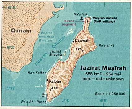
Masirah Island (Arabic: جَزِيْرَة مَصِيْرَة, romanized: Jazīrat Maṣīrah), also referred to as Mazeira Island or Wilāyat Maṣīrah (Arabic: وِلَايَة مَصِيْرَة), is an island off the east coast of mainland Oman in the Arabian Sea, and the largest island of the country. It is 95 km (59 mi) long north–south, between 12 and 14 km (7.5 and 8.7 mi) wide, with an area of about 649 km2, and a population estimated at 12,000 in 12 villages mainly in the north of the island (9,292 as of the census of 2003, of which were 2,311 foreigners). Administratively, it forms one of the five provinces (Wilayah, plural Wilayat) of the Ash Sharqiyah South Governorate. Previously it was a province of the Ash Sharqiyah Region. The principal village is Raʾs-Ḥilf (Arabic: رَأْس حِلْف) in the northern part of the island. It contains a Royal Air Force of Oman air base and a fish factory, as well as a few small towns. Previously, the BBC had a relay facility consisting of both HF and MF broadcasting transmitters stationed there. Most of the island's interior is deserted, with access to the island only possible by a small ferry for cars or by Royal Air Force of Oman Airbus A320 or Lockheed C-130 Hercules flights.
This article needs additional citations for verification. (March 2012) |
Native name: مَصِيْرَة | |
|---|---|
 | |
 Masirah | |
| Geography | |
| Location | Arabian Sea |
| Coordinates | 20°28′16″N 58°48′55″E |
| Major islands | 1 |
| Area | 649 km2 (251 sq mi) |
| Length | 95 km (59 mi) |
| Width | 12–14 km (7.5–8.7 mi) |
| Highest elevation | 256 m (840 ft) |
| Highest point | Jabal Madrub |
| Administration | |
Oman | |
| Region | Ash Sharqiyah Region |
| Wilayah (Province) | Masirah |
| Largest settlement | Ras-Hilf |
| Demographics | |
| Population | 13,902 [1] |
| Pop. density | 21.26/km2 (55.06/sq mi) |
The main industries are fishing and traditional textile manufacturing. Formerly, traditional shipbuilding was important.
History
Neolithic, Bronze Age and Iron Age archaeological sites are dotted over the island, with one study finding shell middens dating to 6000BC, stone axes from 3000BC and fish line sinkers from 4000BC[2] The Magan Civilization was present, with archaeological records from 2000-2700BC, Indus region pottery shards, and local copper mining in small quantities around 1500BC.
There was occupation by the Portuguese navy in the sixteenth century.[2] The modern history of the island is little researched, but we know the fishermen were accomplished sailors, constructed their own boats, and trade with the mainland was well advanced.[3] In the 1950s the sheikh lived on the East coast at Ra's al Ya.[4]
Landscape
The rugged terrain of the island and surrounding rough coastline has led to the appearance of many wrecked dhows on the beaches of the island, most of them well preserved by the salt water and intense heat. About 2:20 a.m. on 21 September 1835, the USS Peacock grounded on a coral reef. At high noon, the latitude was determined to be 20° 00′ north, and the longitude 58° 5″ east. Peacock later obtained this letter from the Palinurus:[5]
I certify that during the period I have navigated the Arabian coast, and been employed in the trigonometrical survey of the same, now executing by order of the Bombay government, that I have ever found it necessary to be careful to take nocturnal as well as diurnal observations, as frequent as possible, owing to the rapidity and fickleness of the currents, which, in some parts, I have found running at the rate of three and four knots, and I have known the Palinurus set between forty and fifty miles dead in shore, in a dead calm, during the night. It is owing to such currents, that I conceive the United States ship of war Peacock run aground, as have many British ships in previous years, on and near the same spot; when at the changes of the monsoons, and sometimes at the full and change, you have such thick weather, as to prevent the necessary observations being taken with accuracy and the navigator standing on with confidence as to his position, and with no land in sight, finds himself to his sorrow, often wrong, owing to a deceitful and imperceptible current, which has set him with rapidity upon it. The position of Mazeira Island, is laid down by Owen many miles too much to the westward.
Given under my hand this 10th day of November, 1835.
S. B. Haines. Commander of the Honourable East India Company's surveying brig Palinurus.
To sailing master, John Weems, U. S. Navy.
The ocean bottom environment surrounding Masirah is hostile as the majority of the area is covered in either sand or hard rock. There is a swift current flowing through the area with a very sharp halocline visible on the surface of the ocean. The water depth nearby is around 10 m and is not conducive to side-scan sonar searches due to the shallow water and choppy surface conditions. Despite the poor quality ocean bottom, the area is very productive with marine fisheries, and any hard objects (barrels, engines) are immediately colonized by local fauna.
During summer there is normally a constant strong wind which is ideal for kite and windsurfers. Big waves are a result of the wind on the sea side and is so also attractive for wave surfers. Kite and windsurfers can pick spots around the island according to their skill and what conditions they prefer.[citation needed]
On 5–6 June 2007, 7000 people on the island were forced to temporarily leave their homes due to the high storm waves produced by the powerful Cyclone Gonu, the strongest to hit the Persian Gulf region in 60 years.
Geography

 | |
| Location | Masirah Island, Oman |
|---|---|
| Coordinates | 20°10′17″N 58°38′23″E |
| Tower | |
| Constructed | 2014 |
| Construction | concrete (foundation), fiberglass (tower) |
| Height | 10 m (33 ft) |
| Shape | cylinder |
| Markings | stripe (red and white, horizontal direction) |
| Power source | solar power |
| Light | |
| Focal height | 89 m (292 ft) |
| Characteristic | Fl W 10s |
Located about 19 km (12 mi) off the east side of Barr al Hikman, the island is generally hilly, especially on its east side. The hills along the east side of the island are separated from the island coast by a narrow sandy plain; they run nearly its entire length. A steep plateau stands in the middle of the range on the northeast side of the island. Along the west side of the island, there are a few low hills separated from the east range by an extensive sandy plain marked by several hillocks:[citation needed]
- Jabal Madrub, a 256 m (840 ft) high mountain, stands about 13 km (43,000 ft) south of the north end of the island.
- Ras Abu Rasas, the south extremity of Al Masirah, is low and rocky. Jabal Suwayr (Jabal al Hilm), a conspicuous conical hill, rises to a height of 153 m (502 ft), about 3 km (1.9 mi) north-northeast of Ras Abu Rasas.
- Ras Kaydah, a small and rocky headland, has a conspicuous, conical hill about 20 m (66 ft) high nearby. There are small islets 600 m (2,000 ft) east and 4 km (2.5 mi) north of Ras Kayda.
- The coast between Ras Kaydah and Ras Zafaranat, about 27 km (17 mi) to the northeast, is regular with a few small rounded projections and a low rocky beach. Haql (Hakkan), a small village in a grove of trees, lies close to the shore about eight km north of Ras Kaydah.
- Ras Zafaranat is rocky with hills rising abruptly. Between Ras Abu Rasas and Ras Kaydah, about 18 km (11 mi) to the northeast, the coast is indented by small, sandy bays fringed by rocks.
- Ras al-Ya, about 3 km (1.9 mi) northeast of Ras Zafaranat, is the east extremity of the island and consists of a prominent bluff rising to a ridge of hills which extend westward to the center of the island. A conspicuous peak, 99 m (325 ft) high, stands about 3 km (1.9 mi) west-northwest of Ras al-Ya.
- Jabal Madrub rises about 5 km (3.1 mi) farther west-northwest.
- Ras al-Jazirah, about six km north-northwest of Ras al-Ya, is rocky and well-marked by a black patch on its south side. A sharp peak, rising to a height of 95 m (312 ft), stands about 3 km (1.9 mi) west of this point.
- Jazirat Thukhayr, a sandy islet close north of Ras al-Jazirah, lies on a drying reef connected to the shore. Drying rocks extend up to 300 m (980 ft) off the eastern extremity of the islet.
- The coast between Ras al Jazirah and Ras Qudufah, the northeast extremity of the island, about 11 km (6.8 mi) further north-northwest, is indented by a bay. Ras Qudufah, consisting of two rocky projections about 800 m (2,600 ft) apart, rises to Jabal al-Jidufa, about 64 m (210 ft) high, a short distance inland. A cairn stands on a hill close south of Jabal al-Jidufa, and a small monument stands close southwest of Ras Qudufah.
Climate
Saiq has a hot desert climate (Köppen climate classification BWh) with hot summers and warm winters. Precipitation is low, and falls mainly from February to April as well as in the brief monsoon season from June to August.
| Climate data for Masirah Island | |||||||||||||
|---|---|---|---|---|---|---|---|---|---|---|---|---|---|
| Month | Jan | Feb | Mar | Apr | May | Jun | Jul | Aug | Sep | Oct | Nov | Dec | Year |
| Record high °C (°F) | 32.4 (90.3) |
33.7 (92.7) |
37.5 (99.5) |
42.7 (108.9) |
44.0 (111.2) |
45.3 (113.5) |
41.6 (106.9) |
41.4 (106.5) |
36.8 (98.2) |
40.0 (104.0) |
37.0 (98.6) |
31.1 (88.0) |
45.3 (113.5) |
| Average high °C (°F) | 26.0 (78.8) |
26.9 (80.4) |
29.8 (85.6) |
33.4 (92.1) |
35.4 (95.7) |
34.6 (94.3) |
31.8 (89.2) |
30.7 (87.3) |
30.7 (87.3) |
32.0 (89.6) |
29.8 (85.6) |
27.1 (80.8) |
30.7 (87.2) |
| Daily mean °C (°F) | 22.1 (71.8) |
22.8 (73.0) |
25.2 (77.4) |
28.4 (83.1) |
30.4 (86.7) |
29.9 (85.8) |
27.5 (81.5) |
26.4 (79.5) |
26.6 (79.9) |
27.2 (81.0) |
25.7 (78.3) |
23.4 (74.1) |
26.3 (79.3) |
| Average low °C (°F) | 18.2 (64.8) |
18.7 (65.7) |
20.7 (69.3) |
23.8 (74.8) |
25.9 (78.6) |
25.6 (78.1) |
23.6 (74.5) |
22.5 (72.5) |
22.8 (73.0) |
22.6 (72.7) |
21.6 (70.9) |
19.8 (67.6) |
22.1 (71.9) |
| Record low °C (°F) | 8.9 (48.0) |
12.1 (53.8) |
13.4 (56.1) |
16.3 (61.3) |
19.6 (67.3) |
21.6 (70.9) |
20.0 (68.0) |
19.0 (66.2) |
20.0 (68.0) |
18.5 (65.3) |
15.4 (59.7) |
9.4 (48.9) |
8.9 (48.0) |
| Average precipitation mm (inches) | 7.5 (0.30) |
16.3 (0.64) |
12.5 (0.49) |
10.2 (0.40) |
1.5 (0.06) |
21.1 (0.83) |
11.6 (0.46) |
9.9 (0.39) |
0.4 (0.02) |
0.0 (0.0) |
1.2 (0.05) |
6.9 (0.27) |
99.1 (3.91) |
| Average relative humidity (%) | 68 | 70 | 71 | 67 | 69 | 73 | 78 | 79 | 78 | 71 | 69 | 67 | 72 |
| Mean monthly sunshine hours | 287.2 | 259.1 | 297.3 | 311.2 | 346.6 | 268.6 | 238.1 | 248.0 | 283.6 | 317.9 | 299.5 | 288.9 | 3,446 |
| Source: NOAA (1980-1990) [6] | |||||||||||||
Tourism

Masirah Island opened for tourism in the 1990s.[7] One can still only get to the island by ferry, managed by the National Ferry Company www.nfc.om, which runs six times a day between Shannah to Masirah.
There is now a four-star-hotel (Masirah Island Resort on the north east coast), five other listed hotels, and a kitesurfing camp. For kitesurfers, Masirah is an attractive spot in summer because of the monsoon winds which blow steadily at over 20 knots (37 km/h; 23 mph).[8] Rental cars are available on the island.
More eco-tourism possibilities exist.[9]
Military base

The British established a military presence on Masirah in the 1930s. A small stone building, a fuel store for land based aircraft flying between Aden and Muscat, stood at the midpoint of the island on the west side, and had a stone above the door inscribed "RAF 1936". Reputedly, the fuel store was locked and visiting aircrew used to bring a key, refuel from cans, lock the store and fly onwards.[citation needed]
A dispute between British forces and the local inhabitants took place in 1942, led by one of two local sheikhs, who were eventually forced to flee the island.[10]
During WW II, The British paid the Sultan of Muscat a stipend of £18,000 per annum for affording British forces 'necessary facilities', which included Masirah. A Cabinet Office memorandum of 1945 recommended the acquisition of Masirah on a 99-year lease, US interests in the island notwithstanding (During World War II the United States also had a base on the island.). The Sultan was to be offered an annual payment of £3,750 with an initial premium of £7,500.[10] The base continued to expand into the 1970s, supporting British and Oman forces fighting insurgents during the Dhofar Rebellion and providing transit facilities for long-distance RAF flights.
The British military presence at RAF Masirah extended until 31 March 1977, when Sultan of Oman's Air Force (now the Royal Air Force of Oman) took over the base, which became first SOAF Masirah and then RAFO Masirah. In the 1970s, the base included a HF communications hub and a rear link to SAS units and british Royal Engineer Units based in Oman in support of the actions against rebels in the south of the country (RAF Salalah). United States' units used Masirah Island as a staging base in Operation Eagle Claw, the unsuccessful 1980 attempt to free US hostages then held in Iran. The island was subsequently used as a staging area for operations into Afghanistan in 2001.[citation needed]
As of 2009[update], the American private military contractor DynCorp had a contract to staff and serve a US military storage-depot at this base.[citation needed]
Radio Relay Station
In 1966 Masirah took on a new role, it became the base for the British Middle East Relay Station. This was built by the British Diplomatic Wireless Service https://en.wikipedia.org/wiki/Diplomatic_Wireless_Service to be a relay station for the World Service of the BBC. The station had been previously based in Somalia and Perim called the East Africa Relay Station. These stations were both closed as the politics of the region changed. The same transmitters were used in all three stations and were sent back to the DWS main technical base https://en.wikipedia.org/wiki/Aspidistra_(transmitter) at Crowborough https://en.wikipedia.org/wiki/Crowborough in the UK for thorough rebuilds prior to their being set up in their new homes. The station was badly damaged by a Hurricane in 1976 but was rebuilt and handed over to the BBC in 1985. [11]
Ecology
s' nesting locations]]
The island is an important hatching ground for loggerhead sea turtles, similar in importance to the beaches at Ras al Hadd and nearby Ras al-Jinz as a hatching ground for green sea turtles.[12] Critically endangered humpback whales also migrate in the waters surrounding the island and Masirah gulf.[13][14]
Economy
Historically, the island had copper ore mining dating back to the Bronze Age.[15]
The fishing industry, building on a long tradition, is centered on the north coast, and includes a fish processing plant.[16]
See also
- Duqm
- List of lighthouses in Oman[17]
- Socotra, another hilly/mountainous island off the coast of the Horn of Africa
References
- "Population - DATA PORTAL". National Centre for Statistics & Information. Retrieved 15 October 2021.
- Charpentier, Vincent, et al. “Conquering New Territories: When the First Black Boats Sailed to Masirah Island.” Proceedings of the Seminar for Arabian Studies, vol. 43, , 2013, pp. 85–98, http://www.jstor.org/stable/43782870.
- Blue, Lucy, et al. “Maritime Footprints: Examining the Maritime Cultural Landscape of Masirah Island, Oman, Past and Present.” Proceedings of the Seminar for Arabian Studies, vol. 44, 2014, pp. 53–68, http://www.jstor.org/stable/43782902.
- de Gaury, Gerald. “A Note on Masira Island.” The Geographical Journal, vol. 123, no. 4, 1957, pp. 499–502, https://doi.org/10.2307/1790352.
- Ruschenberger, William Samuel Waithman (24 July 2007) [1837]. "Chapter VI: Voyage from Zanzibar to Muscat". A Voyage Round the World: Including an Embassy to Muscat and Siam in 1835, 1836 and 1837. Harper & brothers. pp. 54–62. OCLC 12492287. Retrieved 25 April 2012.
- "Masirah Climate Normals 1980-1990". National Oceanic and Atmospheric Administration. Retrieved 15 January 2013.
- "Oman's Desert Island", The Guardian, 4 September 2010, retrieved 17 October 2021
- Riding the desert winds of the Masirah Island, Surfer Today, retrieved 17 October 2021
- Shawky Mansour, Talal Al-Awhadi, Salim Al-Hatrushi. Geospatial based multi-criteria analysis for ecotourism land suitability using GIS & AHP: a case study of Masirah Island, Oman, Journal of Ecotourism 19, no.22 (Sep 2019): 148–167. https://doi.org/10.1080/14724049.2019.1663202
- Top Secret Cabinet Office Memorandum by the Secretary of State for Air and Secretary of State for India (CP 45 3) of 29 May 1945. The National Archives, Kew.
- Norman McLeod Spalding DWS Engineer 1926-2022
- Oman: a MEED practical guide John Whelan - 1984 "Five species occur: the loggerhead, green, hawksbill, Olive Ridley and leather-back turtles. Of these, two species commonly breed in Oman — the loggerhead in Masirah, and the green turtle on the beaches of Ras al-Hadd."
- "MECA Open Data". Ministry of Environment and Climate Affairs. Retrieved 1 January 2018.
- Minton G. (2017), Pre-print manuscript published on humpback whales in the Persian Gulf, Arabian Sea Whale Network, retrieved 21 September 2017
- Prothero, G.W. (1920). Arabia. London: H.M. Stationery Office. p. 98.
- Moza A. Al-Busaidi, David J. Jukes, Shekar Bose Seafood safety and quality: An analysis of the supply chain in the Sultanate of Oman, Food Control 59 (Jan 2016): 651–662. https://doi.org/10.1016/j.foodcont.2015.06.023
- Rowlett, Russ. "Lighthouses of Oman". The Lighthouse Directory. University of North Carolina at Chapel Hill. Retrieved 13 October 2016.
External links
Capital: Sur | |
| Wilayats (provinces) |
|
| Villages |
|
Authority control | |||
|---|---|---|---|
| General |
| ||
| Other |
| ||
| Additional |
| ||
На других языках
[de] Masira
Masira (arabisch مصيرة, DMG Maṣīra; lateinisch: Zenobia (römische Bezeichnung der Insel in der Antike)[1]) ist eine Insel an der Ostküste des Oman. Das 649 km² große Eiland ist 95 km lang und 12–14 km breit. Die etwa 12.000 Bewohner der Insel wohnen zum größten Teil in 12 Orten welche an der Nordseite der Insel liegen. Masira gehört administrativ zum Gouvernement Dschanub asch-Scharqiyya und enthält das südlichste Territorium dieser Region.- [en] Masirah Island
[fr] Masirah
Masirah (en arabe : مصيرة) est une île de l'océan Indien située au large de la côte orientale du Sultanat d'Oman.[it] Maṣīra
L'isola di Maṣīra (in arabo: جزيرة مصيرة, Jazīrat Maṣīra) o Masira o Masirah (àrab: مصيرة) si trova nella parte dell'oceano Indiano che viene chiamato Mar Arabico, al largo della costa dell'Oman, del quale fa parte.[ru] Масира
Маси́ра (араб. مصيرة) — остров в Аравийском море, вблизи восточного побережья Омана. Протянулся с северо-востока на юго-запад на 95 км при ширине от 12 до 14 км. Площадь острова составляет 649 км². Население — около 12 000 человек (по данным переписи 2003 года — 9292 человека), сосредоточено главным образом в северной части острова.Другой контент может иметь иную лицензию. Перед использованием материалов сайта WikiSort.org внимательно изучите правила лицензирования конкретных элементов наполнения сайта.
WikiSort.org - проект по пересортировке и дополнению контента Википедии