geo.wikisort.org - Isola
L'isola di Maṣīra (in arabo: جزيرة مصيرة, Jazīrat Maṣīra) o Masira o Masirah (àrab: مصيرة) si trova nella parte dell'oceano Indiano che viene chiamato Mar Arabico, al largo della costa dell'Oman, del quale fa parte.
| Maṣīra مصيرة | |
|---|---|
 | |
| Geografia fisica | |
| Localizzazione | Mar Arabico |
| Coordinate | 20°28′16″N 58°48′55″E |
| Superficie | 649 km² |
| Dimensioni | 95 × 12-14 km |
| Altitudine massima | (Jabal Madhrūb) 256 m s.l.m. |
| Geografia politica | |
| Stato | |
| Governatorato | al-Sharqiyya |
| Wilaya | Masira |
| Centro principale | Dawwāh |
| Demografia | |
| Abitanti | 12.000 |
| Cartografia | |
 | |
 Maṣīra | |
 Maṣīra | |
| voci di isole dell'Oman presenti su Wikipedia | |
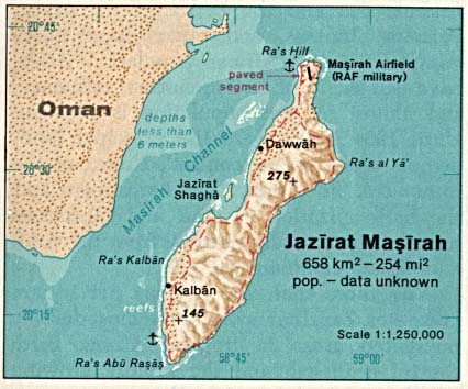
Da nord a sud è lunga circa 65 km, mentre ha una larghezza che varia tra i 12 ed 16 km, per una superficie totale di 649 km²; la popolazione è di circa 12.000 abitanti ed il centro principale è Dawwāh, nella porzione settentrionale dell'isola. Le principali attività sono la pesca e le manifatture tessili tradizionali. Nel passato l'isola ha ospitato basi militari britanniche e poi statunitensi.
Altri progetti
 Wikimedia Commons contiene immagini o altri file su Maṣīra
Collegamenti esterni
- Masirah: Tales from a Desert Island, su dataxinfo.com. URL consultato il 27 novembre 2010 (archiviato dall'url originale il 4 giugno 2007).
| Controllo di autorità | VIAF (EN) 315526354 |
|---|
На других языках
[de] Masira
Masira (arabisch مصيرة, DMG Maṣīra; lateinisch: Zenobia (römische Bezeichnung der Insel in der Antike)[1]) ist eine Insel an der Ostküste des Oman. Das 649 km² große Eiland ist 95 km lang und 12–14 km breit. Die etwa 12.000 Bewohner der Insel wohnen zum größten Teil in 12 Orten welche an der Nordseite der Insel liegen. Masira gehört administrativ zum Gouvernement Dschanub asch-Scharqiyya und enthält das südlichste Territorium dieser Region.[en] Masirah Island
Masirah Island (Arabic: جَزِيْرَة مَصِيْرَة, romanized: Jazīrat Maṣīrah), also referred to as Mazeira Island or Wilāyat Maṣīrah (Arabic: وِلَايَة مَصِيْرَة), is an island off the east coast of mainland Oman in the Arabian Sea, and the largest island of the country. It is 95 km (59 mi) long north–south, between 12 and 14 km (7.5 and 8.7 mi) wide, with an area of about 649 km2, and a population estimated at 12,000 in 12 villages mainly in the north of the island (9,292 as of the census of 2003, of which were 2,311 foreigners). Administratively, it forms one of the five provinces (Wilayah, plural Wilayat) of the Ash Sharqiyah South Governorate. Previously it was a province of the Ash Sharqiyah Region. The principal village is Raʾs-Ḥilf (Arabic: رَأْس حِلْف) in the northern part of the island. It contains a Royal Air Force of Oman air base and a fish factory, as well as a few small towns. Previously, the BBC had a relay facility consisting of both HF and MF broadcasting transmitters stationed there. Most of the island's interior is deserted, with access to the island only possible by a small ferry for cars or by Royal Air Force of Oman Airbus A320 or Lockheed C-130 Hercules flights.[fr] Masirah
Masirah (en arabe : مصيرة) est une île de l'océan Indien située au large de la côte orientale du Sultanat d'Oman.- [it] Maṣīra
[ru] Масира
Маси́ра (араб. مصيرة) — остров в Аравийском море, вблизи восточного побережья Омана. Протянулся с северо-востока на юго-запад на 95 км при ширине от 12 до 14 км. Площадь острова составляет 649 км². Население — около 12 000 человек (по данным переписи 2003 года — 9292 человека), сосредоточено главным образом в северной части острова.Текст в блоке "Читать" взят с сайта "Википедия" и доступен по лицензии Creative Commons Attribution-ShareAlike; в отдельных случаях могут действовать дополнительные условия.
Другой контент может иметь иную лицензию. Перед использованием материалов сайта WikiSort.org внимательно изучите правила лицензирования конкретных элементов наполнения сайта.
Другой контент может иметь иную лицензию. Перед использованием материалов сайта WikiSort.org внимательно изучите правила лицензирования конкретных элементов наполнения сайта.
2019-2026
WikiSort.org - проект по пересортировке и дополнению контента Википедии
WikiSort.org - проект по пересортировке и дополнению контента Википедии