geo.wikisort.org - Mountains
The Colombian Massif (from the Spanish Macizo Colombiano), also known colloquially as Nudo de Almaguer, refers to a group of mountains within the Andes of south central Colombia. The massif is mainly within the area of the Cauca, Huila, and Nariño Departments. To the south is the Pasto Massif and to the north begins the Central and Eastern Andes.
| Colombian Massif | |
|---|---|
 Puracé Volcano | |
| Highest point | |
| Peak | Puracé |
| Elevation | 4,646 m (15,243 ft) |
| Coordinates | 1°45′00″N 76°30′00″W |
| Dimensions | |
| Area | 32,682 km2 (12,619 sq mi) |
| Geography | |
 Colombian Massif | |
| Country | Colombia |
| Region | Cauca, Huila, Nariño |
Geography
The total area is 32,682 km2 (12,619 sq mi), which is distributed as follows: 13,716 km2 (5,296 sq mi) of forests, 15,423 km2 (5,955 sq mi) of agroecosystems, 2,567 km2 (991 sq mi) of páramos, 43 km2 (17 sq mi) of snow zone, 924 km2 (357 sq mi) have xerophytic vegetation and 9 km2 (3.5 sq mi) of urban settlements. The altitude varies between 2,600 m (8,500 ft) and 4,646 m (15,243 ft).[1]
This area is identified as the source of 70% of the Colombian safe water for human consumption and irrigation. The headwaters of the Magdalena and Cauca Rivers (Caribbean slope), Caquetá and Putumayo Rivers (Amazon Basin) and the Patía River (Pacific slope).
The massif contains 362 high mountain bodies of water, 13 páramos and other ecosystems rich in flora and fauna. From south to north are the páramos of Cutanga, Letero, Las Papas (Potatoes), Apio (Celery) and Buey (Ox). Sotará and Puracé are the prominent volcanoes of the area, the latter being within the Puracé National Natural Park.
Very few people have traversed the mountains of this region because it is covered by rugged terrain and an impenetrable and cold páramo environment, both of which are natural guardians which preserve the water sources that provide water for half of Colombia before emptying into the sea.
 Cerro de Lerma
in Cauca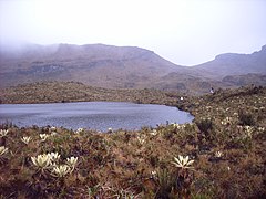 Las Reginas


References
External links
Mountain ranges of Colombia | ||||||||||
|---|---|---|---|---|---|---|---|---|---|---|
| Colombian Andes |
|  | ||||||||
| Isolated ranges | ||||||||||
На других языках
- [en] Colombian Massif
[es] Macizo Colombiano
El macizo colombiano, también llamado nudo de Almaguer, es la estrella hídrica más importante de Colombia. Está constituido por un conjunto montañoso de los Andes colombianos que cubre a los departamentos de Huila, Cauca, Nariño y Putumayo, al norte del nudo de los Pastos.[fr] Nœud d'Almaguer
Le nœud d'Almaguer (espagnol : Nudo de Almaguer), également appelé massif colombien (espagnol : Macizo colombiano), est un massif montagneux situé dans la cordillère des Andes, en Colombie.[it] Macizo Colombiano
Il Macizo Colombiano, anche chiamato Nodo di Almaguer (in spagnolo Nudo de Almaguer)[1], è la stella idrica più importante della Colombia. È costituito da una congiunzione montuosa dei Cammini colombiani, la quale si estende nei dipartimenti di Cauca, Huila e Nariño.[ru] Колумбийский массив
Колумбийский массив (исп. Macizo Colombiano, также называемый Nudo de Almaguer) — горный массив в составе Анд в южной части центральной Колумбии. Он располагается в основном в пределах департаментов Каука, Уила и Нариньо. К юге от него располагается массив Пасто (исп. Nudo de los Pastos), а к северу начинаются Центральная и Восточная Кордильеры.Другой контент может иметь иную лицензию. Перед использованием материалов сайта WikiSort.org внимательно изучите правила лицензирования конкретных элементов наполнения сайта.
WikiSort.org - проект по пересортировке и дополнению контента Википедии