geo.wikisort.org - Island
Misima (formerly called St. Aignan) is a volcanic island in the northwest of Louisiade Archipelago within Milne Bay Province of Papua New Guinea.
Nickname: St. Aignan Island | |
|---|---|
 Misima Island photo | |
 Misima Island | |
| Geography | |
| Location | Oceania |
| Coordinates | 10°41′S 152°43′E |
| Archipelago | Louisiade Archipelago |
| Adjacent bodies of water | Solomon Sea |
| Total islands | 3 |
| Major islands |
|
| Area | 215 km2 (83 sq mi) |
| Length | 40 km (25 mi) |
| Width | 10 km (6 mi) |
| Highest elevation | 1,036 m (3399 ft) |
| Highest point | Mount Koia Tau or Oia Tau First Recorded Ascent:24 December 2016 by Kolbe Bare and two other Misimans |
| Administration | |
Papua New Guinea | |
| Province | |
| District | Samarai-Murua District |
| LLG[1] | Louisiade Rural Local Level Government Area |
| Island Group | Misima Islands |
| Largest settlement | Bwagaoia (pop. 2680) |
| Demographics | |
| Population | 19,330 (2014) |
| Pop. density | 89.9/km2 (232.8/sq mi) |
| Ethnic groups | Papauans, Austronesians, Melanesians. |
| Additional information | |
| Time zone |
|
| ISO code | PG-MBA |
| Official website | www |


History
Misima Island was inhabited by Austronesians since about 1500 BC. The island was sighted in 1768 by French captain Louis Antoine de Bougainville and explored 1793 by French explorer Antoine Bruni d'Entrecasteaux. Misima island owes its name to Élisabeth-Paul-Édouard de Rossel, which was a lieutenant of the Counter admiral Antoine Bruny d'Entrecasteaux during his journey of scientific exploration. In 1888 the British Empire annexed Misima Island, and it became part of British New Guinea (since 1904 - the Territory of Papua administered by Australia).
Gold was discovered on Misima late in 1888.[2] By March 1889, eighty men were on the island digging for gold, and a storekeeper had set up a business.[3]
Since 1975, Misima belongs to the independent state of Papua New Guinea. A gold and silver mine was opened on the island in 1990, by an international corporation. The mines provided plenty of work for the islanders. however, that mine was officially closed in 2004, because of excessive load on the environment and public health hazards.[4]
Politics
The island is within the Samarai Murua District.
Geography
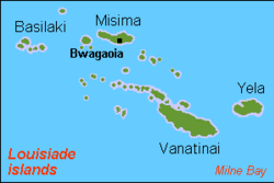
The island measures 40 km by 10 km and has an area of 214,5 km². It is located some 20 km north of the northwest extreme of the barrier reef of Vanatinai at Isu Raua Raua Island, and 80 km northwest of Vanatinai Island itself.
Misima is mountainous and densely forested. Mt. Koia Tau, at a height of 1,036 meters, is the highest peak of the Louisiade Archipelago.
It was not until 24 December 2016 when Kolbe Bare, a Papua New Guinean geologist, and two Misimans, David Kaliton and Kaliton Ada, made the first recorded ascent to the Top of Oia Tau.[4] It was noted by Kolbe that even though the mountain is close to the sea, Higher altitude vegetation covers the top of the mountain at the time of ascent.
Climate
The local climate is tropical, moderated by northeast trade winds, with a dry season from 1 December to 31 May, and a wet season from 1 June to 30 November. it is usually very humid. Since it is fairly close to the equator, the temperature does not fluctuate much between winter and summer.
Economy
Misima island is known as a mining island. A huge mine operated many years on the island. The mine was a joint venture by Placer Dome Inc (owning 80%) and the state-owned Orogen Minerals Ltd. In March 2012 Barrick closed its post closure monitoring office in Bwagaoia having successfully rehabilitated the mine and mill sites.
Since 2004 when the mine closed, artisanal mining has become a major source of income in the island, with an association Misima Alluvial Gold Mining Association (MAGMA) starting in 2007. Other sources of income, especially for people living on the north coast, are cash crops of coconuts, copra, and cacao. A commercial fisheries project has been proposed, but has not been developed yet.
Demographics
The island has a population of 19,330, spread across 78 villages, Misima is the most heavily populated island in the Louisiade Archipelago. By area, it is the third largest, after Vanatinai and Rossel Island. Since the mines have closed, there are signs of population decrease. people are moving to Alotau for jobs.
Urbanization
The main town of the island and the seat of the district is Bwagaoia, located on the southeast corner of the island. Other villages are Hinauta, Boiou, Gulewa, Bagilina, Liak, Siagara, Eiaus (on the eastern north coast, reachable by road from Bwagaoia), Gulewa and Ewena (on the western north coast), and Bwagabwaga, Gaibobo and Alhoga (on the south coast).[5]
Cities
| Village Name | Ward | Population | Coordinates |
|---|---|---|---|
| Bwagaoia | 03 Bwagaoia | 2680 | 10.679228°S 152.846404°E |
| Balmatana | 30 Baimatana | 323 | 10.673647°S 152.866527°E |
| Hinauta | 04 Hinauta | 509 | 10.663595°S 152.860578°E |
| Lobwa | 31 Lobwa | 285 | 10.652514°S 152.852762°E |
| Gigig | 05 Kaubwaga | 627 | 10.64805°S 152.851101°E |
| Kaubwaga | 05 Kaubwaga | 504 | 10.646257°S 152.848137°E |
| Boiou | 06 Boiou | 640 | 10.627445°S 152.814962°E |
| Ginul | 06 Boiou | 262 | 10.62614°S 152.804615°E |
| Hopitkahin | 07 Siagara East | 862 | 10.610698°S 152.791768°E |
| Kalotawa | 08 Siagara West | 1024 | 10.629022°S 152.766261°E |
| Gulewa | 09 Gulewa | 768 | 10.6379°S 152.738°E |
| Kakamwa | 09 Gulewa | 329 | 10.64°S 152.7227°E |
| Liak | 10 Liak | 1523 | 10.65°S 152.703°E |
| Bagilina | 12 Bagilina | 636 | 10.655126°S 152.674738°E |
| Lalama | 12 Bagilina | 578 | 10.649457°S 152.656382°E |
| Ewena | 13 Ewena | 516 | 10.622°S 152.56°E |
| Ebora | 14 Ebora | 679 | 10.62956°S 152.524873°E |
| Bwana | 32 Bwana | 138 | 10.661051°S 152.588471°E |
| Bwagabwaga | 15 Bwagabwaga | 535 | 10.686105°S 152.710968°E |
| Gigimwani | 16 Awaibi | 501 | 10.698386°S 152.695093°E |
| Awaibi | 16 Awaibi | 252 | 10.702186°S 152.70222°E |
| Bwaeyam | 16 Awaibi | 1010 | 10.707154°S 152.71499°E |
| Alhoga | 17 Alhoga | 379 | 10.713743°S 152.741871°E |
| Lohola | 17 Alhoga | 300 | 10.716368°S 152.75533°E |
| Mwana (Tribes of Eaus River) | 18 Eaus North | 888 | 10.675°S 152.753°E |
| Eaus (Palapa) | 19 Eaus South | 980 | 10.696203°S 152.765643°E |
| Abalouna | 19 Eaus South | 564 | 10.696653°S 152.777925°E |
| Quartz Mountain (Misima mines) | 02 Narian | 222 | 10.69°S 152.79°E |
| Narian | 02 Narian | 836 | 10.690259°S 152.812086°E |
| Gaibobo | 20 Gaibobo | 731 | 10.691979°S 152.820156°E |
Religion
About half the population identified themselves as members of a Christian church. see Religion in Papua New Guinea for more info.
Language
The main language of the island is also called Misiman, though many residents speak English and also Tok Pisin as a third language.
Culture
This section is empty. You can help by adding to it. (August 2017) |
Education
This section is empty. You can help by adding to it. (August 2017) |
Transportation
Misima has a working airport (IATA: MIS, ICAO: AYMM) (four flights weekly to the mainland (POM via Alotau) through Airlines of Papua New Guinea, and one charter run by Porgera Joint Venture, a high school (grades 7-12), a small market, a few small stores and a clinic/hospital, a post office,--all of which are located in Bwagaoia. There are ferries from Alotau which service Misima Island, costing around K100 and taking 17 hours.
Flora and fauna
The following mammals are present on Misima Island:
- Polynesian rat (introduced)
- Wild boar (introduced)
- Eastern common cuscus
- Sugar glider
- Grassland rat
- Eastern rat
- Panniet naked-backed fruit bat
- Island tube-nosed fruit bat
- Small flying fox
- Common blossom bat
- Temminck's trident bat
- Spurred roundleaf bat
- Fawn leaf-nosed bat
- Diadem leaf-nosed bat
- Smaller horseshoe bat
- Misima bat
- Little bent-wing bat
- Miniopterus macrocneme
- Great bent-winged bat
- Common bent-wing bat
- Angulate pipistrelle
Other animals:
- Copiula oxyrhina
References
- LLG map
- Nelson, Hank (1976) Black, white & gold: goldmining in Papua New Guinea, 1878-1930, Canberra, Australian National University Press, p.28. ISBN 0708104878
- Nelson, p.28
- Official Web Site of the Prime Minister of Papua New Guinea[permanent dead link]
- http://rspas.anu.edu.au/lmg/masp/workingpapers/05/MIL_05_16_01.pdf [bare URL PDF]
External links
На других языках
[de] Misima
Misima, früher St. Aignan Island, ist eine Insel vulkanischen Ursprungs im Louisiade-Archipel der (Milne Bay Province von Papua-Neuguinea). Die Insel ist 40 km lang und 10 km breit, und hat eine Fläche von 202,5 km². Sie liegt gut 20 km nördlich des äußersten nordwestlichen Barriereriffs von Vanatinai, und 80 km nordwestlich dieser Insel. Misima ist gebirgig und dicht bewaldet. Der Mt. Koia Tau ist mit 1.036 Metern der höchste Gipfel des Louisiade-Archipels.- [en] Misima Island
[fr] Misima
L’île Misima est une île volcanique des Louisiades, dans la province de Baie Milne, en Papouasie-Nouvelle-Guinée.[it] Misima
Misima (nota in passato come St. Aignan) è un'isola d'origine vulcanica di Papua Nuova Guinea.[ru] Мисима (остров, Папуа — Новая Гвинея)
Мисима (англ. Misima) — остров в Тихом океане. Является территорией государства Папуа — Новая Гвинея. Административно входит в состав провинции Милн-Бей региона Папуа.Другой контент может иметь иную лицензию. Перед использованием материалов сайта WikiSort.org внимательно изучите правила лицензирования конкретных элементов наполнения сайта.
WikiSort.org - проект по пересортировке и дополнению контента Википедии