geo.wikisort.org - Island
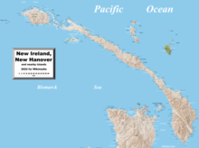
New Ireland (Tok Pisin: Niu Ailan) or Latangai, is a large island in Papua New Guinea, approximately 7,404 km2 (2,859 sq mi) in area with c. 120,000 people.[2] It is named after the island of Ireland. It is the largest island of New Ireland Province, lying northeast of the island of New Britain. Both islands are part of the Bismarck Archipelago, named after Otto von Bismarck, and they are separated by Saint George's Channel.
Native name: Niu Ailan | |
|---|---|
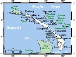 New Ireland's main towns and nearby islands | |
 New Ireland | |
| Geography | |
| Coordinates | 3.33°S 152°E |
| Archipelago | Bismarck Archipelago |
| Area | 7,404 km2 (2,859 sq mi) |
| Length | 360 km (224 mi) |
| Width | 10 km (6 mi) - 40 km (25 mi) |
| Highest elevation | 2,340 m (7680 ft) |
| Highest point | Mount Taron |
| Administration | |
Papua New Guinea | |
| Province | New Ireland Province |
| Largest settlement | Kavieng (pop. 10,600) |
| Demographics | |
| Population | 118,350[1] (2002) |
The administrative centre of the island and of New Ireland province is the town of Kavieng located at the northern end of the island. While the island was part of German New Guinea, it was named Neumecklenburg ("New Mecklenburg").
Geography


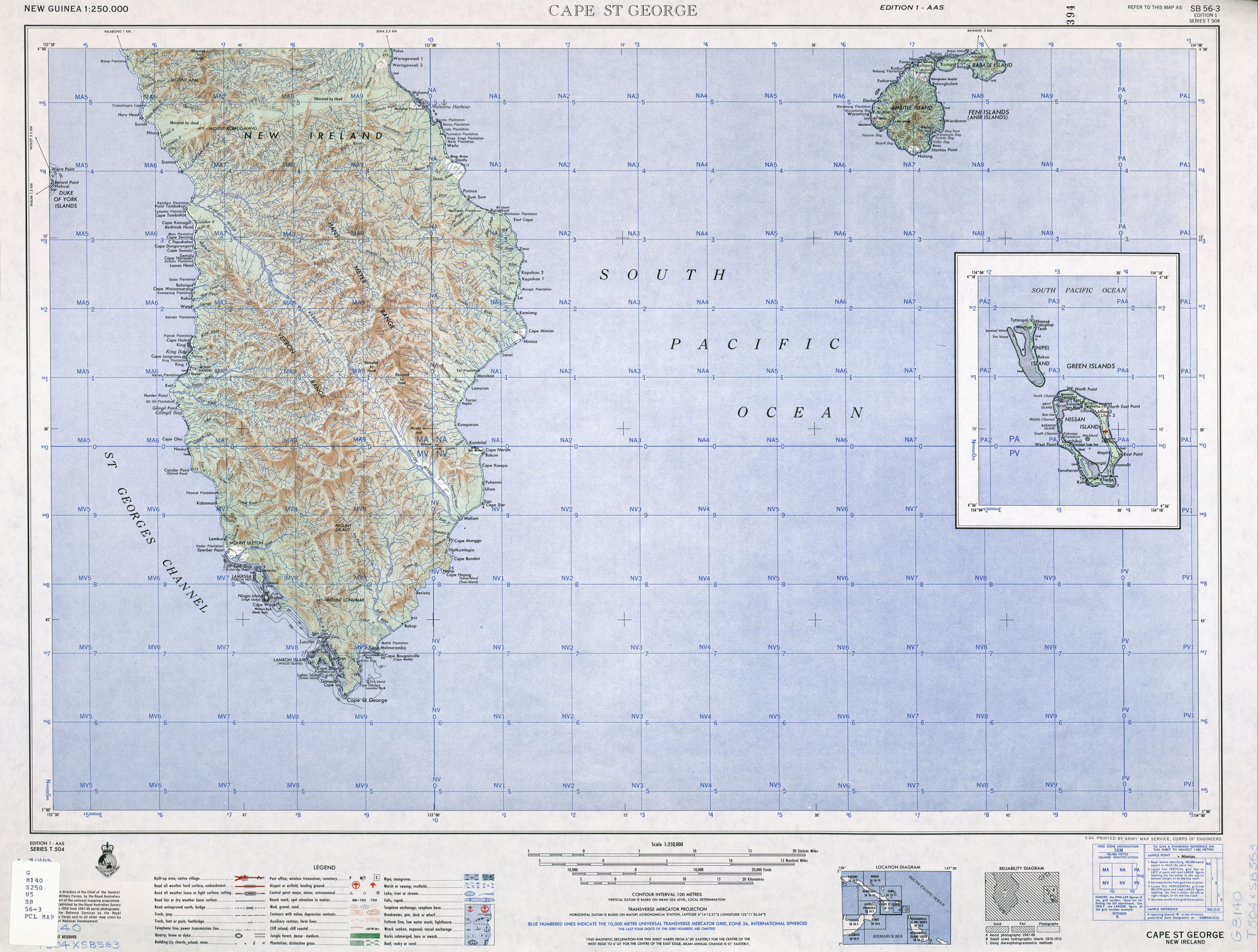
The island is part of the Bismarck Archipelago and is often described as having the shape of a musket. New Ireland is surrounded by the Bismarck Sea in the southwest and by the Pacific Ocean in the northeast.[3]
For much of its 360 km (220 mi) in length, the island's width varies between less than 10 km (6.2 mi) to 40 km (25 mi), yet the central mountainous spine is very steep and rugged. The highest peak is Mount Taron in the Hans Meyer Range (2,340 m, 7,680 ft).[4] Other mountain ranges are Tirpitz, Schleinitz, Verron and Rossel.[5] The island lies between two and five degrees south of the equator. The original land cover was primarily dense rainforest.
History
Pre-colonial period
The first inhabitants of the Bismarck Archipelago arrived around 33,000 years ago after sailing from what is now Papua New Guinea. Later arrivals included the Lapita people approximately 3,000 years ago. Three distinct cultural practices are characteristic of the native people of New Ireland: Kabai, Malagan and Tubuan.[6]
Colonial period
In 1616 the Dutch sailors Jacob Le Maire and Willem Schouten were the first Europeans to set foot on the island. Louis Antoine de Bougainville anchored here on 6 July 1768, eleven months after Philip Carteret.[7]
Whaling ships often called at the island in the 19th century, for water, wood and provisions. The first recorded whaler to visit was the Resource in 1799.[8] Islanders sometimes served as crewmen on these vessels. The last known whaling visitor was the Belvedere in 1884.[9]
In the 1870s and 1880s, the Marquis de Rays, a French nobleman, attempted to establish a French colony on the island called New France.[10] He sent four ill-fated expeditions to the island, the most famous of which caused the death of 123 settlers.
From 1885 to 1914 New Ireland was a part of German New Guinea and bore the name Neumecklenburg. Germans managed several highly profitable copra plantations and built a road to transport the goods. This road is currently in service and is named the Boluminski Highway after the German administrator of German New Guinea, Franz Boluminski. After World War I New Ireland was ceded to Australia. Australia renamed the island New Ireland, after the island of Ireland. In January 1942, during World War II, the island was captured by Japanese forces and was under their control.
Ecology
The island is part of two ecoregions. The New Britain-New Ireland lowland rain forests extend from sea level to 1000 meters elevation. The New Britain-New Ireland montane rain forests cover the mountains of New Ireland above 1000 meters elevation.
Widespread deforestation and degradation of lowland rainforest is an issue on New Ireland and the other eastern islands of Papua New Guinea (New Britain, Bougainville Island) as well as on Papua New Guinea mainland. Nearly 60% of their forests are accessible to logging, and by 2002, 63% of the accessible forests had been deforested or degraded.[11]
Culture
- Malagan – funerary arts that originate in Tabar Group, and have been imported to the northern region of New Ireland.[12]
- Tatanua – "The person who organises a tatanua performance must select the music and dancers, assemble a male chorus and acquire the masks. The masks are usually rented from one of the sculptors who makes them."[13]
- Kulap – chalk limestone funerary sculptures.[14]
References
- "New Ireland Province" (PDF). Archived from the original (PDF) on 8 August 2017. Retrieved 16 August 2014.
- "Islands by land area: New Ireland". islands.unep.ch. United Nations Environment Program. 1988.
- US Army Map Service (1964). "New Guinea Topographic Map Book, TK250, Sheet SB 56-3". University of Texas at Austin.
- "Mount Taron, Papua New Guinea". Peakbagger.com.
- "NI mountains tell a tale". Archived from the original on 5 April 2012. Retrieved 19 November 2011.
- "People & Culture". New Ireland Tourism. Archived from the original on 3 June 2013. Retrieved 16 August 2014.
- Salmond, Anne (2010). Aphrodite's Island. Berkeley: University of California Press. pp. 114. ISBN 9780520261143.
- Robert Langdon (ed.) Where the whalers went: an index to the Pacific ports and islands visited by American whalers (and some other ships) in the 19th century, Canberra, Pacific Manuscripts Bureau, 1984, p.187. ISBN 0-86784-471-X
- Langdon, p.187.
- Cahoon, Ben (2000). "Papua New Guinea". Worldttatesmen.org.
- Earth, NASA's Visible (11 August 2009). "Forest Change on New Ireland, Papua New Guinea". visibleearth.nasa.gov.
- Gunn, Michael; Phillipe Feltier (2006). New Ireland: Art of the South Pacific. Milan: Continents Editions. ISBN 88-7439-369-5.
- d'Alleva, Anne (1998). Kara Hattersley-Smith (ed.). Arts of the Pacific Islands. New York: Perspectives – Harry N. Abrams, Inc., Publishers. p. 75. ISBN 0-8109-2722-5.
- "Male Figure (Kulap) [Southern New Ireland] (1981.331.5) | Heilbrunn Timeline of Art History | The Metropolitan Museum of Art". Metmuseum.org. 2 June 2014. Retrieved 16 August 2014.
External links
- Entry at the Linköping University
- "New Britain-New Ireland lowland rain forests". Terrestrial Ecoregions. World Wildlife Fund.
- Persée : Archaeological survey in southern New Ireland
- Wallaby extinctions at the Macropodid frontier
- . New International Encyclopedia. 1905.
LLGs and districts of New Ireland Province of Papua New Guinea | ||
|---|---|---|
| Kavieng District | ||
| Namatanai District | ||
Authority control | |
|---|---|
| General |
|
| National libraries | |
| Other | |
На других языках
[de] Neuirland
Neuirland (englisch New Ireland; deutsch ehemals Neumecklenburg)[1] ist eine etwa 8.650 km² große Insel im Bismarck-Archipel in Papua-Neuguinea, auf der rund 110.000 Menschen leben. Sie gehört zusammen mit vielen kleinen vorgelagerten Inseln zur Provinz New Ireland mit der Hauptstadt Kavieng im Norden der Hauptinsel. Ihr Name in der papuanischen Verkehrssprache Tok Pisin lautet Niu Ailan.- [en] New Ireland (island)
[es] Nueva Irlanda
La isla de Nueva Irlanda (en inglés, New Ireland; en alemán, Neu Mecklenburg; y en tok pisin: Niu Ailan) es una isla de 8.650 km² perteneciente al archipiélago Bismarck, al norte de Nueva Bretaña[1] y a la provincia de Nueva Irlanda en Papúa Nueva Guinea y a la vez una de las provincias del país. Es la mayor isla de la provincia homónima. Su capital (y la de la provincia) es Kavieng.[fr] Nouvelle-Irlande (île)
La Nouvelle-Irlande, en anglais New Ireland, en tok pisin Niu Ailan, anciennement Nouveau-Mecklembourg, en allemand Neu-Mecklenburg, est une île de Papouasie-Nouvelle-Guinée baignée par l'océan Pacifique, la mer des Salomon et la mer de Bismarck et faisant partie de l'archipel Bismarck. Elle est incluse dans la province de Nouvelle-Irlande de la région des Îles. Sa plus grande ville et principal port est Kavieng avec 10 600 habitants. Peuplée dès la Préhistoire, l'île a été découverte par les Européens lorsqu'un navigateur néerlandais l'aborde en 1616. Devenue protectorat allemand en 1884, elle passe aux mains des Britanniques en 1914 qui la transfèrent aux Australiens jusqu'en 1975, date de l'indépendance de la Papouasie-Nouvelle-Guinée. Elle constitue l'essentiel de la province du même nom.[it] Nuova Irlanda
La Nuova Irlanda (New Ireland in inglese, Niu Ailan in tok pisin, e Neu-Mecklenburg in tedesco) è un'isola vulcanica dell'oceano Pacifico, localizzata a nord-est dell'isola della Nuova Guinea.[ru] Новая Ирландия (остров)
Новая Ирландия (англ. New Ireland, ток-писин Niu Ailan) или Латангай — остров в составе архипелага Бисмарка, принадлежащего Папуа — Новой Гвинее. Площадь острова составляет 7 404,5 км²[1], на нём проживает 118 350[2] человек. Остров является частью одноимённой провинции региона Айлендс, административным центром является город Кавиенг.Другой контент может иметь иную лицензию. Перед использованием материалов сайта WikiSort.org внимательно изучите правила лицензирования конкретных элементов наполнения сайта.
WikiSort.org - проект по пересортировке и дополнению контента Википедии