geo.wikisort.org - Island
Tabar Island is an island of the Tabar Group of Papua New Guinea, located to the east of New Ireland. It is inhabited by the Tabar people.[1]
 | |
 Tabar | |
| Geography | |
|---|---|
| Location | Oceania |
| Coordinates | 2°55′S 152°01′E |
| Archipelago | Tabar Group |
| Administration | |
| Demographics | |
| Ethnic groups | Tabar people |
Geography
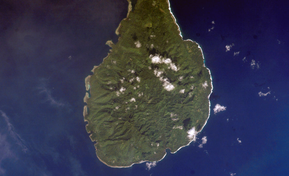
Tabar Island is the main island of the Tabar Islands and forms part of the New Ireland Province. It is located approximately 900 km north east of Port Moresby and about 24 km northeast of the province's main island New Ireland.
The island is of volcanic origin and has an area of about 110 km2 with a length of about 20 km and about 9 km wide. The highest altitude is approximately 400 m above sea level. Tabar Island is the largest and southernmost island in the archipelago.
The population is mainly divided into a few villages along the coast and the island's interior is covered mostly by rainforest. The main town of Datava is located on the island's northern part at Koko Bay .
The islands can only be reached by ship as they do not have an airport, the neighboring Tatau Island is on the other side of the barely distant canal that separates the islands.
History
The island has probably been inhabited by melanesians since about 1500 BC. It was charted by Dutch captains Jacob Le Maire and Willem Corneliszoon Schouten in June 1616 and then named "Gardner Islands". They were later visited by Abel Tasman who then dubbed the area to the "Visser Islands".
The area came under German sovereignty in 1885 as part of German New Guinea. The area was managed initially by the German New Guinea Company.
After the First World War, the area ended up under Australian control, and Australia later became officially mandated for the entire Bismarck Archipelago by the United Nations.
From 1942 to 1945, the area was occupied by Japan, but returned to the Australian government mandate until Papua New Guinea became independent in 1975.
Carl Emil Pettersson, a Swedish sailor who was shipwrecked and landed on the island in 1904, became its king (nicknamed "Strong Charly") after his marriage to the daughter of a local chief after he passed.[2]
References
- Slone, Thomas H. (1 September 2001). One Thousand One Papua New Guinean Nights: Folktales from Wantok Newspapers: Volume 1 Tales from 1972-1985. Masalai Press. p. 148. ISBN 978-0-9714127-0-5. Retrieved 31 December 2012.
- Weidermann, Volker (16 May 2004). "Pippi Langstrumpfs Vater: Knallkuß aus einer fernen Welt". Frankfurter Allgemeine Zeitung (in German). Retrieved 22 January 2013.
This Papua New Guinea–related geography article is a stub. You can help Wikipedia by expanding it. |
На других языках
[de] Tabar (Insel)
Tabar ist eine Insel, die zu den Tabar-Inseln in der Provinz New Ireland von Papua-Neuguinea gehört. Sie ist die Hauptinsel der Gruppe und wird von dem Volksstamm der Tabar bewohnt.[1] Administrativ ist die Insel Teil des Distrikts Namatanai. Die etwa 100 Quadratkilometer große Insel liegt 25 km nordöstlich von Neuirland, der Hauptinsel der Provinz. Die Insel ist vulkanischen Ursprung, etwa 9 km breit, 20 km lang und überwiegend von Flachland mit andesitischen Erhebungen von über 400 m und gehobenen Korallenkalken geprägt.[2]- [en] Tabar Island
[it] Tabar (isola)
Tabar (nota anche come Grande Tabar) è un'isola di Papua Nuova Guinea.Другой контент может иметь иную лицензию. Перед использованием материалов сайта WikiSort.org внимательно изучите правила лицензирования конкретных элементов наполнения сайта.
WikiSort.org - проект по пересортировке и дополнению контента Википедии