geo.wikisort.org - Island
Normanby Island is a volcanic 1,000-square-kilometre (390 sq mi), L-shaped island, the southernmost island in the D'Entrecasteaux Islands group. It is part of Milne Bay Province, Papua New Guinea.
This article does not cite any sources. (December 2009) |
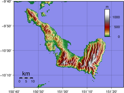 Topographic map of Normanby Island | |
 Normanby | |
| Geography | |
|---|---|
| Coordinates | 10°S 151°E |
| Archipelago | D'Entrecasteaux Islands |
| Area | 1,000 km2 (390 sq mi) |
| Highest elevation | 1,158 m (3799 ft) |
| Highest point | Prevost Range |
| Administration | |
Papua New Guinea | |
| Province | Milne Bay Province |
| Largest settlement | Esa’ala |
Normanby Island is 16 km (10 mi) north-east of East Cape, on the island of New Guinea, separated by Goschen Strait, and is separated by the Dawson Strait (Dobu Passage) from Fergusson Island. The island rises to 1,158 m (3,799 ft) in the Prevost Range in the southeast. The terrain includes low coastal plains and swamplands, high mountains and steep coastal slopes. Sewa Bay provides shelter on the west coast and Awaiara (Sewataitai) Bay on the east coast. The largest settlement, and district headquarters, is Esa’ala at the island's northern end.
In 1873, the island was visited by British Captain John Moresby, commanding HMS Basilisk, who named it after the Marquess of Normanby, George Augustus Constantine Phipps, a governor of Queensland, Australia.
Once known to produce gold, Normanby now exports copra and some timber. Recent discoveries of gold deposits are beginning to be exploited.
This article about an island in Papua New Guinea is a stub. You can help Wikipedia by expanding it. |
На других языках
[de] Normanby
Normanby, einheimischer Name Duau, ist eine vulkanische, etwa 850 km² große, L-förmige Insel im Pazifischen Ozean. Sie ist die südlichste der D’Entrecasteaux-Inseln, die zur Milne Bay Province in Papua-Neuguinea gehören.- [en] Normanby Island (Papua New Guinea)
[fr] Normanby (Papouasie-Nouvelle-Guinée)
Normanby est une île de la province de Baie Milne en Papouasie-Nouvelle-Guinée.[it] Normanby
Normanby è un'isola d'origine vulcanica di Papua Nuova Guinea.[ru] Норманби
Остров Норманби (англ. Normanby Island), иногда Остров Дуау (англ. Duau Island) — вулканический остров в Соломоновом море. Является частью архипелага Д’Антркасто, принадлежащего Папуа — Новой Гвинее. Остров вытянут в длину в направлении северо-запад — юго-восток на 73 км, при ширине 4 — 28 км. Площадь острова — 1040 км². От ближайших островов отделён проливами Доусон (3 км до острова Фергуссон) и Гошен (18 км до острова Новая Гвинея). Административно относятся к провинции Милн-Бей региона Папуа. Главным населённым пунктом острова является Еса'ала.Другой контент может иметь иную лицензию. Перед использованием материалов сайта WikiSort.org внимательно изучите правила лицензирования конкретных элементов наполнения сайта.
WikiSort.org - проект по пересортировке и дополнению контента Википедии