geo.wikisort.org - Island
Makada is island in Duke of York Islands archipelago in Papua New Guinea.[1] It is located in the east of the country, in the East New Britain Province, about 800 km to the east of the Port Moresby.
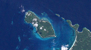 Makada island in the Duke of York Islands group. NASA Landsat 7 image, 2000. | |
 Makada | |
| Geography | |
|---|---|
| Location | Oceania |
| Coordinates | 4°07′S 152°25′E |
| Archipelago | Duke of York Islands |
| Total islands | 13 |
| Major islands | Duke of York Island, Papua New Guinea |
| Area | 3.6 km2 (1.4 sq mi) |
| Highest point | 122 |
| Administration | |
Geography
The land of Makada Island is flat. The highest point on the island is 122 meters above sea level. It covers about 2.7 km from the north to the south and 3.0 km from the east to the west. It covers about 3.6 square kilometers.
References
- Makada Island: Papua New Guinea National Geospatial-Intelligence Agency, Bethesda, MD, USA
This Papua New Guinea–related geography article is a stub. You can help Wikipedia by expanding it. |
Текст в блоке "Читать" взят с сайта "Википедия" и доступен по лицензии Creative Commons Attribution-ShareAlike; в отдельных случаях могут действовать дополнительные условия.
Другой контент может иметь иную лицензию. Перед использованием материалов сайта WikiSort.org внимательно изучите правила лицензирования конкретных элементов наполнения сайта.
Другой контент может иметь иную лицензию. Перед использованием материалов сайта WikiSort.org внимательно изучите правила лицензирования конкретных элементов наполнения сайта.
2019-2026
WikiSort.org - проект по пересортировке и дополнению контента Википедии
WikiSort.org - проект по пересортировке и дополнению контента Википедии