geo.wikisort.org - Island
Kiwai Island is the largest island in the Fly River delta, Papua New Guinea. It is one of the Torres Strait Islands. It is 59 km long along the northwest–southeast axis from Wamimuba Point in the northwest to the village of Saguane (Sanguane) in the south, and up to 9 km wide, with an average width of 5.6 km. Its area is 359 km2.[1] Neighboring Purutu and Wabuda Islands to the north and northeast are also among the three largest islands in the Fly River delta. A language study mentioned a population of about 4500,[2] but the census of population of 2000 showed only 2092 inhabitants.
This article uses bare URLs, which are uninformative and vulnerable to link rot. (August 2022) |
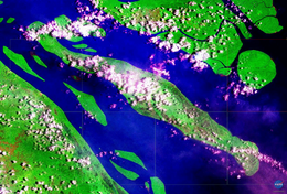 NASA satellite image (Geocover 2000) | |
 Kiwai Island | |
| Geography | |
|---|---|
| Location | Fly River |
| Coordinates | 8°33′S 143°25′E |
| Archipelago | Fly River Delta Islands |
| Major islands | Kiwai, Purutu, Wabuda Island |
| Area | 359.1 km2 (138.6 sq mi) |
| Length | 59 km (36.7 mi) |
| Width | 9 km (5.6 mi) |
| Coastline | 135.3 km (84.07 mi) |
| Highest point | unnamed |
| Administration | |
Papua New Guinea | |
| Province | Western Province |
| District | South Fly District |
| LLG | Kiwai Rural |
| Largest settlement | Iasa |
| Demographics | |
| Population | 2092 (2000) |
| Ethnic groups | Kiwai |
The island separates the north and south entrances of the Fly River. It is well wooded and only a few feet above water. The chief village, Iasa, is located on the south side of the island. Sumai village is on the same side of the island and 24 km farther northwest. Doropo village is about midway along the north side of the island. At the east end of the island are other small villages, such as Sagasia, Ipisia, Agobara and Oromosapuo.
The inhabitants of the Fly River delta engage in agriculture and hunting. Coconut palm, breadfruit, plantain, sago palm, and sugar cane are grown.[3]
Administratively, the island is part of Kiwai Rural LLG (Local Level Government area) of South Fly District, Western Province.

See also
- Kiwai language
- Kiwaian languages
- Kiwai Rural LLG
 New Guinea portal
References
This article about an island in Papua New Guinea is a stub. You can help Wikipedia by expanding it. |
На других языках
[de] Kiwai (Insel)
Kiwai ist eine Binneninsel und die größte Insel im Delta des Flusses Fly, Papua-Neuguinea. Sie ist 59 km lang vom Dorf Sepe an der Nordspitze bis zum Dorf Samari an der Südspitze, bis zu neun Kilometer breit, hat einen Umfang von 135,3 km und eine Fläche von 359,1 km².[1] Eine sprachliche Studie gab eine Bevölkerung von 4500 für die Insel an,[2] die Volkszählung 2000 wies jedoch nur 2.092 Einwohner nach.[3] Die benachbarten Inseln Purutu und Wabuda gehören ebenfalls zu den drei größten Inseln im Fly-Flussdelta.- [en] Kiwai Island
[fr] Kiwai
Kiwai est une île de Papouasie-Nouvelle-Guinée, située sur la côte du golfe de Papouasie, au sud de l'île de Nouvelle-Guinée.[it] Kiwai
L'isola di Kiwai è un'isola della Papua Nuova Guinea, ed è la più grande fra quelle che si trovano alla foce del fiume Fly nel sud della Nuova Guinea. Amministrativamente fa parte del Distretto di South Fly nella Provincia Occidentale, appartenente alla Regione di Papua.[ru] Киваи
Киваи (англ. Kiwai Island) — крупнейший остров в дельте реки Флай (Папуа — Новая Гвинея). В административном отношении относится к округу Саут-Флай Западной провинции страны. Протянулся на 59 км с северо-запада на юго-восток при максимальной ширине 9 км и средней ширине — всего 5,6 км. Площадь острова составляет 359,1 км².[1] Другие крупные острова дельты реки Флай — Пуруту и Вабуда, расположены к северу и северо-востоку от Киваи. Население острова по данным переписи 2000 года — 2092 человека.Другой контент может иметь иную лицензию. Перед использованием материалов сайта WikiSort.org внимательно изучите правила лицензирования конкретных элементов наполнения сайта.
WikiSort.org - проект по пересортировке и дополнению контента Википедии