geo.wikisort.org - Island
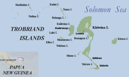
Kitava is one of the four major islands in the Trobriand Islands archipelago group of the Solomon Sea, located in Milne Bay Province of southeastern Papua New Guinea.
 | |
| Geography | |
|---|---|
| Location | Solomon Sea |
| Coordinates | 8°37′20″S 151°20′04″E |
| Archipelago | Trobriand Islands |
| Adjacent bodies of water | Pacific Ocean |
| Major islands | Kitava, Kiriwina, Kaileuna, Vakuta |
| Administration | |
Papua New Guinea | |
| Province | Milne Bay Province |
| Additional information | |
| Time zone |
|
Ethnography
The inhabitants of this island and their lifestyle and nearly exclusively plant-based diet have been the subject of study by researcher Staffan Lindeberg and his colleagues, due to their reported excellent health and traditional diet. Lindeberg et al. have published several works in peer-reviewed journals outlining their discoveries.[1]
See also
- Trobriand Islands topics
Notes
- "TheKitavaStudy". Staffanlindeberg.com. Archived from the original on 2013-12-07. Retrieved 2013-12-07.
References
| Authority control |
|
|---|
This Milne Bay Province geography article is a stub. You can help Wikipedia by expanding it. |
На других языках
[de] Kitava
Kitava ist die östlichste Insel der Trobriand-Inseln in Papua-Neuguinea. Sie liegt 17,8 km östlich der Hauptinsel Kiriwina. Gut 300 Meter westlich der Westspitze ist die unbewohnte und nur rund vier Hektar große Nebeninsel Uratu vorgelagert.- [en] Kitava
Текст в блоке "Читать" взят с сайта "Википедия" и доступен по лицензии Creative Commons Attribution-ShareAlike; в отдельных случаях могут действовать дополнительные условия.
Другой контент может иметь иную лицензию. Перед использованием материалов сайта WikiSort.org внимательно изучите правила лицензирования конкретных элементов наполнения сайта.
Другой контент может иметь иную лицензию. Перед использованием материалов сайта WikiSort.org внимательно изучите правила лицензирования конкретных элементов наполнения сайта.
2019-2026
WikiSort.org - проект по пересортировке и дополнению контента Википедии
WikiSort.org - проект по пересортировке и дополнению контента Википедии