geo.wikisort.org - Island
Irai Island is the main island of the Conflict Islands, which were sighted in 1879 by HMS Cormorant and named in 1880 by Bower, captain of HMS Conflict.[3]
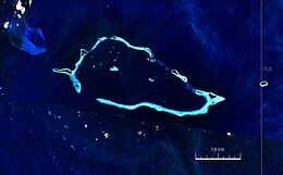
 Satellite image | |
 | |
 Irai Island 10°46′03″S 151°41′33″E | |
| Geography | |
|---|---|
| Location | Oceania |
| Coordinates | 10°46′03″S 151°41′33″E[1] |
| Archipelago | Louisiade Archipelago |
| Adjacent bodies of water | Solomon Sea |
| Total islands | 1 |
| Major islands |
|
| Area | 1.08 km2 (0.42 sq mi) |
| Length | 6 km (3.7 mi) |
| Width | 0.25 km (0.155 mi) |
| Administration | |
Papua New Guinea | |
| Province | |
| District | Samarai-Murua District |
| LLG[2] | Bwanabwana Rural LLG |
| Island Group | Calvados Chain |
| Largest settlement | Copra Plantation (pop. 20) |
| Demographics | |
| Population | 20 (2014) |
| Pop. density | 18.5/km2 (47.9/sq mi) |
| Ethnic groups | Papauans, Austronesians, Melanesians. |
| Additional information | |
| Time zone |
|
| ISO code | PG-MBA |
| Official website | www |
References
- Prostar Sailing Directions 2004 New Guinea Enroute, p. 168
- LLG map
- Arthur Wichman (Hrsg.): History of New-Guinea (bis 1828). Bd. 1, E. J. Brill, Leiden 1909, S. 271
Текст в блоке "Читать" взят с сайта "Википедия" и доступен по лицензии Creative Commons Attribution-ShareAlike; в отдельных случаях могут действовать дополнительные условия.
Другой контент может иметь иную лицензию. Перед использованием материалов сайта WikiSort.org внимательно изучите правила лицензирования конкретных элементов наполнения сайта.
Другой контент может иметь иную лицензию. Перед использованием материалов сайта WikiSort.org внимательно изучите правила лицензирования конкретных элементов наполнения сайта.
2019-2025
WikiSort.org - проект по пересортировке и дополнению контента Википедии
WikiSort.org - проект по пересортировке и дополнению контента Википедии