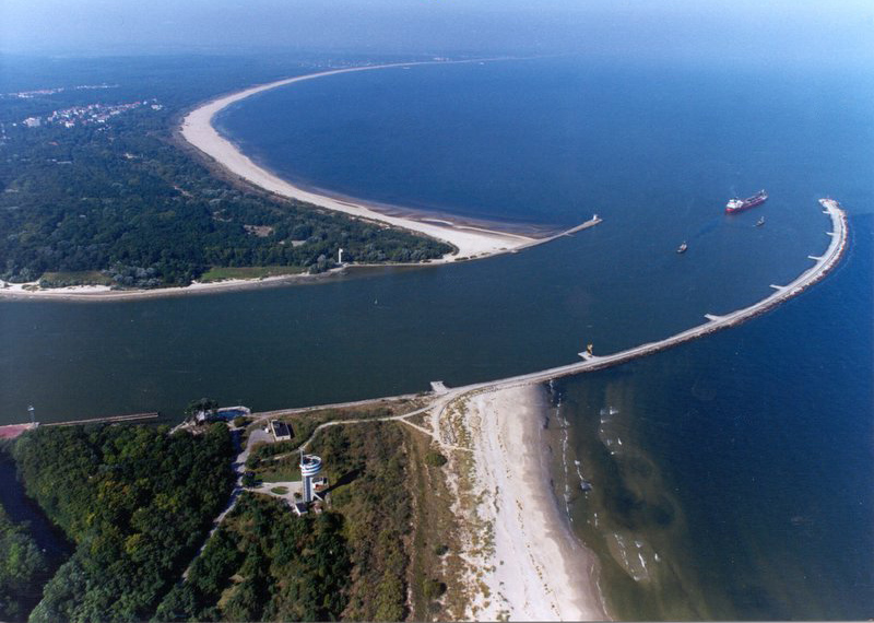
geo.wikisort.org - River The Świna (German : Swine ; Pomeranian : Swina ) is a channel in northwest Poland, between 2 and 4 km from the German border. It flows from Szczecin Lagoon to the Baltic Sea between the islands of Uznam and Wolin . It is a part of the Oder estuary, and carries about 75% of that river's waterflow (of the remainder, Peenestrom carries 15% and Dziwna 10%). It has a length of about 16 km. Świnoujście is a major town on the channel.
Landsat satellite photo showing Świna and the Piast canal to the west of it River in Poland
The German Empire dammed and deepened the straits from 1874-1880 to create the Kaiserfahrt (Piast canal).[1] Szczecin Lagoon and the Pomeranian harbor of Szczecin (Stettin). The straits thus gained importance as a direct waterway to the industrial city. The territory along the straits' path was transferred from Germany to Poland following World War II.
Regressive Delta
The regressive delta was formed by the floods of Świna channel in the area of the Wolin National Park in 1996. This water-muddy natural complex forms an archipelago of 44 islands and canals with changing directions of water flow. The Delta Świna channel was formed by the Scandinavian glacier that withdrew from this territory 12 thousand years ago. During the western and northern storms sea water flowed into Szczecin Lagoon , overflowing the islands. The borders of islands are constantly shaped during the process of accumulation.
References
See also
Main tributaries of the left bank Main tributaries of the right bank Distributary Cities
Geography of Pomerania
Regions
Current
Western Pomerania
Farther Pomerania
Pomerelia
Former
Circipania
Lauenburg and Bütow Land
Lands of Schlawe and Stolp
Administration Towns and cities
Towns
List of towns in Western Pomerania
List of towns in Farther Pomerania
List of placenames in the Province of Pomerania
Cities
with powiat rights other electing a city mayorPolish : prezydent miasta ) district-belonging German : Große kreisangehörige Städte )
Inhabited islands Peninsulae and headlands Rivers Lakes Bays, lagoons National parks
Western Pomerania Lagoon Area
Jasmund
Lower Oder Valley
Wolin
Drawa
Słowiński
Bory Tucholskie
History of Pomerania
10,000 BC – 600 AD
600– 1100
1100– 1300
1300– 1500
1500– 1806
1806– 1933
1933– 1945
1945– present
Administrative
Western Pomerania
Billung March
Northern March
Principality of Rügen
Duchy of Pomerania
House of Pomerania
List of Dukes
Gützkow
Partitions
Pomerania-Demmin
Pomerania-Stettin
Pomerania-Schlawe
Pomerania-Wolgast
Pomerania-Stolp
Pomerania-Neustettin
Pomerania-Stargard
Pomerania-Rügenwalde
Pomerania-Wolgast-Stolp
Pomerania-Barth
Swedish Pomerania
Province of Pomerania 1815– 1945
Stettin Region
Stralsund Region
List of placenames
Enclave of Police
Szczecin Voivodeship 1946–1975
Mecklenburg-Vorpommern 1946–1952
Bezirk Frankfurt Bezirk Neubrandenburg Bezirk Rostock
Szczecin Voivodeship 1975–1998
Contemporary
Farther Pomerania
Duchy of Pomerania
House of Pomerania
List of Dukes
Cammin
Schlawe-Stolp
Partitions
Pomerania-Stolp
Brandenburgian Pomerania (Draheim)
Province of Pomerania 1815– 1945
Stettin Region
Köslin Region
List of placenames
Szczecin Voivodeship 1946–1975
Koszalin Voivodeship 1950–1975
Szczecin Voivodeship 1975–1998
Koszalin Voivodeship 1975–1998
Słupsk Voivodeship 1975–1998
Contemporary
Lauenburg-Bütow classified asPomerelia
Duchy of Pomerania
House of Pomerania
List of Dukes
Partitions
Royal Prussia
Lauenburg-Bütow Pawn
Brandenburgian Pomerania
Province of Pomerania 1815–1945
Szczecin Voivodeship 1946–1975
Koszalin Voivodeship 1950–1975
Słupsk Voivodeship 1975–1998
Contemporary
Pomerelia (Kashubia , Chełmno Land )
Polish Pomerelia Danish Pomerelia Duchy of Pomerelia
Duchy of Gdańsk
Duchy of Świecie and Lubiszewo
Duchy of Białogarda
Duchy of Lubiszewo
Duchy of Świecie
State of the Teutonic Order
Royal Prussia 1466–1793
Pomeranian Voivodeship
Chełmno Voivodeship
Free City of Danzig 1807–1814
West Prussia
Posen-West Prussia Region
Pomeranian Voivodeship 1919– 1939 (Polish Corridor)
Free City of Danzig 1920– 1939
Reichsgau Danzig-West Prussia
Gdańsk Voivodeship 1946–1975
Bydgoszcz Voivodeship 1946–1975
Szczecin Voivodeship 1946–1975
Koszalin Voivodeship 1950–1975
Gdańsk Voivodeship 1975–1998
Koszalin Voivodeship 1975–1998
Słupsk Voivodeship 1975–1998
Bydgoszcz Voivodeship 1975–1998
Toruń Voivodeship 1975–1998
Contemporary
Ecclesiastical
Roman Catholic
Historical
Christianization of Pomerania Diocese of Wollin/Cammin
Diocese of Kolberg
Diocese of Chełmno
Diocese of Roskilde
Apostolic Vicariate of Northern Germany
Prince-Episcopal Delegation for Brandenburg and Pomerania
Apostolic Administration of the Free City of Danzig
Apostolic Administration of Tütz
Prelature of Schneidemühl
Apostolic Administration of Kamień (Cammin), Lubusz (Lebus) and the Prelature of Piła (Schneidemühl) with see in Gorzów Wielkopolski 1945–1972 Extant
Archdiocese of Berlin
Diocese of Bydgoszcz
Archdiocese of Gdańsk
Diocese of Koszalin-Kołobrzeg
Diocese of Pelplin
Archdiocese of Szczecin-Kamień
Diocese of Toruń
Diocese of Włocławek
Protestant
Historical
Evangelical State Church in Prussia
Pomeranian Evangelical Church Extant
Evangelical Church in Germany
Evangelical Lutheran Church in Northern Germany
Lutheran Diocese of Mecklenburg and Pomerania
Evangelical Reformed Church in Germany
Evangelical Church of the Augsburg Confession in Poland
Lutheran Diocese of Pomerania-Greater Poland
Lutheran Diocese of Wrocław
Pentecostal Church in Poland
Demography and anthropology
Archaeological cultures
Hamburg
Maglemosian
Ertebølle-Ellerbek
Linear Pottery
Funnelbeaker
Havelland
Corded Ware
Comb Ceramic
Nordic Bronze Age
Lusatian
Jastorf
Pomeranian
Oksywie
Wielbark
Gustow
Dębczyn (Denzin) Peoples
Gepids Goths
Lemovii
Rugii
Vidivarii
Vistula Veneti
Slavic Pomeranians
Prissani
Rani
Ukrani
Veleti
Lutici
Velunzani
German Pomeranians
Kashubians
Poles
Slovincians Major demographic events
Migration Period
Ostsiedlung WWII flight and expulsion of Germans
Post-WWII settlement of Poles and Ukrainians Languages and dialects
Treaties
1200– 1500
Kremmen (1236)
Landin (1250)
Kępno (1282)
Soldin (1309)
Templin (1317)
Ueckermünde (1327)Kalisz (1343)
Stralsund (1354)
Stralsund (1370)
Pyzdry (1390)
Raciążek (1404)
Thorn, First (1411)
Eberswalde, First (1415)Melno (1422)
Perleberg (1427)Eberswalde, Second (1427)Łęczyca (1433)
Brześć Kujawski (1435)
Soldin (1466)
Thorn, Second (1466)
Prenzlau (1448/1468/1472/1479)
Pyritz (1493) 1500– 1700
Thorn (1521)
Kraków (1525)
Grimnitz (1529)
Augsburg (1555)
Lublin (1569)
Stettin (1570)
Franzburg (1627)
Stettin (1630)
Westphalia (1648)
Stettin (1653)
Labiau (1656)
Wehlau and Bromberg (1657)
Oliva (1660)
Saint-Germain-en-Laye (1679)
Lund (1679) 1700– present
Stockholm (1719 / 1720)
Frederiksborg (1720)
Polish Partitions Treaties (1772/1773, 1793, 1795)
Tilsit (1807)
Kiel (1814)
Vienna (1815)
North German Confederation Treaty (1866)
Peace of Prague (1866)
Versailles (1919)
Polish Concordat (1925)
Prussian Concordat (1929)
Reichskonkordat (1933)
Molotov–Ribbentrop (1939)
Potsdam (1945)
Zgorzelec (1951)
Moscow (1970)
Warsaw (1970)
Helsinki Accords (1975)
Polish-East German Maritime Border Agreement (1989)Two Plus Four (1990)
German Reunification Treaty (1990)
German–Polish Border Treaty (1991)
Treaty of Good Neighbourship (1991)
Polish Concordat (1993)
Convention on the International Commission on the Protection of the Oder against Pollution (1996)Treaty of Accession 2003
На других языках - [en] Świna [it] Świna Lo Świna (pronuncia [ɕfiːna], in tedesco Swine, in casciubo Swina) è un fiume della Polonia nord-occidentale, nel voivodato della Pomerania Occidentale, che scorre dalla laguna di Stettino alla baia della Pomerania, nel mar Baltico, dividendo le isole di Wolin e Usedom[1]. [ru] Свина (река, впадает в Поморскую бухту) Свина (польск. Świna, нем. Swine) — река в Западно-Поморском воеводстве Польши, разделяющая острова Узедом и Волин и соединяющая Щецинскую лагуну с Померанской бухтой. Является частью эстуария Одры (через Свину в море попадает до 75 % одерской воды). В случае сильных ветров с Балтийского моря направление течения Свины меняется, и уже не речная вода поступает в море, а морская вода поступает в Щецинскую лагуну. Длина Свины составляет около 16 км, ширина от 100 до 1000 метров[1]. Текст в блоке "Читать" взят с сайта "Википедия" и доступен по лицензии Creative Commons Attribution-ShareAlike ; в отдельных случаях могут действовать дополнительные условия. 2019-2026