geo.wikisort.org - River The Peene (German: [ˈpeːnə] (listen ) is a river in Germany.
River in Germany
For other uses, see Peene (disambiguation).
This article needs additional citations for verification . (December 2009 )
Peene Peene river, its affluents, and Peenestrom strait
Country Germany State Mecklenburg-Vorpommern Cities Demmin , Anklam Source Westpeene • locationVollrathsruhe • elevation30 m (98 ft)
2nd source Ostpeene • locationSchloen • elevation80 m (260 ft)
3rd source Kleine Peene (Teterower Peene) • locationGroß Wokern • elevation85 m (279 ft)
Mouth Peenestrom • location
Anklam • coordinates
53°51′46″N 13°48′52″E • elevation
0 m (0 ft) Length 138.5 km (86.1 mi) Basin size 5,110 km2 (1,970 sq mi) Discharge • average20.6 m3 /s (730 cu ft/s)
Tributaries • leftTrebel • rightTollense
Geography
The Westpeene , with the Ostpeene as its longer tributary, and the Kleine Peene /Teterower Peene (with a Peene without specification (or Nordpeene ) as its smaller and shorter affluent) flows into Kummerower See (Lake Kummerow), and from there as Peene proper to Anklam and into the Oder Lagoon.
The western branch of the Oder River, which separates the island of Usedom from the German mainland, is often also called Peene, but actually is considered a part of the Baltic Sea called the Peenestrom . It is one of three channels connecting the Oder Lagoon with the Bay of Pomerania of the Baltic Sea . (The other channels are the Świna and the Dziwna.)
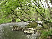
Ostpeene
Old watermill on Kleine Peene in
Teterow Peenestrom strait with
Wolgast Peenestrom harbour in
Wolgast
Longitudinal profile of Peene river from Malchin to the mouth into Peenestrom Hydrography
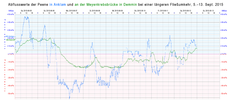
The Peene river itself has some properties of an inlet. From Kummerower See, inclusively, to the mouth, the ground of the water is five feet and more below sea level. The windkessel effect of the large surface of this lake allows reverse flows that with northern wind may last as long as a week. These reverse flows do not only occur in times of low discharge of its effluent, but also in times of an overflow of precipitation.
Water levels at a series of gauges on Peene river and Peenestrom strait during a week of revers flows. Karlshagen is on Peenestrom, near the open sea. Aalbude is near the exit of lake Kummerow. Coloured backgrounds represent stituations, when a more seaward waterlevel was higher than a more inland water level Flows in Anklam and in Demmin during the same week. The lower part of this graphic (with red grid )shows reverse flows. Ecology
The Peene Valley is one of the largest contiguous fen regions in central Europe.[1] Amazon of the North".[2]
Major towns at the Peene river are Malchin , Teterow , Demmin and Anklam .
Wolgast is on Peenestrom strait.
References
External links
Geography of Pomerania
Regions
Current
Western Pomerania
Farther Pomerania
Pomerelia
Gdańsk Pomerania
Kashubia
Kociewie
Tuchola Forest
Chełmno Land
Michałów Land
Lubawa Land Former
Circipania
Lauenburg and Bütow Land
Lands of Schlawe and Stolp
Administration
Mecklenburg-Vorpommern
Brandenburg
West Pomeranian Voivodeship
Pomeranian Voivodeship
Kuyavian-Pomeranian Voivodeship
Pomerania Euroregion Towns and cities
Towns
List of towns in Western Pomerania
List of towns in Farther Pomerania
List of placenames in the Province of Pomerania
Cities
with powiat rights
Tricity
Szczecin
Toruń
Koszalin
Grudziądz
Słupsk
Świnoujście other electing a city mayorPolish : prezydent miasta )
Stargard
Tczew
Wejherowo
Kołobrzeg
Starogard Gdański district-belonging German : Große kreisangehörige Städte )
Inhabited islands Peninsulae and headlands Rivers Lakes Bays, lagoons National parks
Western Pomerania Lagoon Area
Jasmund
Lower Oder Valley
Wolin
Drawa
Słowiński
Bory Tucholskie
History of Pomerania
10,000 BC – 600 AD
600– 1100
1100– 1300
1300– 1500
1500– 1806
1806– 1933
1933– 1945
1945– present
Administrative
Western Pomerania
Billung March
Northern March
Principality of Rügen
Duchy of Pomerania
House of Pomerania
List of Dukes
Gützkow
Partitions
Pomerania-Demmin
Pomerania-Stettin
Pomerania-Schlawe
Pomerania-Wolgast
Pomerania-Stolp
Pomerania-Neustettin
Pomerania-Stargard
Pomerania-Rügenwalde
Pomerania-Wolgast-Stolp
Pomerania-Barth
Swedish Pomerania
Province of Pomerania 1815– 1945
Stettin Region
Stralsund Region
List of placenames
Enclave of Police
Szczecin Voivodeship 1946–1975
Mecklenburg-Vorpommern 1946–1952
Bezirk Frankfurt Bezirk Neubrandenburg Bezirk Rostock
Szczecin Voivodeship 1975–1998
Contemporary
Mecklenburg-Vorpommern
Brandenburg
West Pomeranian Voivodeship Farther Pomerania
Duchy of Pomerania
House of Pomerania
List of Dukes
Cammin
Schlawe-Stolp
Partitions
Pomerania-Stolp
Brandenburgian Pomerania (Draheim)
Province of Pomerania 1815– 1945
Stettin Region
Köslin Region
List of placenames
Szczecin Voivodeship 1946–1975
Koszalin Voivodeship 1950–1975
Szczecin Voivodeship 1975–1998
Koszalin Voivodeship 1975–1998
Słupsk Voivodeship 1975-1998
Contemporary
West Pomeranian Voivodeship
Pomeranian Voivodeship Lauenburg-Bütow classified as
Duchy of Pomerania
House of Pomerania
List of Dukes
Partitions
Royal Prussia
Lauenburg-Bütow Pawn
Brandenburgian Pomerania
Province of Pomerania 1815–1945
Szczecin Voivodeship 1946–1975
Koszalin Voivodeship 1950–1975
Słupsk Voivodeship 1975-1998
Contemporary
Pomerelia (Kashubia,
Polish Pomerelia
Danish Pomerelia
Duchy of Pomerelia
Duchy of Gdańsk
Duchy of Świecie and Lubiszewo
Duchy of Białogarda
Duchy of Lubiszewo
Duchy of Świecie
State of the Teutonic Order
Royal Prussia 1466–1793
Pomeranian Voivodeship
Chełmno Voivodeship
Free City of Danzig 1807–1814
West Prussia
Posen-West Prussia Region
Pomeranian Voivodeship 1919– 1939 (Polish Corridor)
Free City of Danzig 1920– 1939
Reichsgau Danzig-West Prussia
Gdańsk Voivodeship 1946–1975
Bydgoszcz Voivodeship 1946–1975
Szczecin Voivodeship 1946–1975
Koszalin Voivodeship 1950–1975
Gdańsk Voivodeship 1975–1998
Koszalin Voivodeship 1975–1998
Słupsk Voivodeship 1975–1998
Bydgoszcz Voivodeship 1975–1998
Toruń Voivodeship 1975–1998
Contemporary
Pomeranian Voivodeship
West Pomeranian Voivodeship
Kuyavian-Pomeranian Voivodeship
Ecclesiastical
Roman Catholic
Historical
Christianization of Pomerania Diocese of Wollin/Cammin
Diocese of Kolberg
Diocese of Chełmno
Diocese of Roskilde
Apostolic Vicariate of Northern Germany
Prince-Episcopal Delegation for Brandenburg and Pomerania
Apostolic Administration of the Free City of Danzig
Apostolic Administration of Tütz
Prelature of Schneidemühl
Apostolic Administration of Kamień (Cammin), Lubusz (Lebus) and the Prelature of Piła (Schneidemühl) with see in Gorzów Wielkopolski 1945-1972 Extant
Archdiocese of Berlin
Diocese of Bydgoszcz
Archdiocese of Gdańsk
Diocese of Koszalin-Kołobrzeg
Diocese of Pelplin
Archdiocese of Szczecin-Kamień
Diocese of Toruń
Diocese of Włocławek
Protestant
Historical
Evangelical State Church in Prussia
Pomeranian Evangelical Church Extant
Evangelical Church in Germany
Evangelical Lutheran Church in Northern Germany
Lutheran Diocese of Mecklenburg and Pomerania
Evangelical Reformed Church in Germany
Evangelical Church of the Augsburg Confession in Poland
Lutheran Diocese of Pomerania-Greater Poland
Lutheran Diocese of Wrocław
Pentecostal Church in Poland
Demography and anthropology
Archaeological cultures
Hamburg
Maglemosian
Ertebølle-Ellerbek
Linear Pottery
Funnelbeaker
Havelland
Corded Ware
Comb Ceramic
Nordic Bronze Age
Lusatian
Jastorf
Pomeranian
Oksywie
Wielbark
Gustow
Dębczyn (Denzin) Peoples
Gepids Goths
Lemovii
Rugii
Vidivarii
Vistula Veneti
Slavic Pomeranians
Prissani
Rani
Ukrani
Veleti
Lutici
Velunzani
German Pomeranians
Kashubians
Poles
Slovincians Major demographic events
Migration Period
Ostsiedlung WWII flight and expulsion of Germans
Post-WWII settlement of Poles and Ukrainians Languages and dialects
Treaties
1200– 1500
Kremmen (1236)
Landin (1250)
Kępno (1282)
Soldin (1309)
Templin (1317)
Ueckermünde (1327)Kalisz (1343)
Stralsund (1354)
Stralsund (1370)
Pyzdry (1390)
Raciążek (1404)
Thorn, First (1411)
Eberswalde, First (1415)Melno (1422)
Perleberg (1427)Eberswalde, Second (1427)Łęczyca (1433)
Brześć Kujawski (1435)
Soldin (1466)
Thorn, Second (1466)
Prenzlau (1448/1468/1472/1479)
Pyritz (1493) 1500– 1700
Thorn (1521)
Kraków (1525)
Grimnitz (1529)
Augsburg (1555)
Lublin (1569)
Stettin (1570)
Franzburg (1627)
Stettin (1630)
Westphalia (1648)
Stettin (1653)
Labiau (1656)
Wehlau and Bromberg (1657)
Oliva (1660)
Saint-Germain-en-Laye (1679)
Lund (1679) 1700– present
Stockholm (1719 / 1720)
Frederiksborg (1720)
Polish Partitions Treaties (1772/1773, 1793, 1795)
Tilsit (1807)
Kiel (1814)
Vienna (1815)
North German Confederation Treaty (1866)
Peace of Prague (1866)
Versailles (1919)
Polish Concordat (1925)
Prussian Concordat (1929)
Reichskonkordat (1933)
Molotov–Ribbentrop (1939)
Potsdam (1945)
Zgorzelec (1951)
Moscow (1970)
Warsaw (1970)
Helsinki Accords (1975)
Polish-East German Maritime Border Agreement (1989)Two Plus Four (1990)
German Reunification Treaty (1990)
German–Polish Border Treaty (1991)
Treaty of Good Neighbourship (1991)
Polish Concordat (1993)
Convention on the International Commission on the Protection of the Oder against Pollution (1996)Treaty of Accession 2003
Authority control
General National libraries
На других языках [de] Peene Die Peene ist ein Küstenfluss in Mecklenburg-Vorpommern. Sie ist der siebtgrößte Meereszufluss mit Einzugsgebiet in Deutschland (nach der Ems). Der Name stammt aus dem Slawischen: Pěna und bedeutet „Schaum“, bzw. „der schaumige (Fluss)“.[3] - [en] Peene [it] Peene Il Peene è un fiume che scorre nella Germania nord-orientale, precisamente nello Stato del Meclemburgo-Pomerania Anteriore. Il suo nome ha origine slava e significa corso d'acqua. Esso sfocia, nei pressi della città di Anklam, nel cosiddetto Peenestrom.[1] [ru] Пене Пе́не[1] (нем. Peene) — река в Германии, в земле Мекленбург-Передняя Померания. Вместе с реками Вестпене и Остпене впадает в озеро Куммеровер-Зе, а оттуда в качестве Пены вытекает и несёт воды в направлении города Анклама и к Щецинскому заливу. Текст в блоке "Читать" взят с сайта "Википедия" и доступен по лицензии Creative Commons Attribution-ShareAlike ; в отдельных случаях могут действовать дополнительные условия. 2019-2026


 Ostpeene
 Old watermill on Kleine Peene in Teterow
 Peene harbour in Demmin
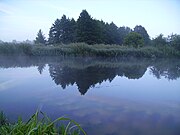 Peene river near Loitz
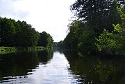 Peene river near Jarmen
 Peene river in Anklam
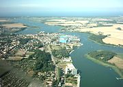 Peenestrom strait with Wolgast
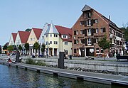 Peenestrom harbour in Wolgast


 Media related to Peene at Wikimedia Commons