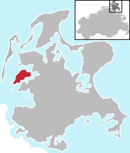
geo.wikisort.org - Island The island of Ummanz lies in the Baltic Sea , off the west coast of the island of Rügen , and belongs, like the latter, to the county of Vorpommern-Rügen in the German state of Mecklenburg-Western Pomerania.
Ummanz St. Mary's Church, Waase
Location Baltic Sea Coordinates 54°28′27″N 13°10′24″E Area 20 km2 (7.7 sq mi) Highest elevation 3 m (10 ft) Germany
Largest settlement Waase Population 274
Slab track on Ummanz Ummanz is around 20 square kilometres in area and thus, after Rügen, the second largest island in the former county of Rügen. It is part of the Western Pomerania Lagoon Area National Park. The island is bounded to the west and northwest by the Schaproder Bodden, to the north, by the inlet of Udarser Wiek, to the east by the lake of Koselower See and the Breite and to the south by the Kubitzer Bodden. The island of Ummanz is very flat; its highest point lying just 3 metres above sea level (NN).
Since 1901 the island has been linked to the island of Rügen by a 250-metre-long bridge. The largest settlement on the island is the parish village of Waase ; other villages are Haide, Markow, Suhrendorf, Freesenort, Tankow and Wusse. Together with several villages on Rügen itself it forms the municipality of Ummanz .
From 1341 the island was owned by the Heiliggeisthospital at Stralsund . As a result, Stralsund's citizens exercised lordship over the island for centuries on behalf of the church foundation.
External links
Wikimedia Commons has media related to
Ummanz .
Denmark Estonia Finland Germany Poland Russia Sweden
German Baltic Sea islands
Geography of Pomerania
Regions
Current
Western Pomerania
Farther Pomerania
Pomerelia
Gdańsk Pomerania
Kashubia
Kociewie
Tuchola Forest
Chełmno Land
Michałów Land
Lubawa Land Former
Circipania
Lauenburg and Bütow Land
Lands of Schlawe and Stolp
Administration
Mecklenburg-Vorpommern
Brandenburg
West Pomeranian Voivodeship
Pomeranian Voivodeship
Kuyavian-Pomeranian Voivodeship
Pomerania Euroregion Towns and cities
Towns
List of towns in Western Pomerania
List of towns in Farther Pomerania
List of placenames in the Province of Pomerania
Cities
with powiat rights
Tricity metro
Szczecin
Toruń
Koszalin
Grudziądz
Słupsk
Świnoujście other electing a city mayorPolish : prezydent miasta ) district-belonging German : Große kreisangehörige Städte )
Inhabited islands Peninsulae and headlands Rivers Lakes Bays, lagoons National parks
Western Pomerania Lagoon Area
Jasmund
Lower Oder Valley
Wolin
Drawa
Słowiński
Bory Tucholskie
History of Pomerania
10,000 BC – 600 AD
600– 1100
1100– 1300
1300– 1500
1500– 1806
1806– 1933
1933– 1945
1945– present
Administrative
Western Pomerania
Billung March
Northern March
Principality of Rügen
Duchy of Pomerania
House of Pomerania
List of Dukes
Gützkow
Partitions
Pomerania-Demmin
Pomerania-Stettin
Pomerania-Schlawe
Pomerania-Wolgast
Pomerania-Stolp
Pomerania-Neustettin
Pomerania-Stargard
Pomerania-Rügenwalde
Pomerania-Wolgast-Stolp
Pomerania-Barth
Swedish Pomerania
Province of Pomerania 1815– 1945
Stettin Region
Stralsund Region
List of placenames
Enclave of Police
Szczecin Voivodeship 1946–1975
Mecklenburg-Vorpommern 1946–1952
Bezirk Frankfurt Bezirk Neubrandenburg
Bezirk Rostock
Szczecin Voivodeship 1975–1998
Contemporary
Mecklenburg-Vorpommern
Brandenburg
West Pomeranian Voivodeship Farther Pomerania
Duchy of Pomerania
House of Pomerania
List of Dukes
Cammin
Schlawe-Stolp
Partitions
Pomerania-Stolp
Brandenburgian Pomerania (Draheim)
Province of Pomerania 1815– 1945
Stettin Region
Köslin Region
List of placenames
Szczecin Voivodeship 1946–1975
Koszalin Voivodeship 1950–1975
Szczecin Voivodeship 1975–1998
Koszalin Voivodeship 1975–1998
Słupsk Voivodeship 1975-1998
Contemporary
West Pomeranian Voivodeship
Pomeranian Voivodeship Lauenburg-Bütow classified as
Duchy of Pomerania
House of Pomerania
List of Dukes
Partitions
Royal Prussia
Lauenburg-Bütow Pawn
Brandenburgian Pomerania
Province of Pomerania 1815–1945
Szczecin Voivodeship 1946–1975
Koszalin Voivodeship 1950–1975
Słupsk Voivodeship 1975-1998
Contemporary
Pomerelia (Kashubia,
Polish Pomerelia
Danish Pomerelia
Duchy of Pomerelia
Duchy of Gdańsk
Duchy of Świecie and Lubiszewo
Duchy of Białogarda
Duchy of Lubiszewo
Duchy of Świecie
State of the Teutonic Order
Royal Prussia 1466–1793
Pomeranian Voivodeship
Chełmno Voivodeship
Free City of Danzig 1807–1814
West Prussia
Posen-West Prussia Region
Pomeranian Voivodeship 1919– 1939 (Polish Corridor)
Free City of Danzig 1920– 1939
Reichsgau Danzig-West Prussia
Gdańsk Voivodeship 1946–1975
Bydgoszcz Voivodeship 1946–1975
Szczecin Voivodeship 1946–1975
Koszalin Voivodeship 1950–1975
Gdańsk Voivodeship 1975–1998
Koszalin Voivodeship 1975–1998
Słupsk Voivodeship 1975–1998
Bydgoszcz Voivodeship 1975–1998
Toruń Voivodeship 1975–1998
Contemporary
Pomeranian Voivodeship
West Pomeranian Voivodeship
Kuyavian-Pomeranian Voivodeship
Ecclesiastical
Roman Catholic
Historical
Christianization of Pomerania Diocese of Wollin/Cammin
Diocese of Kolberg
Diocese of Chełmno
Diocese of Roskilde
Apostolic Vicariate of Northern Germany
Prince-Episcopal Delegation for Brandenburg and Pomerania
Apostolic Administration of the Free City of Danzig
Apostolic Administration of Tütz
Prelature of Schneidemühl
Apostolic Administration of Kamień (Cammin), Lubusz (Lebus) and the Prelature of Piła (Schneidemühl) with see in Gorzów Wielkopolski 1945-1972 Extant
Archdiocese of Berlin
Diocese of Bydgoszcz
Archdiocese of Gdańsk
Diocese of Koszalin-Kołobrzeg
Diocese of Pelplin
Archdiocese of Szczecin-Kamień
Diocese of Toruń
Diocese of Włocławek
Protestant
Historical
Evangelical State Church in Prussia
Pomeranian Evangelical Church Extant
Evangelical Church in Germany
Evangelical Lutheran Church in Northern Germany
Lutheran Diocese of Mecklenburg and Pomerania
Evangelical Reformed Church in Germany
Evangelical Church of the Augsburg Confession in Poland
Lutheran Diocese of Pomerania-Greater Poland
Lutheran Diocese of Wrocław
Pentecostal Church in Poland
Demography and anthropology
Archaeological cultures
Hamburg
Maglemosian
Ertebølle-Ellerbek
Linear Pottery
Funnelbeaker
Havelland
Corded Ware
Comb Ceramic
Nordic Bronze Age
Lusatian
Jastorf
Pomeranian
Oksywie
Wielbark
Gustow
Dębczyn (Denzin) Peoples
Gepids Goths
Lemovii
Rugii
Vidivarii
Vistula Veneti
Slavic Pomeranians
Prissani
Rani
Ukrani
Veleti
Lutici
Velunzani
German Pomeranians
Kashubians
Poles
Slovincians Major demographic events
Migration Period
Ostsiedlung WWII flight and expulsion of Germans
Post-WWII settlement of Poles and Ukrainians Languages and dialects
Treaties
1200– 1500
Kremmen (1236)
Landin (1250)
Kępno (1282)
Soldin (1309)
Templin (1317)
Ueckermünde (1327)Kalisz (1343)
Stralsund (1354)
Stralsund (1370)
Pyzdry (1390)
Raciążek (1404)
Thorn, First (1411)
Eberswalde, First (1415)Melno (1422)
Perleberg (1427)Eberswalde, Second (1427)Łęczyca (1433)
Brześć Kujawski (1435)
Soldin (1466)
Thorn, Second (1466)
Prenzlau (1448/1468/1472/1479)
Pyritz (1493) 1500– 1700
Thorn (1521)
Kraków (1525)
Grimnitz (1529)
Augsburg (1555)
Lublin (1569)
Stettin (1570)
Franzburg (1627)
Stettin (1630)
Westphalia (1648)
Stettin (1653)
Labiau (1656)
Wehlau and Bromberg (1657)
Oliva (1660)
Saint-Germain-en-Laye (1679)
Lund (1679) 1700– present
Stockholm (1719 / 1720)
Frederiksborg (1720)
Polish Partitions Treaties (1772/1773, 1793, 1795)
Tilsit (1807)
Kiel (1814)
Vienna (1815)
North German Confederation Treaty (1866)
Peace of Prague (1866)
Versailles (1919)
Polish Concordat (1925)
Prussian Concordat (1929)
Reichskonkordat (1933)
Molotov–Ribbentrop (1939)
Potsdam (1945)
Zgorzelec (1951)
Moscow (1970)
Warsaw (1970)
Helsinki Accords (1975)
Polish-East German Maritime Border Agreement (1989)Two Plus Four (1990)
German Reunification Treaty (1990)
German–Polish Border Treaty (1991)
Treaty of Good Neighbourship (1991)
Polish Concordat (1993)
Convention on the International Commission on the Protection of the Oder against Pollution (1996)Treaty of Accession 2003
Authority control
General National libraries
На других языках [de] Ummanz Die Insel Ummanz liegt in der Ostsee, westlich vorgelagert vor der Insel Rügen und gehört wie diese zum Landkreis Vorpommern-Rügen im deutschen Bundesland Mecklenburg-Vorpommern. - [en] Ummanz [fr] Ummanz Ummanz est une île allemande de la mer Baltique. D'une superficie de 20 km2, elle est située à l'ouest de l'île de Rügen, à laquelle elle est reliée par un pont de 250 mètres de long depuis 1901. [it] Ummanz Ummanz (20 km² ca.) è un'isola tedesca sul Mar Baltico, appartenente al land Meclemburgo-Pomerania Anteriore (Mecklenburg-Vorpommern) e situata ad ovest dell'isola di Rügen (da cui è separata da un ponte, lungo appena 250 metri[1]) e a sud-est dell'isola di Hiddensee.
Parte dell'isola fa parte del Nationalpark Vorpommersche Boddenlandschaft. Amministrativamente l'isola appartiene invece al comune omonimo del Circondario di Rügen, che comprende anche una porzione della costa occidentale dell'isola di Rügen. Текст в блоке "Читать" взят с сайта "Википедия" и доступен по лицензии Creative Commons Attribution-ShareAlike ; в отдельных случаях могут действовать дополнительные условия. 2019-2026