geo.wikisort.org - Island
Muhu (also called Muhumaa in Estonian), is an island in the West Estonian archipelago of the Baltic Sea. With an area of 198 km2 (76 sq mi) it is the third largest island belonging to Estonia, after Saaremaa and Hiiumaa.
This article does not cite any sources. (February 2022) |
 | |
| Geography | |
|---|---|
| Location | Baltic Sea |
| Coordinates | 58°35′46″N 23°14′16″E |
| Archipelago | West Estonian archipelago |
| Area | 198 km2 (76 sq mi) |
| Administration | |
Estonia | |
| Saare County | |
| Demographics | |
| Population | 1,968 (2010) |
| Pop. density | 8.8/km2 (22.8/sq mi) |
| Ethnic groups | Majority Estonians |
Together with neighbouring smaller islands of Kesselaid, Viirelaid, Võilaid and Suurlaid it forms Muhu Parish (Estonian: Muhu vald), the rural municipality within Saare County. The municipality has a population of 1,697 (as of 19 April 2010) and covers an area of 206.12 km2 (80 sq mi). The population density is 8.8/km2 (23/sq mi).
History and geography
The German names for the island are Mohn and Moon. Moon is also the Swedish name for the island.
The most important villages in Muhu are Kuivastu, Liiva (where the school can be found) and Koguva. In Pädaste, an internationally renowned luxury hotel and spa operates in the restored manor house.
The island is divided from mainland Estonia by the Suur Strait (Moonsund) and from Saaremaa by the Väike Strait. It is linked by ferry to Virtsu in the mainland, and to Saaremaa by a causeway, the Väinatamm. In winter an ice road connects the island to the mainland.
In January 1227, an army of the Livonian Brothers of the Sword with Letts, Germans of Riga and native Livonians (20,000 men commanded by William of Modena) crossed on sea ice from the mainland and attacked the island of Saaremaa to reduce the last holdout of pagan Estonians. The Estonians surrendered on Muhu at a circular stronghold called Mona, the earthworks of which are still preserved near the causeway between the islands. This ended the Estonian Crusade.
The Battle of Karuse or Battle on the Ice was fought on 16 February 1270 between the Grand Duchy of Lithuania and the Livonian Order on the frozen Baltic Sea between the Muhu Island and the mainland. The Lithuanians achieved a decisive victory. The battle, named after the Karuse village, was the fifth-largest defeat of the Livonian or Teutonic Orders in the 13th century.[citation needed]
The same waters saw the Battle of Moon Sound in September–October 1917 between Russian and German naval forces.
Muhu is also famous for having the only still-working traditional windmills in Estonia.
Muhu is the home of Estonia's first wine tourism farm – Luscher & Matiesen Muhu Winehouse.
Gallery
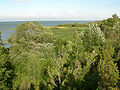 Northern coast of Muhu
 Muhu Stronghold, site of the native Estonian surrender to crusaders in 1227
 Monument in the center of the Muhu Stronghold
 Üügu cliffs
 Muhu St. Catherine's Church
 Pädaste Manor
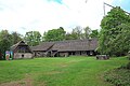 Tooma farm, part of Muhu museum and birthplace of writer Juhan Smuul
 Students and teachers in traditional clothing march in a procession in Liiva
 Old village school
 In Mõega village
 Koguva harbour
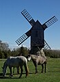 Windmill in Koguva
 Flag of Muhu Parish
 Coat of Arms of Muhu Parish


See also
- Municipalities of Estonia
- List of municipalities of Estonia
- List of islands of Estonia
External links
 Media related to Muhu at Wikimedia Commons
- Official website
- Muhu Tourism Association
- Muhu Island in Jetsetter Top10
- Photos about Muhu.
| Rural municipality |
| |
|---|---|---|
| Authority control: National libraries |
|---|
На других языках
[de] Muhu
Muhu (deutsch Moon oder Mohn, schwedisch Moon) ist die drittgrößte Insel Estlands. Sie gehört zu den Moonsund-Inseln.- [en] Muhu
[es] Muhu
Muhu es la tercera isla más grande en superficie de cuantas pertenecen a Estonia. La isla se encuentra localizada en la parte norte del golfo de Riga, separando el golfo del mar Báltico, entre la isla de Saaremaa y la Estonia continental. Administrativamente, Muhu constituye un municipio propio, que pertenece al condado de Saare. La isla ocupa una superficie de 206,1 km² y alberga una población de 1.803 habitantes (2005). Las coordenadas de Muhu son: 58°36′8″N 23°14′41″E.[fr] Muhu
Muhu, aussi appelée Muhumaa, est une île estonienne de l'archipel de Moonsund dans la mer Baltique.[ru] Муху
Му́ху (также известен как Моон, Мухумаа; эст. Muhu) — третий по величине остров Эстонии после Сааремаа и Хийумаа общей площадью 204 км²[1][2]. Является частью Моонзундского архипелага Балтийского моря.Другой контент может иметь иную лицензию. Перед использованием материалов сайта WikiSort.org внимательно изучите правила лицензирования конкретных элементов наполнения сайта.
WikiSort.org - проект по пересортировке и дополнению контента Википедии