geo.wikisort.org - Reservoir
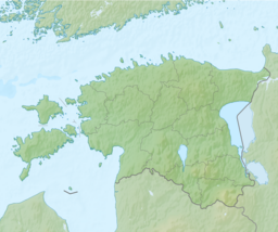
Lake Peipus[1] (Estonian: Peipsi-Pihkva järv; Russian: Чудско-Псковское озеро, Псковско-Чудское озеро, romanized: Chudsko-Pskovskoye ozero, Pskovsko-Chudskoye ozero); is the largest trans-boundary lake in Europe, lying on the border between Estonia and Russia.
| Lake Peipus | |
|---|---|
 Landsat satellite photo | |
 Lake Peipus 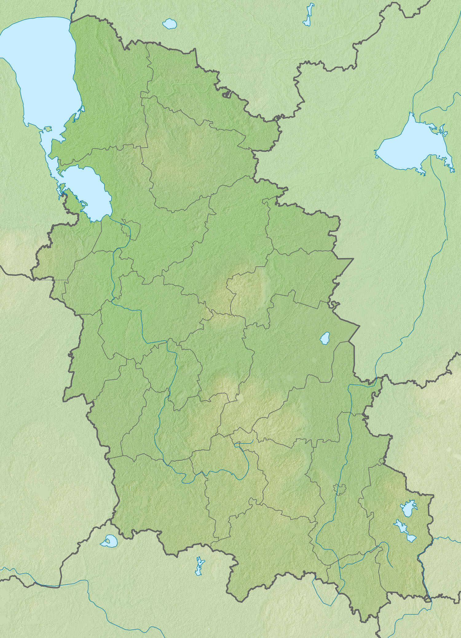 Lake Peipus  Lake Peipus | |
| Location | Estonia, Russia |
| Coordinates | 58°41′N 27°29′E |
| Native name | |
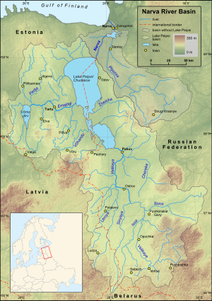
| Primary inflows | Emajõgi, Velikaya |
| Primary outflows | Narva |
| Catchment area | 47,800 km2 (18,500 sq mi) |
| Basin countries | Estonia, Latvia, and Russia |
| Surface area | 3,555 km2 (1,373 sq mi) |
| Average depth | 7.1 m (23 ft) |
| Max. depth | 15.3 m (50 ft) |
| Water volume | 25 km3 (6.0 cu mi) |
| Shore length1 | 520 km (320 mi) |
| Surface elevation | 30 m (98 ft) |
| Islands | Kamenka, Kolpina, Piirissaar |
| Settlements | Kallaste, Mustvee |
| 1 Shore length is not a well-defined measure. | |
The lake is the fifth-largest in Europe after Lake Ladoga and Lake Onega (in Russia north of Saint Petersburg), Lake Vänern (in Sweden), and Lake Saimaa (in Finland).[2]
The lake is a remnant of water regularly collecting at the foot of large, perennial arctic ice sheets during recent ice ages. It covers 3,555 km2 (1,373 sq mi), and has an average depth of 7.1 m (23 ft), the deepest point being 15 m (49 ft).[3][4] The lake has several islands and consists of three parts:
- Lake Peipsi / Chudskoye (Estonian: Peipsi järv, Russian: Чудское озеро), the northern part of the lake, with an area of 2,611 km2 (1,008 sq mi) (73%)
- Lake Pihkva / Pskovskoye (Estonian: Pihkva järv, Russian: Псковское озеро), the southern part of the lake (area 708 km2 (273 sq mi) or 20%)
- Lake Lämmi / Tyoploye (Estonian: Lämmijärv, Russian: Тёплое озеро), the sound connecting the other two parts of the lake (area 236 km2 (91 sq mi) or 7%)
The lake is used for fishing and recreation, but suffered from environmental degradation from Soviet-era agriculture. Some 30 rivers and streams discharge into Lake Peipus. The largest rivers are the Emajõgi and the Velikaya. The lake drains into the Gulf of Finland via the river Narva.
In 1242 the lake was the site of the Battle on the Ice (Russian: Ледовое побоище; Estonian: Jäälahing) between the Teutonic Knights and Novgorodians under Prince Alexander Nevsky.
Formation
This section needs additional citations for verification. (August 2010) |
The lake is a remnant of a larger body of water which existed in this area during a former ice age.[5] In the Paleozoic Era, 300–400 million years ago, the entire territory of the modern Gulf of Finland was covered by a sea. Its modern relief was formed as a result of glacier activities, the last of which, the Weichselian glaciation, ended about 12,000 years ago.
Topography and hydrography
The banks of Lake Peipus have smooth contours and form only one large bay – Raskopelsky Bay. The low shores of the lake mostly consist of peat and are bordered by vast lowland and marshes, which are flooded in the spring with the flooding area reaching up to 1,000 km2 (390 sq mi).[6] There are sand dunes and hills covered with pine forests. Along the sandy shores, there is a 200–300 metres (660–980 ft) wide stretch of shallow waters.[7]
| Water balance | Volume | |
|---|---|---|
| Inflow | Precipitation | 560 mm (1.9 km3) |
| Surface and groundwater | 3150 mm (11.2 km3) | |
| Outflow | Streamflow | 3390 mm (12 km3) |
| Evaporation | 320 mm (1.1 km3) |
The relief of the bottom is uniform and flat, gradually rising near the shores and covered with silt, and in some places with sand.[8] The deepest point of 15.3 metres (50 ft) is located in the Teploe Lake, 300 metres (980 ft) from the coast.[9]
The lake is well-flowing, with the annual inflow of water equal to about half of the total water volume.[6]
The lake water is fresh, with a low transparency of about 2.5 metres (8 ft 2 in) due to plankton and suspended sediments caused by the river flow.[6] Water currents are weak 5–9 cm/s (2.0–3.5 in/s); they are induced by the wind and stop when it ceases. However, during the spring flood, there is a constant surface current from north to south.[8]
Because of the shallow depth, the lake quickly warms and cools. Water temperature reaches 25–26 °C (77–79 °F) in July.[9] The lakes freeze in late November – early December and thaw in late April – early May, first lakes Teploe and Pihkva and then lake Peipus. However, due to recent climatic changes, Lake Peipus has now commonly started to freeze later into December and thaw much earlier in April.[6]
 |
 |
 |
| Shoreline, south of Mustvee | Kallaste | Mustvee harbour |
Basin and islands
About 30 rivers flow into the lake.[10] The largest are Velikaya and Emajõgi; smaller rivers include Zadubka, Cherma, Gdovka, Kuna, Torokhovka, Remda, Rovya, Zhelcha, Chernaya, Lipenka, Startseva, Borovka, Abija, Obdeh, Piusa, Võhandu, Kodza, Kargaya, Omedu, Tagajõgi and Alajõgi. The lake is drained by only one river, the Narva, into the Baltic Sea.[3]
The lake contains 29 islands, with a total area of 25.8 km2, with 40 more islands located within the delta of the Velikaya River.[9] The islands are low wetlands, elevated above the lake surface on average by only 1–2 metres (3 ft 3 in – 6 ft 7 in) (maximum 4.5 metres (15 ft)) and therefore suffer from floods. The largest islands are Piirissaar (area 7.39 km2 (2.85 sq mi), located in the southern part of Lake Peipus), Kolpina (area 11 km2, in the Pihkva Lake) and Kamenka (area 6 km2). In the center of Pihkva Lake there is a group of Talabski Islands (Talabsk, Talabenets and Verkhniy).[11]
Flora and fauna
The lake hosts 54 species of coastal aquatic flora, including cane, calamus (Acorus calamus), bulrush, grass rush, lesser bulrush (Typha angustifolia) and water parsnip (Sium latifolium). Floating plants are rare and are of only three types: arrowhead, yellow water-lily and water knotweed.[12] The lake is home to perch, pike-perch, bream, roaches, whitefishes, smelt and other species of fish.[3] The wetlands of the coastal strip of the lake are important resting and feeding grounds for swans, geese and ducks migrating between the White Sea and Baltic Sea and western Europe.[8][13] Lake Peipsi is one of the main stopovers for Bewick's swan (Cygnus columbianus). The swans leave their breeding grounds in the Russian Arctic 1,600 kilometres (990 mi) away and the lake is the first stop for many. Bewick's rarely fly more than 1,900 kilometres (1,200 mi) without fueling so they are near to the limits of their endurance when they reach the lake.[14]
Ecology
The ecological condition of the lake basin is, in general, satisfactory – water is mostly of grades I and II (clean), and is of grade III in some rivers due to the high content of phosphorus. The water condition of the rivers has improved since 2001–2007, but there is an increase in population of blue-green algae. The main problem of Lake Peipus is its eutrophication.[15]
 European perch
 Carp bream
 Roach
Roach Pike-perch


Economy
The towns standing on the banks are relatively small and include Mustvee (population 1,610), Kallaste (population 1,260) and Gdov (population 4,400). The largest city, Pskov (population 202,000) stands on the river Velikaya, 10 kilometres (6.2 mi) from the lake.[7] Ship navigation is well developed and serves fishery, transport of goods and passengers and tourist tours.[13][16][17] The picturesque shores of the lake are a popular destination for tourism and recreation at several tourist camps and sanatoriums.[18][19][20]
History
In 1242, the southern part of Lake Peipus hosted a major historical battle where Teutonic Knights were defeated by Novgorod troops led by Alexander Nevsky. The battle is remarkable in that it was mostly fought on the frozen surface of the lake and is therefore called the Battle on the Ice.[21][22]
The largest city on the lake, Pskov, is also one of the oldest cities in Russia, known from at least 903 AD from a record in the Primary Chronicle of the Laurentian Codex.[23][24] The city had a certain measure of independence even though it was dominated by its neighbours - Novgorod, Lithuania and Muscovy - and eventually incorporated in the Russian state. Several historical buildings remain in the city, including Mirozhsky Monastery (1156, which contains famous frescoes of 14–17th centuries), Pskov Kremlin (14–17th centuries) with the five-domed Trinity Cathedral (1682–1699), churches of Ivanovo (until 1243), Snetogorsky monastery (13th century), Church of Basil (1413), Church of Cosmas and Damian (1462), Church of St. George (1494) and others.[25]
Gdov was founded in 1431 as a fortress and became a city in 1780;[26] the only remains of the historical Gdov Kremlin are three fortress walls.[27] Kallaste was founded in the 18th century by the Old Believers who had fled from the Novgorod area,[28][29] and there is still a functional Russian Orthodox Old-Rite Church in the town. Near Kallaste, there is one of the largest surfacings of Devonian sandstone with a length of 930 metres (3,050 ft) and a maximum height of 8 metres (26 ft), as well as several caves and one of the largest colonies of swallows in Estonia.[30]
 |
 |
| Mirozhsky Monastery | Pskov Kremlin |
References
- Lake Peipus. Encyclopædia Britannica online
- The whispering waters of Estonia – Visit Estonia
- Чудско-Псковское озеро, Great Soviet Encyclopedia
- (in Russian) Russian lakes with area of more than 350 km². (GIF table). Retrieved on 2012-01-21.
- Encyclopedic Dictionary of Geography: Geographical names – Moscow: Soviet Encyclopedia. 1983, p. 488.
- Sokolov AA Hydrography of the USSR L.: Gidrometeoizdat, 1952
- Tourist Encyclopedia. Peipsi-Pskov Lake. Outdoors.ru. Retrieved on 2012-01-21.
- study the situation of the ports on the Narva River Archived 2016-03-03 at the Wayback Machine. Arhiv.ivangorod.ru. Retrieved on 2012-01-21.
- lakes and rivers south of Estonia, the islands [dead link]
- By Peipus pond Archived 2016-03-04 at the Wayback Machine. Zachetka.ru. Retrieved on 2012-01-21.
- "Публичная кадастровая карта". pkk5.rosreestr.ru. Retrieved 2018-01-08.[permanent dead link]
- Fish and Lake Pskov region. Lakes. Pskovfish.ru. Retrieved on 19 February 2017.
- Tourist portal. Svali.ru (2008-01-28). Retrieved on 2012-01-21.
- Newth, Julia (November 2016). "Race against time". BBC Wildlife. 34 (12): 40–6.
- Minutes of the eleventh meeting of the Joint Russian-Estonian commission for the protection and rational use of transboundary waters [dead link]
- TrevelTurs. Peipsi-Pskov lake system Archived 2016-03-04 at the Wayback Machine. Traveltours.ru. Retrieved on 2012-01-21.
- Transport of Pskov Oblast. All-transport.info. Retrieved on 2012-01-21.
- Pskov region. Peipsi and Lake Pskov Archived 2018-02-05 at the Wayback Machine. noveltour.ru
- More and more foreigners resting on Lake Peipus. Megatis.ru (2002-08-08). Retrieved on 2012-01-21.
- Tourist Encyclopedia. Vladsc.narod.ru. Retrieved on 2012-01-21.
- Tony Jaques (2007). Dictionary of Battles and Sieges: F-O. Greenwood Publishing Group. p. 564. ISBN 0-313-33538-9.
- Toivo Miljan (2004). Historical dictionary of Estonia. Scarecrow Press. p. 299. ISBN 0-8108-4904-6.
- Псков, Great Soviet Encyclopedia
- Wladyslaw Duczko (2004). Viking Rus: studies on the presence of Scandinavians in Eastern Europe. BRILL. p. 114. ISBN 90-04-13874-9.
- ancient city of Pskov. Old-pskov.ru. Retrieved on 2012-01-21.
- Гдов, Great Soviet Encyclopedia
- My Gdov Archived 2016-03-03 at the Wayback Machine. mygdov.ru (in Russian)
- Kallaste. A bit of history. Moles.ee (2000-06-28). Retrieved on 2012-01-21.
- Old Believer community Kallaste. Starover.ee. Retrieved on 2012-01-21.
- Russian site about the city Kallaste. Kallaste.ucoz.org (2012-01-04). Retrieved on 2012-01-21.
External links
- 360° aerial panorama of Peipus and Piirissaar
- Peipsi Infokeskus Estonian tourist information website
- Settlements in the vicinity of Lake Peipsi Estonica
Authority control | |
|---|---|
| General |
|
| National libraries | |
На других языках
[de] Peipussee
Der Peipussee (estnisch Peipsi-Pihkva järv; russisch Псковско-Чудское озеро oder Чудско-Псковское озеро, Pskowsko-Tschudskoje osero oder Tschudsko-Pskowskoje osero, „Pskower-und-Tschuden-See“) ist ein zwischen Estland und Russland gelegenes Binnengewässer. Mit 3555 km² ist er ungefähr siebenmal so groß wie der Bodensee und steht unter den größten Seen Europas an fünfter Stelle – nach dem Ladoga- und dem Onegasee in Russland sowie dem schwedischen Vänern und dem finnischen Saimaa.- [en] Lake Peipus
[es] Lago Peipus
El lago Peipus (en estonio, Peipsi-Pihkva järv; en ruso, Псковско-Чудское озеро (Чудско-Псковское озеро, Chudsko-Pskóvskoie); en alemán, Peipussee) es un gran lago situado en la frontera entre Estonia y Rusia, en Europa del Este.[fr] Lac Peïpous
Le lac Peïpous ou lac des Tchoudes (en russe : Псковско-Чудское озеро, Чудско-Псковское озеро, Pskovsko-Tchoudskoïe ozero, Tchoudsko-Pskovskoïe ozero ; en estonien : Peipsi-Pihkva järv ; en allemand : Peipussee) est un vaste lac partagé entre l'Estonie et la Russie.[it] Lago dei Ciudi
Il lago dei Ciudi, noto anche come lago Peipsi o lago Peipus (in estone Peipsi-Pihkva järv, in russo Чудско-Псковское озеро [Čudsko-Pskovskoe ozero], in tedesco Peipussee) è un vasto lago (3.555 km²) situato al confine fra l'Estonia e la Russia.[ru] Чудско-Псковское озеро
Чу́дско-Пско́вское о́зеро[1] или Пско́вско-Чудско́е о́зеро[2] (эст. Peipsi-Pihkva järv, встречаются также названия Гдовское озеро, Псковское море, Пейпси от эст. Peipsi, Пейпус, Пейпус-озеро[3] от нем. Peipussee) — крупный озёрный комплекс на границе между Эстонией и Псковской и Ленинградской областями России. Относится к бассейну Балтийского моря Атлантического океана. Площадь водосборного бассейна — 56 100 км²[4].Другой контент может иметь иную лицензию. Перед использованием материалов сайта WikiSort.org внимательно изучите правила лицензирования конкретных элементов наполнения сайта.
WikiSort.org - проект по пересортировке и дополнению контента Википедии