geo.wikisort.org - River
The river Narva (Estonian: Narva jõgi; Russian: Нарва), formerly also Narova flows 77 kilometres (48 mi) north into the Baltic Sea and is the largest Estonian river by discharge. A similar length of land far to the south, together with it and a much longer intermediate lake, altogether forms the Estonia-Russia border.
| Narva | |
|---|---|
 The Narva flowing between Hermann Castle and Ivangorod Fortress | |
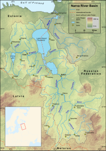 Map of the Narva and Lake Peipsi basins | |
| Native name | |
| Location | |
| Countries |
|
| Cities | |
| Physical characteristics | |
| Source | Lake Peipsi |
| • coordinates | 58°59′14″N 27°43′50″E |
| • elevation | 30 m (98 ft) |
| Mouth | Narva Bay in Finnish Gulf |
• coordinates | 59°28′14″N 28°02′37″E |
• elevation | 0 m (0 ft) |
| Length | 77 km (48 mi) |
| Basin size | 56,225 km2 (21,709 sq mi) |
| Discharge | |
| • average | 400 m3/s (14,000 cu ft/s) |
| Basin features | |
| Tributaries | |
| • left | Jaama, Poruni, Mustajõgi |
| • right | Plyussa, Rosson |
| Basin countries | Russia (62.9%), Estonia (30.5%), Latvia (6.6%),[1] Belarus (minute share)(see map) |
The long lake, mentioned, which the river drains is Lake Peipus. The lake notably drains the much longer Russian river, the Velikaya, and a large, splayed drainage basin in the two countries.
The river gives its name to the Narva culture and the city of Narva, which faces the Russian town Ivangorod.
At the coast it passes part of the resort of Narva-Jõesuu. Its mouth is specifically into the very open WNW-facing Narva Bay of the Gulf of Finland. It gives the second-greatest discharge into the Gulf of Finland. The greatest discharge is the Neva, ranking fourth as to European rivers.
Etymology

The etymology of the toponym Narva is not clear, but according to the most common theory it comes from a Vepsian word narva meaning waterfall or stream.[2]
Geography

The Narva river has its source at the northeastern end of Lake Peipus, near the villages of Vasknarva (Estonia) and Skyamya (Russia). There are a few more small villages on the upper section of the river, for example Permisküla and Kuningaküla on the Estonian side and Omuti on the Russian side, but up to the city of Narva the shores of the river are mostly forested or marshy land. The river is dammed entering Narva and Ivangorod, forming the Narva Reservoir, which extends up to 38 kilometres (24 mi) upstream.[3] The Narva empties into Narva Bay near the Estonian town of Narva-Jõesuu, third largest settlement on the river after Narva and Ivangorod.
The Plyussa is the largest tributary, joining the Narva at the Narva Reservoir from the right.
Waterfall
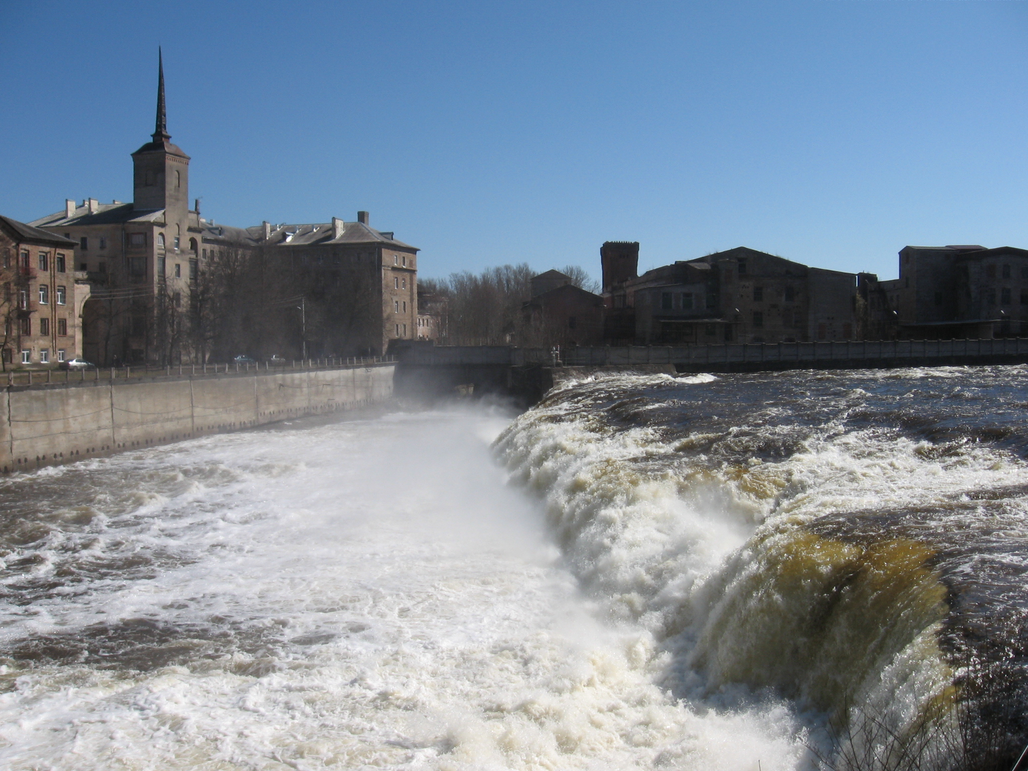
Between the southeast part of the city of Narva and the rest, facing the Russian city of Ivangorod, the river flows over the Baltic Klint, forming the Narva Waterfall, at times, as it historically was, the most powerful in Europe.[4] Before the water reaches the falls it is split into two branches by the Kreenholm island, thus the falls consist of two branches. Kreenholm Falls, west of the island, is 60 metres (200 ft) wide and 6.5 metres (21 ft) high with multiple terraces. Joala Falls, to the east, is 110 metres (360 ft) wide and makes the same descent. The international border follows the latter.[4]
Since the creation of Narva Reservoir, an anabranch, in 1955, the falls are usually near-dry, but water is allowed to flow in them for a few days each year. When in flow non-flying viewing access is difficult, being in the border zone and most of the west bank is private, closed industrial land belonging to Krenholm Manufacturing Company.
History
The Narva was used as a trade route during the Viking Age, from 5th to 11th century. It was an offshoot of the trade route from the Varangians to the Greeks.[5]
The Narva has for centuries been an important border river. Beginning in the 13th century it was the border of Medieval Livonia and the Novgorod Republic.[6] Though in earlier periods Narva was part of a larger buffer zone between the two territories, gradually the river emerged as the exact border.[6] Castles built on the river banks (Narva Hermann Castle, founded at the beginning of the 14th century, Ivangorod fortress, established in 1492 and Vasknarva Castle, first built in the 14th century) were one of the main reasons behind this. Treaties from the 15th century between the Livonian Order and Novgorod Republic, later Tsardom of Russia, also recognize the Narva as the border.[6] In XVII century during the time of Swedish Estonia, when Ingria was also part of Sweden, the importance of the river as a border diminished. During the Russian Empire, from the end of the Great Northern War until the establishment of the Republic of Estonia in 1918, the Narva was the border of Governorate of Estonia and Saint Petersburg Governorate, with the exception of the town of Narva, which was part of the latter. By the Treaty of Tartu, signed in 1920, the Estonian–Russian border went slightly east of the river, up to 10 kilometres (6 mi), and, in particular, the town of Ivangorod was assigned to Estonia. In 1944 the former Estonian territory east of the river was transferred to Russian SFSR and the Narva was thus established as the eastern border of Estonian SSR, an internal border within USSR. In 1991 the same border became the de facto border of Estonia and Russia. Although no official border treaty has been ratified since then,[7] today the Narva is the eastern border of the European Union and Schengen Zone.
Bridges

The Narva river is crossed only by a handful of bridges between Narva and Ivangorod. Besides the dam of the Narva Reservoir, these are, in downstream order:
- a pedestrian bridge below the Kreenholm island
- Narva Railway Bridge: Carrying the Tallinn–Saint Petersburg railway line.
- Friendship Bridge: The Tallinn–Saint Petersburg highway bridge on E20 just downstream from the Hermann Castle and Ivangorod Fortress. It was built in 1960 and is 162 metres (531 ft) long.
Bibliography
- Feršel, Anne-Ly (2010). The River Narva (PDF). Estonian Environmental Board. ISBN 978-9949-9057-4-4. Archived from the original (PDF) on 3 December 2013. Retrieved 2 August 2020.
References
- Nõges, Peeter; Järvet, Arvo (2005). "Climate driven changes in the spawning of roach and bream in the Estonian part of the Narva River basin" (PDF). Boreal Environment Research. 10.
- "Formation of city". Narva Museum. Retrieved 11 January 2009.
- "Sada aastat Narva jõe äravoolu mõõtmisi". Eesti Loodus (in Estonian). Retrieved 11 January 2009.
- Suuroja, Kalle (2005). Põhja-Eesti klint (in Estonian). Eesti Geoloogiakeskus. ISBN 9985-815-53-X.
- "Narva - History". Retrieved 13 February 2009.
- Selart, Anti (1996). "Narva jõgi - Virumaa idapiir keskajal". Akadeemia (in Estonian). 8 (12).
- "Russian-Estonian border agreement will be ratified". New Europe. 22 September 2007. Archived from the original on 22 July 2011. Retrieved 13 February 2009.
| Buildings and structures |
|
|---|---|
| Precincts |
|
| Nature and parks |
|
| Beaches |
|
| Cultural institutions |
|
| Science and education |
|
| Sports |
|
| Transportation |
|
| Authority control: National libraries |
|---|
На других языках
[de] Narva (Fluss)
Die Narva (estnisch Narva jõgi; russisch Нарва, deutsch Narwa) ist ein Fluss, der den etwa 77 Kilometer langen Abfluss des Peipussees zur Ostsee bildet. Sie beginnt bei dem Dorf Vasknarva und mündet bei der Stadt Narva-Jõesuu (deutsch: „Mündung der Narva“) in den Finnischen Meerbusen. Der Fluss ist schiffbar und speist den Narva-Stausee, an dem zu sowjetischer Zeit ein Kraftwerk zur Stromgewinnung errichtet wurde.- [en] Narva (river)
[es] Río Narva
El río Narva (en estonio Narva jõgi, en ruso река Нарва), es un corto río de Europa nororiental, que constituye la frontera natural septentrional entre Estonia y Rusia. El Narva, que es el río más caudaloso y ancho de Estonia, nace en el lago Peipus y discurre de sur a norte hasta llegar a la bahía de Narva, en el golfo de Finlandia. Tiene una longitud de solamente 77,75 km, pero con sus fuentes, el sistema Narva—lago Peipus-Pskov—río Velíkaya, alcanza los 647 km (77+140+430).[1][it] Narva (fiume)
Il Narva è il fiume più ampio dell'Estonia. Emissario del Lago Peipsi, scorre attraverso il contestato confine tra Estonia e Russia. Divide la città estone di Narva e quella russa di Ivangorod, unite fino al 1953 (anno in cui furono divise dai sovietici). Sfocia nei pressi di Narva-Jõesuu nel golfo della Narva, quest'ultimo parte del ben più ampio golfo di Finlandia, nel Mar Baltico.[ru] Нарва (река)
На́рва (Наро́ва[2]; эст. Narva jõgi и Naroova) — река на границе Эстонии и Ленинградской области Российской Федерации. В литературе также встречаются названия Алуксе (древнее название Наровы[3]) и Бек[4], последнее было употребимо во времена шведского владычества в XVII веке и упоминается у Олеария. На реке расположены города — российский Ивангород и эстонские Нарва и Нарва-Йыэсуу. Берега реки в настоящее время соединяют три моста. По фарватеру реки с 1991 года проходит российско-эстонская граница. Регион вдоль берегов реки носит название Принаровье.Другой контент может иметь иную лицензию. Перед использованием материалов сайта WikiSort.org внимательно изучите правила лицензирования конкретных элементов наполнения сайта.
WikiSort.org - проект по пересортировке и дополнению контента Википедии