geo.wikisort.org - River
The Songhua or Sunghwa River (also Haixi or Xingal, Russian: Сунгари Sungari) is one of the primary rivers of China, and the longest tributary of the Amur. It flows about 1,897 km (1,179 mi)[1] from the Changbai Mountains on the China–North Korea border through China's northeastern Jilin and Heilongjiang provinces.
| Songhua River | |
|---|---|
 Songhua River, just west of Harbin. Oxbow lakes are common sights along the sides of the river. | |
| Native name | |
| Location | |
| Country | People's Republic of China |
| Provinces | Jilin, Heilongjiang |
| Physical characteristics | |
| Mouth | Amur |
• location | Tongjiang, Heilongjiang |
• coordinates | 47.699°N 132.5176°E |
| Length | 1,897 km (1,179 mi)[1] |
| Basin size | 557,180 km2 (215,130 sq mi)[2] |
| Discharge | |
| • location | Tongjiang, China (near mouth) |
| • average | 76.2 km3/a (2,410 m3/s) to 81.77 km3/a (2,591 m3/s).[3][1] |
| Basin features | |
| Progression | Amur→ Sea of Okhotsk |
| Tributaries | |
| • left | Nen, Hulan, Tangwang |
| • right | Mudanjiang |
| Songhua River | |||||||
|---|---|---|---|---|---|---|---|
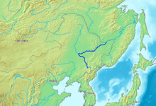 Songhua River is shown in a darkish blue color. | |||||||
| Chinese name | |||||||
| Chinese | 松花江 | ||||||
| |||||||
| Alternative Chinese name | |||||||
| Chinese | 海西 | ||||||
| |||||||
| Manchu name | |||||||
| Manchu script | ᠰᡠᠩᡤᠠᡵᡳ ᡠᠯᠠ | ||||||
| Romanization | sunggari ula | ||||||
The river drains 557,180 km2 (215,130 sq mi) of land, and has an annual discharge of 76.2 km3/a (2,410 m3/s) to 81.77 km3/a (2,591 m3/s).[4][1][5]
The extreme flatness of the Northeast China Plain has caused the river to meander over time, filling the wide plain with oxbow lakes, as remnants of the previous paths of the river.
Geography
The Songhua rises south of Heaven Lake, near the China-North Korea border.[citation needed]
From there it flows north, to be interrupted by the Baishan, Hongshi and Fengman hydroelectric dams. The Fengman Dam forms a lake that stretches for 62 kilometers (39 mi). Below the dam, the Second Songhua flows north through Jilin, then northwest until it is joined by its largest tributary, the Nen River, near Da'an, to create the Songhua proper.
The Songhua turns east through Harbin, and after the city, it is joined from the south by the Ashi River, and then by the Hulan River from the north.
A new dam was constructed in 2007 near Bayan (50 km northeast of Harbin), creating the Dadingshan Reservoir,[6] which is named after the scenic area on the south bank (Chinese: 大頂山; pinyin: dàdǐngshān; lit. 'Big Topped Mountain').
The river flows onward through Jiamusi and south of the Lesser Xing'an Range, to eventually join the Amur at Tongjiang, Heilongjiang.
The river freezes from late November until March. It has its highest flows when the mountain snow melts during the spring thaw. The river is navigable up to Harbin by medium-sized ships. Smaller craft can navigate the Songhua up to Jilin and the Nen River up to Qiqihar.
Cities along the river include:
History

In November 2005, the river was contaminated with benzene, leading to a shutdown of Harbin's water supply.[citation needed] The spill stretched 80 kilometers (50 mi) and eventually reached the Amur (Heilong) River on the China–Russia border.[7] On July 28, 2010, several thousand barrels from two chemical plants in China's Jilin City were washed away by floods. Some of them contained 170 kilograms (370 lb) of explosive material like trimethylsilyl chloride and hexamethyldisiloxane.[8][9] In 2016, the part near the city of Jilin was affected by a minor flood.
See also
- Geography of China
- Mudanjiang River
- "Along the Songhua River", a Chinese patriotic song
References
- Eugene A., Simonov; Thomas D., Dahmer. "Amur-Heilong River Basin Reader" (PDF). ISBN 9789881722713.
- ), National Geographic Society (U.S (2008). National Geographic Atlas of China, p. 36. ISBN 9781426201363.
{{cite book}}: CS1 maint: numeric names: authors list (link) - National Conditions: Main Rivers accessed October 21, 2010.
- National Conditions: Main Rivers accessed October 21, 2010.
- ), National Geographic Society (U.S (2008). National Geographic Atlas of China, p. 36. ISBN 9781426201363.
{{cite book}}: CS1 maint: numeric names: authors list (link) - "Dadingzishan reservoir – will it have a happy future?". Transrivers. China Daily. April 10, 2012. Retrieved October 17, 2019.
- China By Organisation for Economic Co-operation and Development, p.245. 2007. ISBN 9789264031159.
- Khabarovsk Region prevents poisoned Sungari water from reaching Amur, Jul 30, 2010, Moscow Time
- (in Russian)Defence lines were opened in attempt to intercept the barrels with chemicals, RIA Novosti, 30.07.2010
External links
Jilin topics | |
|---|---|
Changchun (capital) | |
| General | |
| Geography | |
| Education |
|
| Culture |
|
| Visitor attractions |
|
| |
Heilongjiang topics | |
|---|---|
Harbin (capital) | |
| General |
|
| Geography | |
| Education |
|
| Visitor attractions |
|
| |
Authority control | |
|---|---|
| General | |
| National libraries | |
На других языках
[de] Songhua Jiang
Der Songhua (chinesisch .mw-parser-output .Hani{font-size:110%}松花江, Pinyin Sōnghuā Jiāng, mandschurisch Sunggari ula, auch bekannt unter seinem russischen Namen Sungari, Сунгари) ist ein etwa 1927 km langer Fluss in China (Ostasien).- [en] Songhua River
[es] Río Songhua
Songhua léase Song-Júa (en chino, 松花江; pinyin, sōng hūa jīang) o Sunggari es un largo río asiático que discurre por el noreste de China, y es el mayor de los afluentes del río Amur (este último y literalmente, «río del Dragón Negro», en la provincia china de Heilongjiang). Tiene una longitud de 1927 km (que lo sitúan entre los 70 ríos más largos del mundo) y drena una gran cuenca de 549 090 km².[it] Songhua
Il Songhua (松花江S, SōnghuājiāngP; in russo: Сунгари?, Sungari) è un affluente di destra dell'Amur. Il suo corso è interamente contenuto nel territorio della Manciuria, nella Cina nord-orientale.[ru] Сунгари
До 1999 года также существовал округ Сунхуацзян, ныне — в составе города Харбин.Другой контент может иметь иную лицензию. Перед использованием материалов сайта WikiSort.org внимательно изучите правила лицензирования конкретных элементов наполнения сайта.
WikiSort.org - проект по пересортировке и дополнению контента Википедии