geo.wikisort.org - River
The Xiao River (Chinese: 瀟水; pinyin: Xiāoshuǐ [ɕjáʊ.ʂwèɪ]) is the Main Stream of the upper Xiang River located in Yongzhou, Hunan. As of 2011 Water Census of China, it has a length of 365 kilometres (227 mi) from the headwaters to the confluence in the Ping Island of Yongzhou with the Xiang River West Branch (Left Branch) originating from Guangxi. With the tributaries, its drainage basin area is 12,094 square kilometres (4,670 sq mi).[1]
| Xiao River Xiaoshui, Shenshui, Daqiao River, Feng River, Dong River, Tuojiang, etc. | |
|---|---|
 Picture of Xiao River in Yongzhou, Hunan, China. | |
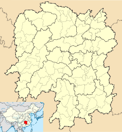 Location in Hunan | |
| Native name | 潇水 (Chinese) |
| Location | |
| Country | China |
| Province | Hunan |
| City | Yongzhou |
| Physical characteristics | |
| Source | |
| • location | Yegou Mountain (野狗岭) |
| Mouth | |
• location | Ping Island (萍岛) |
| Length | 365 km (227 mi) |
| Discharge | |
| • location | Yongzhou |
| • average | 345 m3/s (12,200 cu ft/s) |
| Basin features | |
| River system | Xiang River |
Geography
The Xiao River borders to the south by the Mengzhu Mountains and Gui River of Xi River tributary, to the east by Yangming Mountains (阳明山), Chongling River and Lianjiang River of Bei River tributary, to the west by the Dupang Mountains. The tributaries of the Xiao reach Lianzhou of Guangdong and Guangxi. Originating from the southern side of Yegou Mountain (野狗岭) in Zhulin Village (竹林村) of Xiangjiangyuan Township, Lanshan County, the Xiao River flows southwest to northeast through Lanshan, Jianghua, Jiangyong, Ningyuan, Dao, Shuangpai, Lengshuitan and Lingling eight counties, joining the Main Stem of the Xiang at the confluence in Ping Island of Yongzhou with the West Branch from Guangxi.[2]
See also
- List of rivers in China
- Xiaoxiang
- Hunan
References
- As of 2011 Water Census of China, the Xiao River was identified as the Main Stem of the Upper Xiang River. 湘江源头在湖南蓝山, 湘江干流全长948公里, 流域面积94,721平方公里 - The source stream of the Xiang is in Lanshan County, the main river of the Xiang has a length of 948 kilometres (589 mi) with a drainage basin area of rough 94,721 square kilometres (36,572 sq mi), according to hn.xinhuanet.com or rednet.cn (21-May-13)
- the river basin of the Xiao River, according to the Water Allocation Plans for Xiangjiang River Basin (湘江流域水量分配方案), also see 3y.uu456.com or wenku.baidu.com
This article related to a river in China is a stub. You can help Wikipedia by expanding it. |
На других языках
[de] Xiao Shui
Der Fluss Xiao Shui (潇水), bis zur Östlichen Jin-Dynastie (317–420) Ying Shui (营水),[3] ist ein Fluss im Süden der chinesischen Provinz Hunan. Er gilt seit 2013 als Oberlauf des Xiang Jiang,[2] der wiederum in den Dongting-See fließt und damit zum Flusssystem des Jangtsekiang gehört. Zusammen mit dem Xiang Jiang ist er Teil der Alternativbezeichnung „Xiaoxiang“ für die Provinz Hunan.- [en] Xiao River
Другой контент может иметь иную лицензию. Перед использованием материалов сайта WikiSort.org внимательно изучите правила лицензирования конкретных элементов наполнения сайта.
WikiSort.org - проект по пересортировке и дополнению контента Википедии