geo.wikisort.org - River
The River Exe (/ˈɛks/ EKS) in England rises at Exe Head, near the village of Simonsbath, on Exmoor in Somerset, 8.4 kilometres (5 mi) from the Bristol Channel coast, but flows more or less directly due south, so that most of its length lies in Devon. It flows for 60 miles (96 km)[1] and reaches the sea at a substantial ria, the Exe Estuary, on the south (English Channel) coast of Devon. Historically, its lowest bridging point was the Old Exe Bridge in Exeter, the largest settlement on the river, but there is now a viaduct for the M5 motorway about 3 kilometres (2 mi) south of the city centre.
| River Exe | |
|---|---|
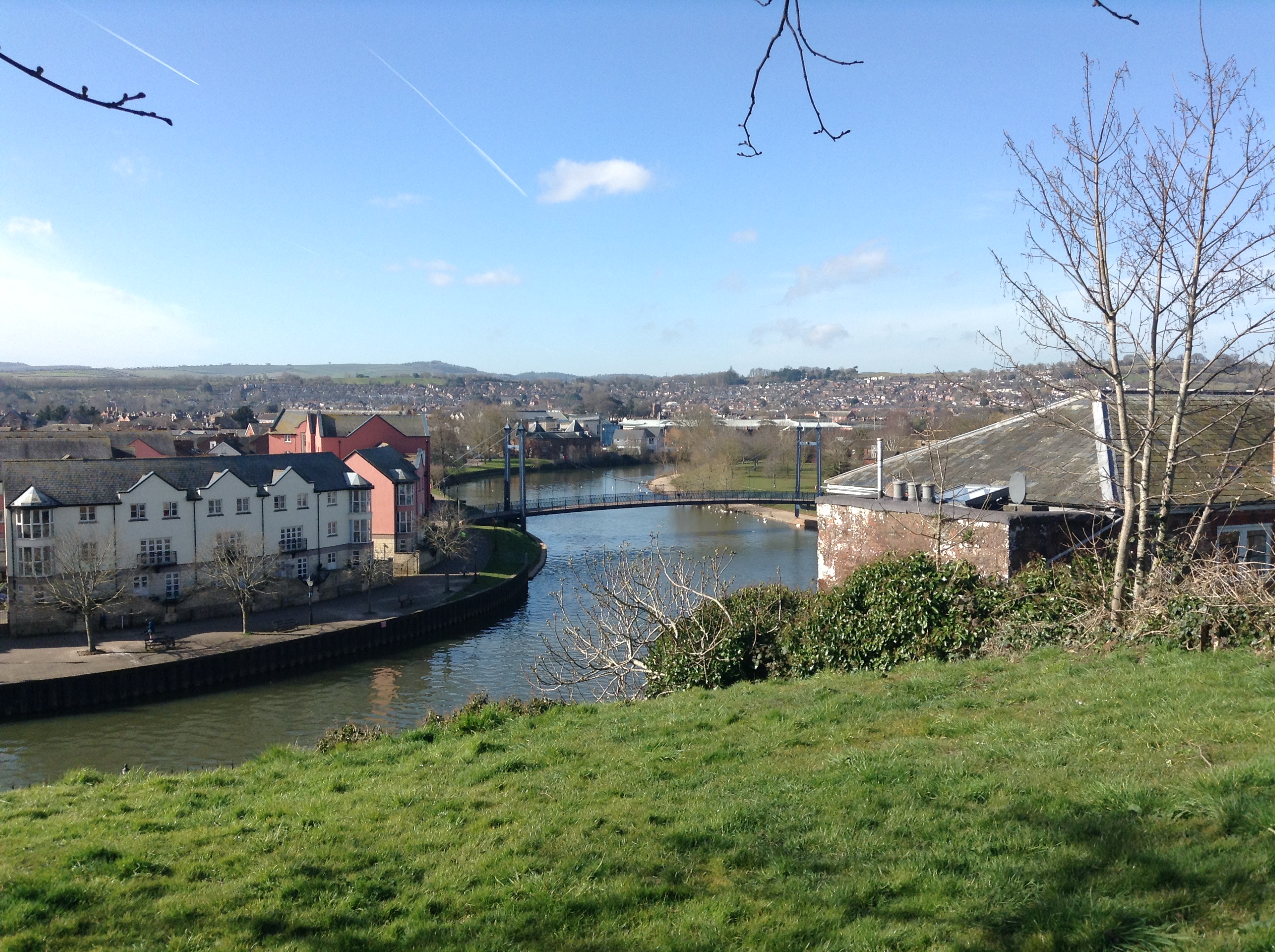
 The Exe Estuary from a balloon over Exeter. The M5 motorway is in the foreground, Topsham on the left bank just beyond, and Exmouth at the river mouth opposite Dawlish Warren. | |
| Location | |
| Country | England |
| Counties | Devon, Somerset |
| City | Exeter |
| Physical characteristics | |
| Source | Exe Head |
| • location | near Simonsbath, Somerset, England |
| • coordinates | 51°09′33″N 3°47′12″W |
| • elevation | 440 m (1,440 ft) |
| Mouth | Lyme Bay |
• location | English Channel |
• coordinates | 50°36′53″N 3°25′30″W |
• elevation | 0 m (0 ft) |
| Discharge | |
| • location | Thorverton |
| • average | 15.89 m3/s (561 cu ft/s) |
| • minimum | 0.44 m3/s (16 cu ft/s)27 August 1976 |
| • maximum | 492.6 m3/s (17,400 cu ft/s)4 December 1960 |
| Discharge | |
| • location | Stoodleigh |
| • average | 12.41 m3/s (438 cu ft/s) |
| Discharge | |
| • location | Pixton |
| • average | 4.47 m3/s (158 cu ft/s) |
| Basin features | |
| Tributaries | |
| • left | River Haddeo, River Culm, River Clyst |
| • right | River Barle, River Creedy |


Topography
The river's name derives from *Iska, a Common Brittonic root meaning "water" or "abounding in fish", and a cognate of pysg, the plural word for "fish" in Welsh.[2][3] The same root separately developed into the English Axe and Esk, the Welsh Usk, though not, as some have claimed, the word whisky, this latter being from the Classical Irish/Gaelic uisgi "water" (the fuller phrase being uisgi betha; Irish: uisce beatha; Scottish Gaelic: uisge beatha; "aqua vitae" ("water of life")).
The river's name occurs in Exeter ("fortress on the Exe") and many other settlements along its course, including Exford, Up Exe, Nether Exe, Exwick, Exton, Exminster, and Exebridge,[4] where it is joined by the River Barle. The seaside town of Exmouth is at the east side of the estuary mouth, and Dawlish Warren is at the west, with its long sand spit extending across the mouth.
The river fuelled Exeter's growth and relative importance in medieval times. The city's first industrial area was developed at Exe Island, which was created in the 10th century by digging a series of leats into the sandy and marshy land bordering the river. The island became home to numerous watermills producing paper and textiles.[5]
Tides on the river are limited at Trews Weir in Exeter, two kilometres upstream of Countess Wear, the site of a former weir commissioned by the Countess of Devon in the 13th century.[6] The Exeter Canal bypassed this weir to enable ships to reach Exeter Quay. At high tide, the estuary forms a large body of water that is heavily used for water sports especially sailing, windsurfing and water skiing.
Railways run along both sides of the estuary. The Avocet Line from Exeter to Exmouth on the eastern side, and the South Devon main line on the western. The latter is on a causeway, the South Devon Railway sea wall from Powderham to Dawlish Warren. The Exmouth to Starcross Ferry carries passengers across the mouth of the estuary during the summer months, linking the harbour at Exmouth with a pier adjacent to Starcross railway station on the South Devon main line.
At low tide, extensive mud flats are exposed, and these are an important feeding source for wading birds. Along with other rias in South West England, the Exe estuary is an important site for wintering waders. Dawlish Warren is a favoured site for birdwatching. The river has a low pH but does not suffer from a serious acid rain problem. It is populated with wild brown trout , and in the lower reaches coarse fish including dace, chub, perch, roach, pike and bream and some grayling, the average size being 8–10 ounces (230–280 g). There is a run of Atlantic salmon and a sparse run of sea trout. Just 150 metres (490 ft) below the union of the River Barle is Black Pool, which is one of the best, and highest salmon pools on the river. The smaller fish species present include stone loach and there are good reasons to assume others are present.
2008 cleansing operation
In 2008 the Environment Agency embarked on a project to clean the river from vegetation forming. In order to do so the water level decreased to its lowest level – lower than during the droughts the city has suffered.[7]
See also
- Rivers of the United Kingdom
References
- The Statesman’s Year-Book World Gazetteer ed. John Paxton
- Eilert Ekwall (1981). The Concise Oxford Dictionary of English Place-names. Oxford [Eng.]: OUP. p. 171. ISBN 0-19-869103-3.
- Owen, H.W. & Morgan, R. 2007 Dictionary of the Place-names of Wales Gomer Press, Ceredigion; Gwasg Gomer / Gomer Press; page 484.
- A.D. Mills (2003). A Dictionary of British Place-Names. Oxford Paperbook Reference. ISBN 978-0198527589.
- "The Leats of Exeter – a short history". Exeter Memories. Archived from the original on 15 August 2018. Retrieved 26 April 2019.
- "Exeter Memories - Countess Wear". www.exetermemories.co.uk. Archived from the original on 7 February 2008. Retrieved 12 March 2008.
- "River Exe runs dry to make way for Flood Defence Work". www.thisisexeter.co.uk. Retrieved 14 March 2008.
Further reading
- Lawrence, Rod (1999). The Exe: A River for Wildlife. Bradford-on-Avon.
External links
| Wikimedia Commons has media related to River Exe. |
Devon Portal | |
| Unitary authorities |
|
| Boroughs or districts |
|
| Major settlements |
|
| Rivers |
|
| Topics |
|
Somerset Portal | |
| Unitary authorities |
|
| Boroughs or districts |
|
| Major settlements |
|
| Rivers |
|
| Topics |
|
На других языках
[de] River Exe
Der River Exe ist ein Fluss im Südwesten Englands.- [en] River Exe
[es] Río Exe
El río Exe (pronunciado ɛks) es un corto río costero de la vertiente del canal de la Mancha del Reino Unido que discurre por el sureste de Inglaterra. Nace cerca del pueblo de Simonsbath, en Exmoor, Somerset, cerca de la costa del canal de Bristol, pero fluye más o menos directamente hacia el sur, de manera que la mayor parte de su curso queda en Devon. Alcanza el mar en una sustancial ría, el estuario de Exe, en la costa meridional de Devon. Históricamente, su puente más bajo estuvo en Exeter, aunque hay hoy un viaducto para la autopista M5 alrededor de 3 km al sur del centro de la ciudad.[it] Exe (fiume)
L'Exe (in latino Isca, in cornico Avon Esk, in gallese Afon Wysg) è un fiume della Gran Bretagna. Nasce nei pressi del villaggio di Simonsbath nel parco nazionale dell'Exmoor nel Somerset, a pochi chilometri dal canale di Bristol e dopo aver attraversato una parte di questa contea e buona parte del Devon sfocia con un profondo estuario nella Manica presso la città di Exeter. Il fiume, oltre ad Exeter, dà il nome anche ad altre città poste lungo il suo corso come Exford, Up Exe, Nether Exe, Exwick, Exton, Exminster e Exbridge.[ru] Экс (река)
Экс (англ. Exe) — река в Англии, протекающая по территории графств Сомерсет и Девон. Протяжённость реки составляет 88 км. Площадь водосборного бассейна — 1500 км². Средний расход воды — 15,89 м³/с.[источник не указан 637 дней]Другой контент может иметь иную лицензию. Перед использованием материалов сайта WikiSort.org внимательно изучите правила лицензирования конкретных элементов наполнения сайта.
WikiSort.org - проект по пересортировке и дополнению контента Википедии