geo.wikisort.org - River
The River Aller is a small river on Exmoor in Somerset, England.
| River Aller | |
|---|---|
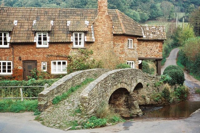 Packhorse Bridge, Allerford | |
| Location | |
| Country | England |
| State | Somerset |
| Region | Exmoor |
| District | West Somerset |
| City | Allerford |
| Physical characteristics | |
| Source | |
| • location | Holnicote, West Somerset, Exmoor, Somerset, England |
| • coordinates | 51°11′54″N 3°32′52″W |
| Mouth | Porlock Bay, Bristol Channel |
• location | near Hurlestone Point, Somerset, England |
• coordinates | 51°13′31″N 3°35′10″W |
• elevation | 0 m (0 ft) |
| Basin features | |
| Tributaries | |
| • left | River Horner |
It rises as several small streams around Tivington and Huntscott and flows through the Holnicote Estate passing Holnicote and through Allerford, where it passes under a packhorse bridge of medieval origin.[1] It then joins the River Horner, which flows into Porlock Bay near Hurlstone Point on the Bristol Channel.[2]
Because of the surrounding geology the area has been at risk of flooding. To help manage this risk telemetry monitoring of flows and a siren warning system have been proposed.[3]
References
- "Packhorse Bridge". historicengland.org.uk. Retrieved 5 January 2008.
- "River Aller". Somerset Rivers. Retrieved 23 September 2012.
- "West Somerset Catchment Flood Management Plan" (PDF). Environment Agency. p. 12. Archived from the original (PDF) on 17 December 2012. Retrieved 23 September 2012.
Somerset Portal | |
| Unitary authorities |
|
| Boroughs or districts |
|
| Major settlements |
|
| Rivers |
|
| Topics |
|
Текст в блоке "Читать" взят с сайта "Википедия" и доступен по лицензии Creative Commons Attribution-ShareAlike; в отдельных случаях могут действовать дополнительные условия.
Другой контент может иметь иную лицензию. Перед использованием материалов сайта WikiSort.org внимательно изучите правила лицензирования конкретных элементов наполнения сайта.
Другой контент может иметь иную лицензию. Перед использованием материалов сайта WikiSort.org внимательно изучите правила лицензирования конкретных элементов наполнения сайта.
2019-2026
WikiSort.org - проект по пересортировке и дополнению контента Википедии
WikiSort.org - проект по пересортировке и дополнению контента Википедии