geo.wikisort.org - River
The Lyd is a river rising at Lyd Head[1] (Corn Ridge in NW Dartmoor) in the Dartmoor national park in Devon in South West England and flowing into the River Tamar beyond Lifton.[2] It runs through Lydford Gorge, the deepest gorge in South West England.
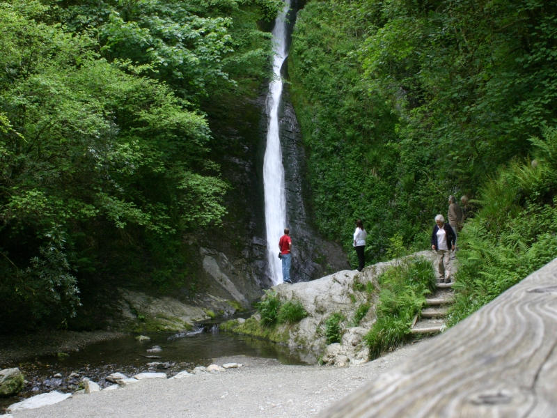

Lydford Gorge
Lydford Gorge (National Trust) is a dramatic feature of the river at Lydford on the edge of the Dartmoor National Park; it is a 1.5-mile (2.4 km) gorge near Lydford on the River Lyd, which is the deepest in South West England. It was formed by the process of river capture, where the start of a nearby river eroded backwards until its origin met the Lyd, diverting its course into the second channel.[3]
Owned and maintained by the National Trust since 1947, the gorge features the 100-foot (30 m) tall White Lady Waterfall and a series of whirlpools known as the Devil's Cauldron.[4]
External links
References
- Dartmoor (Explorer Map OL28) (B3 ed.), Ordnance Survey, 2010, ISBN 978-0-319-24143-1
- Launceston & Holsworthy (Explorer Map 112) (B1 ed.), Ordnance Survey, 2005, ISBN 978-0-319-23711-3
- "Lydford Gorge" (pdf). Educational Register of Geological Sites. Devon County Council. Retrieved 24 December 2010.
- "Get your toes wet at Lydford Gorge". BBC. 2003. Retrieved 24 December 2010.
This Devon location article is a stub. You can help Wikipedia by expanding it. |
Другой контент может иметь иную лицензию. Перед использованием материалов сайта WikiSort.org внимательно изучите правила лицензирования конкретных элементов наполнения сайта.
WikiSort.org - проект по пересортировке и дополнению контента Википедии